Posts

Showing posts from August, 2022
Image
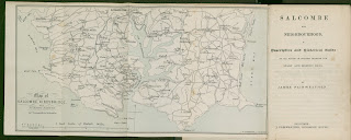
  James Fairweather   One of only two popular guide books on Salcombe to be written in the nineteenth century was Salcombe and Neighbourhood, a Descriptive and Historical Guide. This was written by the local printer and publisher, James Fairweather , who also commissioned a map by Maddock to accompany the first edition of the guide. The Preface makes it clear that much of the text had already appeared in the Salcombe Times , this was a newspaper published each Friday at the cost of one penny per issue and which included local and general news and a serial tale . Some of the text from this work was reworked and issued as a shorter guide, Salcombe as a Health and Pleasure Resort   (but with no map) about 1890 [1] . The original work was revised and republished as Salcombe, Kingsbridge and Neighbourhood   in a second edition in c .1896 with a new map (see Fairweather - Stanford - below). Besides one further work on the great blizzard   of 1891, Fairweather does not seem to have publis
Image
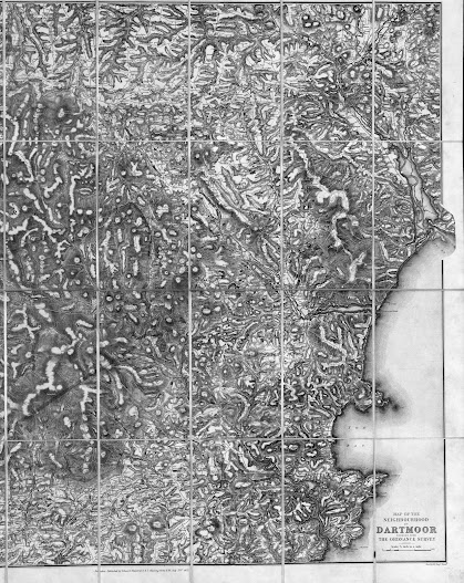
  EDWARD STANFORD   Edward Stanford founded the business of Stanford's Geographical Establishment  and the company became one of the most productive during the second half of the 1850s. A large number of county maps of Devon were produced by the company (see B&B 154 , 155 and 161 ) as well as a very large number of sectional and regional maps of the county (e.g. for Cressswell and Gegory). The map below was produced at the time of the military manoeuvres which took place on Dartmoor  during the year 1873. The map, Autumn Manoeuvres, 1873. Map of the Neighbourhood of Dartmoor, reduced from the Ordnance Survey (cover title), is a direct copy of the OS one inch to a mile map produced by Lieutenant-Colonel William Mudge  etc ( B&B74 ) in 1809 but reduced to exactly ¾ the scale. [1] Although not a typical tourist map, the adverts on the inside cover and the amount of detail devoted to hill-shading make it clear that it was one of Stanford’s many commercial ventures. In ad
Image
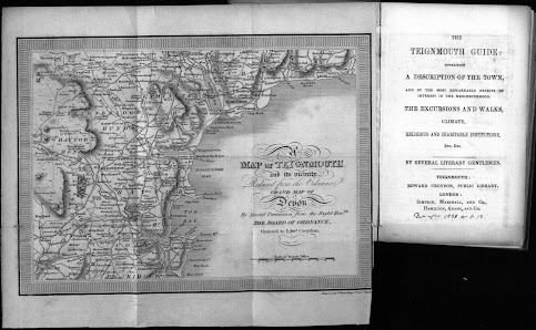
 Edward  Croydon 2   W Read, who engraved this small map for the Teignmouth Guide, was a line and stipple engraver of portraits, landscapes as well as topographical views after his contemporaries [1] . He also produced 4 or more aquatints after T E Chapman for Aquatint Views of Dawlish published by Jane Gore and J Knighton in Dawlish, c. 1828. In addition he executed at least 4 aquatints after L E Reed which was also published by Croydon c. 1825. See S.76. Size: 175 x 240 mm. Scale of Statute Miles (10 = 58 mm). A MAP OF TEIGNMOUTH and its vicinity Reduced from the Ordnance GRAND MAP OF DEVON By Special Permission from the Right Honble THE BOARD OF ORDNANCE, Granted to Edwd Croydon. (Ee). Engraver’s signature: Engraved by W Read King St, Covt Garden. (CeOS). Piano-key style frame. Coast is shown from Beer Head to the Mew Stone south of Berry Head and inland to Gidley and Modbury. 1. 1826 The Teignmouth Guide Teignmouth. E Croydon. (1826), (1827). DevA, [NDL]; De
Image
 Edward Croydon 3 Handbook for Torquay   The Handbook For Torquay and its Neighbourhood   was originally published in 1854 with dated title page. There may have been two variations – with or without map – as many libraries do not mention a map. The book was probably published by Croydon for the visitors to Torquay, but he used Hamilton & Adams   for London distribution as he had done for other works and the London printers Bradbury and Evans of Whitefriars. The work was slightly revised 15 years later and reissued. All copies of this “second edition”so far seen have no date on the title page but they do have an advert for Stewart ‘s Handbook of the Torquay Flora   on the back endpaper: this was published by Croydon in 1860 with Hamilton, Adams and Co., as co-publisher. [1] The original text was probably written between 1852 and 1853: the first edition mentions a visit by Queen Victoria to Tor Bay in July of the last year , but this is amended in the later text to in July 1852 ; in
Image
E Culverwell / Richard Lethaby (Peter Orlando Hutchison)   This simple sketch map of the town of Sidmouth is known in two states, but in works separated by nearly twenty-five years. It was originally printed in The Sidmouth Directory , September 28th, 1869, published by Richard Lethaby (on the first of every month) [1] . The second version of 1894 was included in issues of the eighth edition of P O Hutchinson‘s guide to Sidmouth [2] . The map was incorrectly ascribed to Culverwell in the First Edition of Tourist Maps . Originally appearing in 1857 as A New Guide to Sidmouth and the Neighbourhood , Hutchinson’s guide was reissued from 1862 as A Guide to the Town and Neighbourhood of Sidmouth . For the 8th edition a new title was chosen and this, much earlier, map included. This sketch map appears in all paperback copies of this edition inspected. One hardback edition at Devon Archives also includes a much later, and lithographically reproduced, version of a map by Wallis [3] . The small
Image
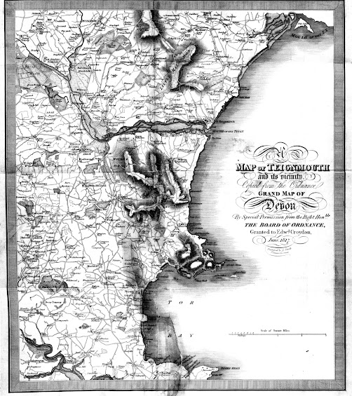
 Edward Croydon, Senior and Junior For more information on Croydon, see my article on Torquay booksellers. Click here. Edward Croydon and his two sons, Henry George (Teignmouth) and Edward (Torquay) published three maps. Croydon 1 - see below. Croydon 2 - The Teignmouth Guide (later also  The Torquay Guide ) - click here. Croydon 3 - Torquay and its Neighbourhood - click here.  In 1817 E dward Croydon  printed and sold a most attractive guide books of Devon. The Guide to the Watering Places, on the Coast, Between the Exe and the Dart ; … consisted of sixteen (and occasionally found with 17) coloured aquatints (of which four are folding) by D Havell , T Shury , and J C Stadler , after drawings by W B Noble  (JVSC S.64). This was originally issued in three parts published in 1817 and 1818 with a map engraved by J Smith  of London when bound complete [1] . Although all title pages to the first printing are dated 1817, at least seven of the views included are dated June 15 1818 suggest