Showing posts with label Ordnance Survey. Show all posts

Sunday, 4 September 2022

 The Ordnance Survey – Tourist Maps (combining multiple sheets) 


OS 5 – Torquay 2 

Size: 730 x 510 mm. Scale of One Inch to One Statute Mile (8F + 4 = 130 mm) Miles. 

TORQUAY (CaOS). Above the map are: ORDNANCE SURVEY OF ENGLAND (AaOS) and PARTS OF SHEETS 324, 325, 338, 339, 349, 350 (EaOS). Signature: Revised in 1896 and Published at the Ordnance Survey Office, Southampton, 1901 (EeOS).

Parts of OS sheets 324, 325, 338, 339, 349 and 350 printed as one sheet to form a map of the area surrounding to the north of and surrounding Tor Bay. Scale of 1 inch to mile. Compass with magnetic deviation in margin (EdOS). Area is from Exeter in the north with the coast from Exmouth as far as Stoke Fleming and inland (west) as far as Chagford, Widecombe and South Brent. Scale 1 Inch to a Mile (printed red waterproof covers with OS crest and reference to sheet numbers). 

1. 1901 Ordnance Survey. Torquay. 
Southampton: Ordnance Survey Office. 1901. TQ, [BL].

  The Ordnance Survey – Tourist Maps (combining multiple sheets) 

OS 4 – North Devon  

Size: 460 x 775 mm.  Scale of One Inch to One Statute Mile (8F + 4 = 125 mm) Miles.
 

NORTH DEVON (CaOS). Above map are: ORDNANCE SURVEY OF ENGLAND (AaOS) and SHEETS 276, 277, 293  / PARTS OF SHEETS 278, 292, 294 (EaOS). Signature: Revised in 1896-7 and Published by Colonel D A Johnston, R E Director General. 1901 (EeOS) with second line: Printed at the Ordnance Survey Office, Southampton in 1901 (also EeOS). Price 1s. 3d.

OS sheets 276, 277 and 293 (complete) with parts of 278, 292 and 294 printed as one sheet to form a map of North Devon. Scale of 1 inch to mile. Compass with magnetic deviation in margin (EdOS) (printed red waterproof covers with OS crest and reference to sheet numbers). 

1. 1901  Ordnance Survey. North Devon.

              Southampton: Ordnance Survey Office. 1901, 1903. BL[1].


NOTES:


[1] Illustrated is the author's copy with note: Reprint 500/1903, price now 2s.


 The Ordnance Survey – Tourist Maps (combining multiple sheets) 


OS 3 – Dartmoor    

Size: 635 x 485 mm. Scale of One Inch to One Statute Mile (8F + 4 = 125 mm) Miles. 

DARTMOOR (CaOS) with signature: Revised in 1896 and Published by Colonel D A Johnston, R E Director General. 1900 (EeOS). Second line: Printed at the Ordnance Survey Office, Southampton in 1900 (also EeOS). Above map are: ORDNANCE SURVEY OF ENGLAND (AaOS) and SHEETS 324 / 328 (EaOS).

OS sheets 324 and 338 (complete) printed as one sheet to form a map of Dartmoor. Scale of 1 inch to mile. Compass with magnetic deviation in margin (EdOS).Small illustration below map of adjoining sheets.

Area covered from Hatherleigh and Zeal Monochorum in the north to Harrowbeer and Ashburton in the south in (plain red waterproof covers with paper label). 

1. 1900            Ordnance Survey. Dartmoor. 1 Inch to a Mile 

                        Southampton: Ordnance Survey Office. 1900.  KB.


 The Ordnance Survey – Tourist Maps (combining multiple sheets) 

OS 2 – Plymouth 

Size: 505 x 640 mm.  Scale of One Inch to One Statute Mile (8F + 4 = 125 mm) Miles. 

PLYMOUTH (CaOS). Above the map are: ORDNANCE SURVEY OF ENGLAND (AaOS) and SHEETS 337.  338. / 348. 349. / 354. 355. (EaOS) with signature: Revised in 1894 and Published by Colonel D A Johnston, R E Director General. 1899 (EeOS). There is a second line: Printed at the Ordnance Survey Office, Southampton in 1899 (also EeOS). Reprint 300 / 1900 (AeOS).

Parts of OS sheets 337, 338, 348, 349, 354, 355 printed as one sheet to form a map of the area surrounding Plymouth. Scale of 1 inch to mile. Compass with magnetic deviation in margin (EdOS). Area is from East and West Looe to Kingston and mouth of Erme and inland to Tavistock. Scale 1 Inch to a Mile (printed red waterproof covers with OS crest and reference to sheet numbers)

1. 1899 Ordnance Survey. Plymouth. 
Southampton: Ordnance Survey Office.. 1899 (1900). KB, [BL].


The Ordnance Survey – Tourist Maps (combining multiple sheets) 

The Ordnance Survey were still selling their original first generation sheets of Devon as produced by William Mudge in 1809 (see B&B 74) towards the end of the 1800s. They were now cheap to produce being Printed from an Electrotype and sold by a number of mapsellers such as Letts, Son and Steer and in various combinations of sheets, often in slipcases. But steadily, throughout the 1890s, the OS was busy resurveying the county. The individual sheets were obviously being printed but to what extent they were put on sale is still uncertain. However, as well as producing the individual sheets from the revised one inch survey and derivatives, such as combined double and quarter page maps, a few areas were covered especially by the Ordnance Survey and awarded special folding map status in their own covers.

At the same time the OS were selling sheets at 1:500 and Edwin Chapple, Government Agent for Ordnance Survey Maps in Plymouth, was advertising various towns in Devon and Cornwall at this scale, e.g. Plymouth, Devonport and Stonehouse on 79 sheets. The 1:2500 series was also on offer as well as the 6” to a Mile as so-called quarter sheets. These maps were not designed primarily for tourists and have not been covered in this work.

However, Chapple was advertising the 1” to 1 mile scale maps as very useful to tourists, pedestrians, and cyclists just before the turn of the century. As can be seen from the maps listed here the Ordnance Survey were busy revising their maps in the late 1890s; Plymouth was revised 1894, Dartmoor in 1896 and Torquay and North Devon in 1896-7. These areas were treated specially with the production of maps which included multiple sheets (e.g. Dartmoor) or combinations of sheets and part sheets (e.g. Plymouth and North Devon) of the full survey. Chapple was also advertising maps of Bideford, Holsworthy, Tavistock, Exeter[1] and Ivybridge at this scale but these have not yet been identified, but presumably were also available in this format designed for early tourists. More maps are likely to be found.

Chapple was obviously keen to secure all OS business and his flyer (found, for example, in the Plymouth and Dartmoor maps) has: The Government has established these Agents in all the larger towns throughout the Kingdom, with the desire to make the Maps more easily and readily accessible to the public, and it is hoped that every support will be accorded to the Local Agent, who is in a better position than any other person to supply the Maps of the District. The other agents for Devon seem to have been H S Eland at 236 High Street, Exeter and Mr Andrew Iredale in Torquay.

Brevet Colonel D A Johnston was appointed Director General of the Ordnance Survey in 1899 but served only a few years. He was appointed a Knight Commander of the Order of Saint Michael and Saint George in King George’s birthday honours list on the occasion of his sixty-fifth birthday (1906).

Five maps are included here (others may be found later):

OS 1 - Torquay 1 (1899) - see below

OS 2 - Plymouth 1899 (1900)

OS 3 - Dartmoor (1900)

OS 4 - North Devon (1901)

OS 5 - Torquay 2 (1901)


OS 1 –Torquay 1 

Size: 530 x 480 mm. Scale of One Inch to One Statute Mile (8F + 4 = 130 mm) Miles. 

TORQUAY (CaOS). Above the map are: ORDNANCE SURVEY OF ENGLAND (AaOS) and SHEETS 350. / 356. (EaOS) with signature: Revised in 1896-97 and Published at the Ordnance Survey Office, Southampton, 1899 (EeOS).

OS sheets 350 and 356 printed as one sheet to form a map of the area surrounding Tor Bay. Scale of 1 inch to mile. Compass with magnetic deviation in margin (EdOS). Area is from St Marychurch in the north to Start Point and inland as far as Harbertonford and Dartington just west of Totnes (printed red waterproof covers with OS crest and reference to sheet numbers).

1. 1899      Ordnance Survey. Torquay
                    Southampton: Ordnance Survey Office. 1899. TQ.


NOTES:

[1] The British Library has a map of Exeter (535 x 738 mm) which they date 1899. As the scale is 1" to a mile it may be one of these. Certainly sheet 93 showing an area from Hatherleigh (NW) to Tor Bay at two miles to an inch was on sale, possibly from 1896 when it was reduced from the 1" map, in a red cover as a folding map.

Monday, 25 October 2021

 John Cary - Arthur Westley

Arthur Westley began business in the late 1870s taking over from Edward Cockrem (see Cockrem 5). He seems to have commissioned only one map (but it may also have been taken over from Cockrem) but was offering a range of different maps of Torquay and the neighbourhood between 1880 and 1885. One of the maps he offered was taken from  the Cary plates of the Improved Map. His business was, in turn, taken over by Leonard Seeley.

 L Seeley was a Torquay bookseller and library proprietor. In circa 1885 he was issuing a map based on work by Cary’s Improved map only differing from Westley’s in small details and a slight “shift to the east”. Also at about this time he was selling an updated version of a map produced by W Elliott which was now some 50 years old (c.f.). Exactly which map replaced which, or whether Seeley was selling both together cannot be clarified. However, the selection of other items being sold (on back cover) seems to indicate that the company was concerned with selling a range of services more in line with the general bookseller and printer (eg note paper, visiting card plates) than the specialist agent for travellers’ wants. On the other hand the Cary map was much more detailed than the Elliott map and would have been better for a potential traveller.

Other publishers and booksellers were also using ex-Cary map products (taken over in the meantime by Gall & Inglis) such as A H Swiss of Devonport for his hunting maps. This Westley/Seeley version must, however, pre‑date Swiss if the railway information is up to date; both retain information such as rocks and coastal depths found on the Cary maps, but later erased before being used by Swiss.

 Cary Improved 3 (Westley)  

Size: 490 x 600 mm.                                      Scale of English Miles (10 = 130 mm). 

WESTLEY'S MAP OF TWENTY FIVE MILES ROUND TORQUAY, Reduced From The  ORDNANCE SURVEY. (De). Below this a note: Circles Represent Two Miles. Imprint: PUBLISHED BY ARTHUR WESTLEY Librarian, Bookseller, and Stationer 10 STRAND, TORQUAY (Ee). Scale Ae).

The map covers south Devon from Rame Head and Saltash with Lifton Station just inside the border to Chit Rock and Sidmouth (not named) with everything below Exeter and Okehampton, thereby missing the eastern edge, i.e. anything east of Venn Ottery aas well as Honiton. There are radiating circles outwards from Torquay. It has railways consistent with a date of c. 1880; no Yelverton to Prince Town line (1883) and the line to Ashton is not yet projected.  

1.1884       Westley’s map of Twenty Five Miles Round Torquay        Torquay. Arthur Westley. (1884).          BL[1].

 2.1885     SEELEY'S MAP OF THE ENVIRONS OF TORQUAY, FROM THE ORDNANCE SURVEY. (Ee). Imprint: SEELEY'S LIBRARY, TORQUAY (AeOS). Scale (EeOS). Size: 490 x 615 mm. Illustrated.          The map covers almost the same area of south Devon from Plymouth to Salcombe Regis and everything below Exeter, thereby missing the eastern edge and anything west of Beer Alston as well as Honiton but shows only a small part of Rame Head (in full on Wesley) and extends further eastalmost  to Beer Head. It has railways consistent with a date of c. 1880; the Yelverton to Prince Town line (1883) is not yet included and the line to Ashton is dotted as projected (opened October 1882). 

 Seeleys' Reduced Ordnance Map Of The Environs Of Okehampton, Exeter, Dartmoor, Plymouth, Dartmouth and Torquay ... L Seeley & Son. (Cover title)       Torquay. L Seeley. (1885).         TM[2]. 


Cover


For Cary´s county maps refer to The Printed Maps of Devon entries 515455697173 and 92. Click reference number to open directly.

For Cary´s New Map of England and Wales so-called "square atlas" - click here.

For Cary´s Improved Map of England and Wales as issued by Cary and others - click here.

For the section of Improved Map of England and Wales as issued by John Heydon - click here.

For the section of Improved Map of England and Wales as issued by A H Swiss click here.

For the section of Improved Map of England and Wales as issued by Thomas Doidge click here.

For the sections of Improved Map of England and Wales as printed by Gall & Inglis for two Exeter companies (Henry Eland and Standfield & White) click here.

For the 2 sections of Improved Map of England and Wales as used by Beatrix Cresswell - click here.

For the section of Cary´s Reduced Ordnance Map of England and Wales as issued by G F Cruchley to show Dartmoor Maneouvres - click here.

To return / access the Catalogue of Maps in this work - click here


[1] BL Maps 2123 (12.) with accession date October 1884. Mounted on linen with (front) cover pasted on reverse: Westley’s Reduced Ordnance Map of Twenty-Five Miles Round Torquay. Distances are shown by Two-Mile Circles. Price 1/6.

[2] Illustrations courtesy of Torquay Museum; all rights reserved. 


Saturday, 7 August 2021

 George Washington Bacon 3

Bacon 3

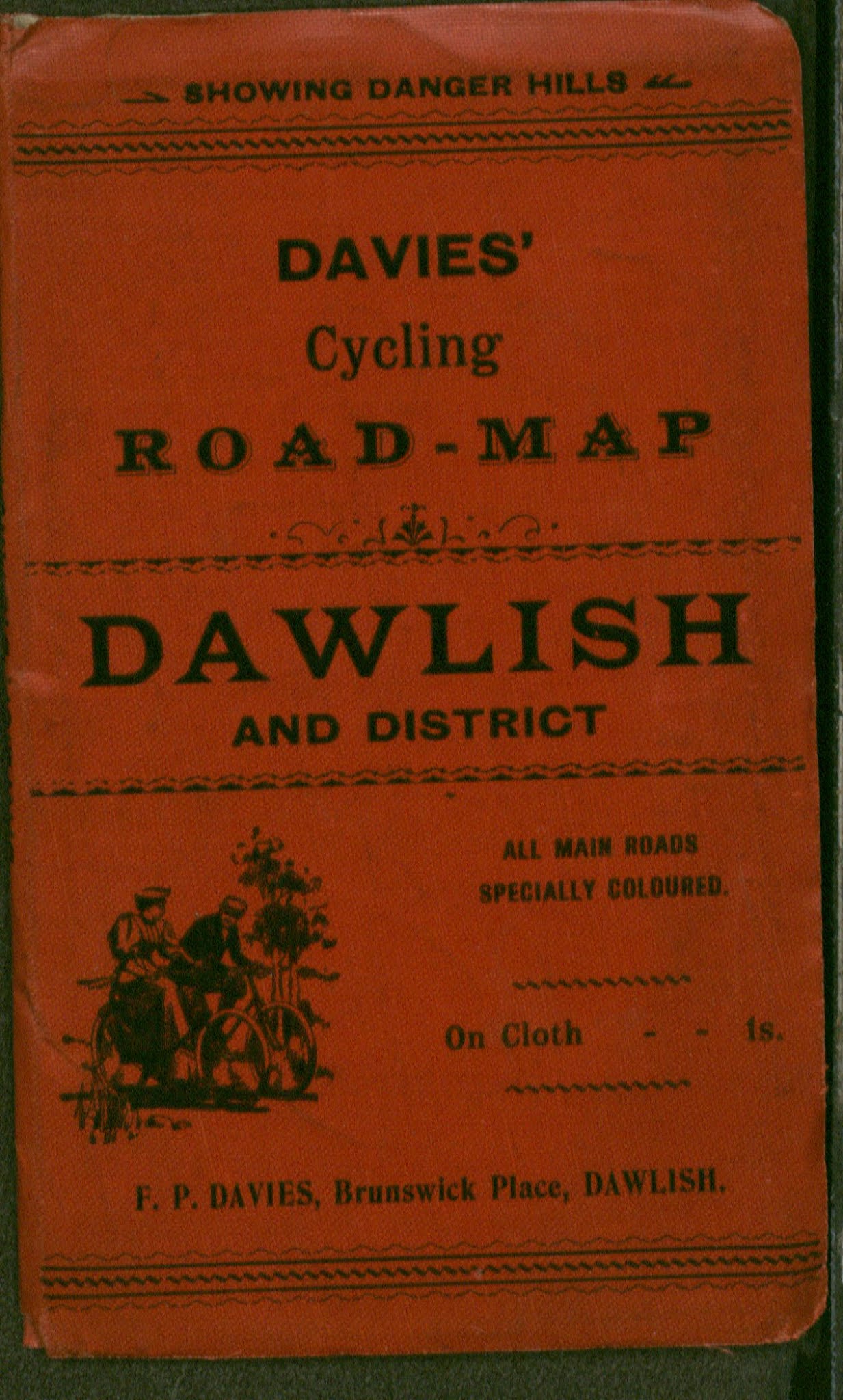
The following maps were taken from an unidentified set of plates. The scale is unusual at 3 miles to an inch and the maps so far seen have circles radiating out from Exeter, previously only seen in the revised Cary maps by George Richmond and A H Swiss (Batten and Bennett 138A). Both maps were printed by Bacon and then put in covers for local firms. The covers are a typical size for Bacon (170 x 100 mm) but are bright red only with black writing and (different) illustrations of cyclists. The first map below has an extra line: Revised according to the latest Ordnance Survey but this was probably only an advertising gimmick. 


Size: 460 x 580 mm.          Scale: 3 miles to an inch (5 + 10 = 125 mm).

No Title. Imprints: G W Bacon & Co., Ltd., 127 Strand, London (AeOS). Notes: Selection of Routes, Scale bar, Reference and note Divided into 5 mile Squares and Circles with Hills to be ridden with caution (all Ee).

Three-line border broken for Launceston, Bridgewater, Somerton, Beaminster and Bridport. Area covered is that north of Plymouth and Dartmouth and south of Barnstaple (all of which are included) and east to towns above. Railways to Yealmpton and Lynton (as light railway), constructing to Northam (dotted) but not the post-1900 lines Budleigh Salterton to Exmouth or Ashton to Exeter. Folding into red cloth covers with name and address of R & M Tucker, Stationers, Honiton.

 1. 1899  

Tucker’s Cycling Road-Map Honiton and District (cover title)  
Honiton. R & M Tucker. (1899).     KB.


 2. 1900  Folding into red cloth covers with name and address of F P Davies, stationer at Brunswick Place, Dawlish. Printer’s mark 33M15 (EeOS). Railway to Northam completed but not Budleigh Salterton to Exmouth or Ashton to Exeter. Illustrated.

Davies’ Cycling Road-Map Dawlish and District (cover title)  
Dawlish. F P Davies. (1900).            KB.


RETURN to List of Bacon Maps

 Edward Croydon 4 Shortly after the arrival of the South Devon Railway into Teignmouth, Edwad Croydon published a detailled plan of the town...