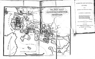
Robert Brindley Not much is known of Robert Brindley b esides him being the artist and engraver of the map below for The Plymouth, Stonehouse and Devonport Directory in 1830 which was also published by Byers . William Byers was printer, bookseller and bookbinder with various addresses in Fore Street from 1823 to 1852 [1] although he originally registered his press in 1818 (19/2/1818, DRO Q/S 52). He was the proprietor and publisher of Devonport Independent and Plymouth and Stonehouse Gazette from about 1840 to 1852 and published later editions of A Walk Round Mount Edgcumbe .a popular guide (see Byers / Cooke). He was also one of the leading producers of lithographs of local scenes. He published the second and subsequent editions of Henry E Carrington ‘s The Plymouth and Devonport Guide with issues from 1830 to 1850 ( c.f. below and Becker 1). He advertised himself as Bookseller &c to Duke of Clarence 1828-1830 and subsequently as Bookseller etc...
Posts
Showing posts with the label Byers
- Get link
- X
- Other Apps

Francis Paul Becker Francis Paul Becker was famous for his Omnigraph (a versatile ruling machine) invented in the early 1840s. This was was designed to apply commonly occuring symbols onto maps automatically, saving the engraver time and effort. Becker sold it to the Ordnance Survey, claiming that it would save £5000 a year on the staff of forty five engravers. It was used until 1875 when the survey decided that it was actually more costly than hand production because of the great amount of manual retouching required by 'Omnigraph'-produced signs’. [1] Nevertheless, the company of F P Becker & Co ., Omnigraph (litho) Engravers , seems to have been very successful and produced maps for a variety of different publishers besides the two entries below: eg Fisher's County Atlas of England and Wales (thought to be the first to use the omnigraph) , Adlard's Ireland , Frederic Kelly's Post Office Directories , the map of England and Wales in Barclay's Dic...