Showing posts with label Sidmouth. Show all posts

Sunday, 8 October 2023

 JOHN WALLIS

John Wallis was the son of a well-known London map publisher of the same name. John Senior was joined by his son, Edward (who was thus possibly older than John Junior), and the younger John moved to Sidmouth where he worked as a book and print seller at the Royal Marine Library.

The first map associated with John Wallis was a small map executed by Neele (c.f.) included in the work A Descriptive Sketch of the Beauties of Sidmouth. Although not dated, it appeared ca. 1810, just a year after Wallis had established his library on the beach. A very attractive work by H Haseler and H Cornish, Scenery on the Southern Coast of Devonshire: Comprising Picturesque Views at or near the Fashionable Watering Places, Sidmouth, Budleigh Salterton, Exmouth, Dawlish, Teignmouth, and Torquay, was published by John Wallis about 1819 and included 30 plates. George Rowe‘s Forty-Eight Views of Cottages and Scenery at Sidmouth, Devon, appeared circa 1826 with 48 lithographs.

The map below does not seem to have been published in book form originally and was possibly a so-called broadsheet, i.e. sold separately. It was, however, reissued by J Harvey when it was included to illustrate two books by local people. The first was a guide book of the area by the Rev. T H Mogridge whose A Descriptive Sketch Of Sidmouth appeared only in 1836. A year later the map appeared with minor changes in an autobiography by the well-known local smuggler, John Rattenbury, in his memoirs.


John Rattenbury, Smuggler

This map has also been seen as a folding map in covers but together with a smaller sketch map of the town of Sidmouth which must be at least 30 years later (c.f. Culverwell). After nearly 70 years the map was republished by C Culverwell in later post-1900 editions of An Illustrated Guide to the Town and Neighbourhood of Sidmouth. This was a guide book written by Peter Orlando Hutchinson in the 1850s.


Size: 255 x 435 mm. (1/2 + 10 = 135 mm) SCALE OF MILES.

MAP OF THE COUNTRY ROUND SIDMOUTH to the extent of 20 miles. In frame with imprint: Published August 12th 1822, by JOHN WALLIS, at the ROYAL MARINE LIBRARY, SIDMOUTH. (Aa).

The area covered is from The Ness at Teignmouth (Ae) along the south coast as far as Lyme Regis (Ee) and including Crediton (Aa) and Pitminster (Ea). The map is oriented with the coast horizontal, ie to the northeast. The map is a close copy of part of sheet 10 from the Cary 65-sheet set.

1. 1822 Loose sheet as described, probably sold separately. KB.

2. 1836 Imprint changed: SIDMOUTH: Published and Sold by J HARVEY. 1836. (Aa).

A Descriptive Sketch Of Sidmouth by Rev. T H Mogridge
Sidmouth. J Harvey. (1836), (1838). KB, [NDL], [Sid]; BL[1].

Map Of Sidmouth (folding into covers with map Culverwell 1 on inside cover)
Sidmouth. J Harvey. (1836). DevA.


3. 1837 The map is now titled: MAP OF THE COUNTRY ROUND BEER to the extent of 20 miles. The date is changed to 1837. (Aa). BEER replaces Beer.

Memoirs of a Smuggler Compiled from his Diary and Journal
Sidmouth. J Harvey. 1837. BL, KB, [DevA], [Sid].


4. 1894 Original title with new imprint: Published & Sold by C Culverwell Sidmouth. Map is lithographically reproduced. Railways added (including Sidmouth and Hemyock, 1874 and 1876). The lines are printed red, as are the names of the stations.[2]

An Illustrated Guide to the Town and Neighbourhood of Sidmouth; ... Eighth Edition
Sidmouth. E Culverwell. (1894). BL, DevA.

The map also appeared post-1901:

5. 1903 Title and imprint as above. Railways added (including Exmouth to Budleigh Salterton, 1903). The lines are printed red, as are the names of the stations.[3]

An Illustrated Guide to the Town and Neighbourhood of Sidmouth; ... Ninth Edition
Sidmouth. E Culverwell. (1903 or later). KB.


RETURN to Catalogue of Maps 
NOTES:

[1] The BL copy is BL 01360.p.11, it is not known why they date the copy to 1838 as on page 14 there is a clear reference to the text being written in 1836; their copy of Rattenbury’s memoirs is BL 10827.a.14.
[2] Hardback editions of the Eighth Edition only.
[3] Hardback editions of the Eighth Edition may have included this map.


Saturday, 3 September 2022

Samuel and James Neele 

Neele 1

Samuel and James Neele were active from the 1790s to early 1800s. One or other of the Neeles engraved two of the plans included in Charles Vancouver's work, A General View of the Agriculture of the County of Devon and other county volumes in the same series have county maps signed Neele (see B&B 70). Other county maps of Devon executed by the Neeles are known from 1803 (Wilkes, see B&B 64), and 1819 (B&B 86).

The Beauties of Sidmouth Displayed is attributed to Edmund Butcher  (1757-1822), a Unitarian minister. Poor health forced him to retire to Sidmouth, where he lived for many years producing sermons and the local guide. In 1805 he wrote An Excursion from Sidmouth to Chester published by Symonds and Woolmer and this may have encouraged him. Consequently, although the first edition of Sidmouth Displayed, ... being a descriptive sketch of its situation, salubrity, and picturesque scenery, also an account of the environs within fifteen miles round, has no author on the title page and the dedication (to the resident nobility and gentry and to visitors) is signed by the publisher John Wallis, from the Sidmouth Marine Library, the text is attributed to Butcher. The first edition contained a map by Neele and one other illustration (View of the Beach and Peak Hill). Later editions (1820 or later) were richly illustrated (see Somers Cocks entry S.62). A fourth edition appeared in 1830 with the new title A New Guide, Descriptive of the Beauties of Sidmouth. Another book of Views of the Principal Cottages and Residences etc., appeared as Sidmouth Scenery in 1817, also published by Wallis (views in author´s copy are illustrated here) and included the map in revised form. There were two issues of this work with either 20 or 22 views. The first issue, with text, is believed to be a limited printing for subscribers: the second issue, lacking letterpress, has an extra two views dated 1819 and 1820.

Neele and Son were also responsible for producing a map and a plan for Narratives of two Excursions to the Ports of England, Scotland and Ireland. This work appeared about 1820 and was a translation and critique of Charles Dupin‘s visits to the British Isles made in the three previous years to study engineering projects. This work included a plan of Plymouth Sound by Neele as well as a diagram of the breakwater, recently completed (although extra work was carried out for the next twenty years!).[1] Click here to view Neele 2.


Neele 1

Size: 110 x 125 mm.  Scale of Miles (6 = 37 mm). 

THE ENVIRONS OF SIDMOUTH. (CaOS) Signature: Neele, sculpt, Strand (EeOS). A plain two line border. There is a simple compass (Bb) and map is oriented with north rotated approx. 100 degrees to right.

Description: The coast is shown from Tor Bay (Aa) to Lyme Regis (Ae); the inland area stretches to Bow and to Taunton Dean.   

1. 1810        The Beauties of Sidmouth Displayed
                    Sidmouth. J Wallis[2]. 1810. KB.

2. 1817 An extra border has been drawn around the map to include the title (i.e. now within border) and the new imprint. Map printed within a page with text below, not separately. Size now 135 x 120 mm on page 160 x 240 mm. Imprint: Pub'd May 1st 1817 by John Wallis, Marine Library, Sidmouth (Ce).
Additional placenames include Budleigh Salterton, Dunscomb and Shaldon but most noticeable is the adition of three hills, especially Hall Down together with the Obelisk at Chudleigh.


a) Page size is approx. 160 x 240 mm. Map not folded. 

Sidmouth Scenery; or, Views of the Principal Cottages & Residences of the Nobility and Gentry: with a Description of that Admired Watering-Place, and the Environs within Fifteen Miles Around … The Rev. E. Butcher. 
Sidmouth. J Wallis. (1817). P[3].

b) Page size is approx. 140 x 210 mm. Map folded twice. 

The Beauties of Sidmouth Displayed ... Third Edition ... by Revd Edmund Butcher
Sidmouth. J Wallis[4]. 1820. KB.


NOTES:

[1] The whole work was translated from the French and probably appeared first in Voyages and Travels, No. 3, Vol. 1. translated from the French of Charles Dupin, Captain in the Corps of Naval Engineers, and member of the Institute of France. Report of trips made to the British Isles in 1816, 1817 and 1818.
[2] And sold by Longman, Hurst, Rees, and Orme, London; and the principal booksellers in Bath, Bristol, and Exeter.
[3] I am grateful to Graham York of Graham York Rare Books and Patrick Elliott at Madoc Books, Llandudno, for letting me have information on this work. This is listed in Somers Cocks under S.47 but no mention of map.
[4] And sold by Longman, Hurst, Rees, Orme and Browne, London.

Thursday, 1 September 2022

 John Wallis 

John Wallis was the son of a well-known London map publisher of the same name. John Senior was joined by his son, Edward (who was thus possibly older than John Junior), and the younger John moved to Sidmouth where he worked as a book and print seller at the Royal Marine Library (see illustration taken from Beauties of Sidmouth).

The first map associated with John Wallis was a small map executed by Neele (c.f.) included in the work A Descriptive Sketch of the Beauties of Sidmouth. Although not dated, it appeared ca. 1810, just a year after Wallis had established his library on the beach. A very attractive work by H Haseler and H Cornish, Scenery on the Southern Coast of Devonshire: Comprising Picturesque Views at or near the Fashionable Watering Places, Sidmouth, Budleigh Salterton, Exmouth, Dawlish, Teignmouth, and Torquay, was published by John Wallis about 1819 and included 30 plates. George Rowe‘s Forty-Eight Views of Cottages and Scenery at Sidmouth, Devon, appeared circa 1826 with 48 lithographs.

The map below does not seem to have been published in book form and was possibly a so-called broadsheet, i.e. sold separately. It was, however, reissued by J Harvey when it was included to illustrate two books by local people. The first was a guide book of the area by the Rev. T H Mogridge whose A Descriptive Sketch Of Sidmouth appeared only in 1836. A year later the map appeared with minor changes in an autobiography by the well-known local pirate, John Rattenbury, in his memoirs.


This map has also been seen as a folding map in covers but together with a smaller sketch map of the town of Sidmouth which must be at least 30 years later (c.f. Culverwell). After nearly 70 years the map was republished by C Culverwell in later post-1900 editions of An Illustrated Guide to the Town and Neighbourhood of Sidmouth. This was a guide book written by Peter Orlando Hutchinson in the 1850s.


Size: 255 x 435 mm. (1/2 + 10 = 135 mm) SCALE OF MILES.

MAP OF THE COUNTRY ROUND SIDMOUTH to the extent of 20 miles. In frame with imprint: Published August 12th 1822, by JOHN WALLIS, at the ROYAL MARINE LIBRARY, SIDMOUTH. (Aa).

The area covered is from The Ness at Teignmouth (Ae) along the south coast as far as Lyme Regis (Ee) and including Crediton (Aa) and Pitminster (Ea). The map is oriented with the coast horizontal, ie to the northeast. The map is a close copy of part of sheet 10 from the Cary 65-sheet set.

1. 1822 Loose sheet as described, probably sold separately. KB.

2. 1836 Imprint changed: SIDMOUTH: Published and Sold by J HARVEY. 1836. (Aa).

A Descriptive Sketch Of Sidmouth by Rev. T H Mogridge
Sidmouth. J Harvey. (1836), (1838). KB, [NDL], [Sid]; BL[1].

Map Of Sidmouth (folding into covers with map Culverwell 1 on inside cover)
Sidmouth. J Harvey. (1836). DevA.


3. 1837 The map is now titled: MAP OF THE COUNTRY ROUND BEER to the extent of 20 miles. The date is changed to 1837. (Aa). BEER replaces Beer.


Memoirs of a Smuggler Compiled from his Diary and Journal
Sidmouth. J Harvey. 1837. BL, KB, [DevA], [Sid].

4. 1894 Original title (Sidmouth) with new imprint: Published & Sold by C Culverwell Sidmouth. Map is lithographically reproduced. Railways added (including Sidmouth and Hemyock, 1874 and 1876). The lines are printed red, as are the names of the stations.[2]


An Illustrated Guide to the Town and Neighbourhood of Sidmouth; ... Eighth Edition
Sidmouth. C Culverwell. (1903 or later).    BL, DevA.

5. 1903  Railways added including Exmouth to Budleigh Salterton, 1903. 

An Illustrated Guide to the Town and Neighbourhood of Sidmouth; ... Ninth Edition
Sidmouth. C Culverwell. (1903 or later).     KB.


[1] The BL copy is BL 01360.p.11, it is not known why they date the copy to 1838 as on page 14 there is a clear reference to the text being written in 1836; their copy of Rattenbury’s memoirs is BL 10827.a.14.
[2] Hardback editions of the Eighth Edition only.

 Peter Orlando Hutchinson

Self Portrait c.1848**

Peter Orlando Hutchinson moved to Sidmouth with his family in 1825 at the age of 15.[1] Due to ill health he was largely educated at home or at local schools. Later in life he toured widely, visiting America and Canada as well as France and Belgium. He was always a keen historian who kept copious records of his discoveries. The Devon Archives possesses his manuscript notes which comprise at least three drafts of his work; they begin in 1830; were redrafted from 1852; and there are revisions, or a final transcription, written between 1870 and 1880. These include numerous maps and plans, many in manuscript.

The first map below was possibly specially commissioned by the town and was subsequently sold as a separate publication (eg broadsheet) as the imprint suggests. Maps two and three below were produced for inclusion in Hutchinson’s guide book to Sidmouth, originally published as A New Guide to Sidmouth and the Neighbourhood. 

Richard Lethaby printed and published The Sidmouth Journal and Directory from 1858 until 1885.

Hutchinson 1

Size: 365 x 200 mm. (1 = 111 mm) One Mile.

A map OF THE TOWN AND PARISH OF SIDMOUTH IN THE COUNTY OF DEVON reduced by P. O. Hutchinson, Esqre FROM THE LARGE MAP In the Possession of the LORD OF THE MANOR. (Aa). Signature below this: W. Spreat, lith, Exeter. Imprint: Published and Sold by J. HARVEY, (Library.) Sidmouth. (CeOS). North point with TRUE NORTH (Ea).
Plan of both town – in block style with no details – and the parish of Sidmouth. Very few places are named: Lime kiln, Bickwell and Woolbrook Farms and the Vicarage and a few fields.


1. 1850      Loose sheet

                A map of the Town and Parish of Sidmouth
                Sidmouth. J Harvey. (1850). DevA.


Hutchinson 2 & 3

Maps two and three were produced for inclusion in Hutchinson’s guide book to Sidmouth. This was originally published as A New Guide to Sidmouth and the Neighbourhood and published by Thomas Perry, but reissued as A Guide to the Town and Neighbourhood of Sidmouth from the second edition of 1862 and now published by Richard Lethaby. In the Preface to the third edition Hutchinson writes: The present Edition differs materially from the two preceding. More than half of it has been entirely rewritten. Writing in the Preface to the 7th edition of 1885 he wrote: The later editions have been enriched by the addition of much valuable local matter, contributed by Mr Lethaby himself, the Proprietor and Publisher, and the late Mr James Sutherland.

Culverwell & Sons reprinted the text verbatim for their later editions but did not include these maps. The Eighth Edition included a small sketch map of the town; the Ninth Edition (and later) contained a map published originally by Wallis in 1822 and a crude sketch map of the town.


Hutchinson 2

Size: 130 x 160 mm. No scale.

SIDMOUTH, DEVON AND THE NEIGHBOURHOOD. (CeOS). Signature: P O Hutchinson, fecit in cupro (Ae). Attractively hachured map of Sidmouth and the surrounding area: from Otterton Rock (Ae) across to Weston House Ruins (Ee) and inland as far as Fen Ottery (Ba).

1. 1857      A New Guide to Sidmouth and the Neighbourhood: ... First Edition [2]
                Sidmouth. Thomas Perry. (1857). TQ, DevA, BL[3].

                A Guide to the Town and Neighbourhood of Sidmouth; ... Second Edition
                Sidmouth. Richard Lethaby. (1862). [TQ], [DevA].

                A Guide to the Town and Neighbourhood of Sidmouth; ... Third Edition
                Sidmouth. Richard Lethaby. (1865). BL, KB, DevA.


Hutchinson 3

Size: 235 x 250 mm. (1 = 90 mm) Mile.

A MAP OF THE ENVIRONS OF SIDMOUTH. (Ee). Signature: Stanford's Geographical Establishment. London. (EeOS). Imprint: Published by R Lethaby, Sidmouth. (CeOS). Scale (Be-De). L&SWRy Sidmouth Branch added ending at Railway Terminus.
Sidmouth, centrally, with neighbouring parishes. Attractive hachuring. Harpford Wood (Aa) and Peak Hill (Ad) west to Sidford (Ea) and Salcombe Hill (Ec) eastwards.

1. 1875    A Guide to the Town and Neighbourhood of Sidmouth; ... Fifth Edition [4]
                Sidmouth. Richard Lethaby. (1875). DevA.

                A Guide to the Town and Neighbourhood of Sidmouth; ... Sixth Edition
                Sidmouth. Richard Lethaby. (1879). BL[5].

                A Guide to the Town and Neighbourhood of Sidmouth; ... Seventh Edition
                Sidmouth. Richard Lethaby. (1885). DevA, TQ, KB.


Acknowledgement of self-portrait: Peter Orlando Hutchinson (1810-1897) - Picture credit: Culture24, Public Domain, https://commons.wikimedia.org/w/index.php?curid=27861319

[1] For a short biographical overview of the life of Hutchinson, see Peter Orlando Hutchinson of Sidmouth, Devon 1810 – 1897, by Catherine Linehan, published privately (and undated).

[2] The edition and date of publication is taken from the Preface for the 7th edition. Each preface is dated and later editions list the previous editions.

[3] British Library has 1st edition BL 10368.a.24 and third edition BL 10368.bbb.20.

[4] The fourth edition apperaed in 1868.

[5] British Library has 6th edition BL 10352.e.20; the 8th edition BL 10368.cc.54 has a new map (see Culverwell).

John Feltham

A Guide to all the Watering and Sea Bathing Places was written by John Feltham (fl. 1797-1830). This was illustrated with copious maps and views but only one includes areas concerning Devon. The first edition called for 51 maps and plates and even the final editions, 40 years later, included over 40 different illustrations. The guide alphabetically covers the pleasure resorts of the day, including the spa resorts as well as seaside towns. These descriptions are detailed, eg with admission charges for assembly rooms and sea bathing charges, lists of inns and amusements as well as a brief history and present state of each place. Devonshire was included with approximately 30 pages covering Sidmouth, Teignmouth and Shaldon, Torquay,etc. John Feltham was also the editor of The Picture of London (reissued until c.1821).
Many of the plates in the early editions were by John Nixon, a pioneer topographical artist of his day.


Size: 77 x 127 mm. Scale (5 = 25 mm).

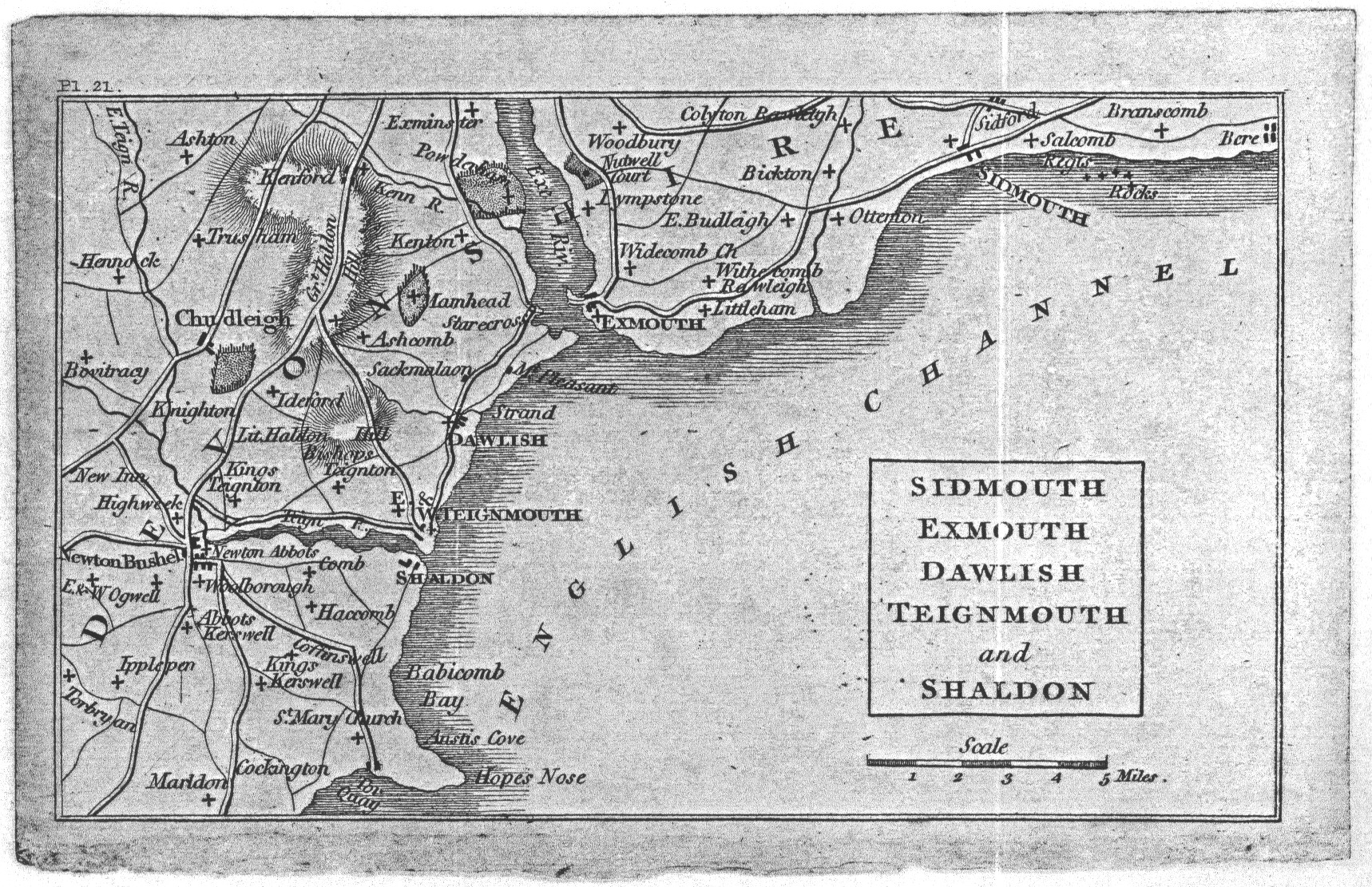
SIDMOUTH EXMOUTH DAWLISH TEIGNMOUTH and SHALDON. (Dd). A sketch map with only main roads named. No imprint, signature. No plate or page number. No hills shown. 


1. 1803 A Guide to all the Watering and Sea Bathing Places
London. Richard Phillips. 1803[1]. BCL, Edin, Leics.


2. 1804 Plate number Pl. 21. (AaOS) and Page number P.200 (EaOS). No hills. 


A Guide to all the Watering and Sea Bathing Places
London. Richard Phillips. 1804[2]. 1806[3].
NLW, Leeds, GL, V&A; V&A, NLS, NLW, B, BRL.

3. 1810 Plate and page number. Three parks now clearly added by Chudleigh: Mamb now Mamhead; and Powderham on west bank of Exe. Hill shading northeast of Chudleigh.


A Guide to all the Watering and Sea Bathing Places
London. Richard Phillips. 1810[4], 1812[5], 1815[6].
BRL, V&A, B, NLW; B, NLW; NLW, B, GL, KB.

4. 1820 Plate number only. Hill shading near Chudleigh named Gt Haldon Hill with Lit. Haldon Hill added just below. Nutwell Court added on east bank of Exe. Extensive revision to roads: turnpike (?) from Teignmouth to Starcross with Sackmalaon (?), Mt Pleasant and Stareross [sic] added; road from Newton Abbot to Torquay upgraded with addition of Coffinswell; road upgraded to Teignmouth from Newton; road north of Nutwell Court; road to Sidmouth with Sidford added.


A Guide to all the Watering and Sea Bathing Places – A New and Improved Edition
London. Longman, Hurst, Rees, Orme and Brown. 1820[7]. B.

5. 1825 No plate or page number. 

A Guide to all the Watering and Sea Bathing Places
London. Longman, Hurst, Rees, Orme and Brown. 1825, 1830[8]. GL; KB.


[1] Has an advertisement dated May 31, 1803. Usually iv plus 434 pages. Various pages misnumbered (e.g. 157 and 920 for 175 and 320).
[2] Now has 450 pages plus a number of extra pages inserted at certain sections making 466.
[3] Now has 500 pages. An advertisement after title page is dated 1806.
[4] Now has 528 pages. An advertisement after title page is dated 1810.
[5] Publisher’s boards are dated 1812.
[6] Now has 560 pages.(pp. 447-470 twice with different text). A copy is recorded in French at Wellcome Library.
[7] Now has 486 pages. Both the 1825 and 1829 editions have 3 more pages at 489.
[8] Last date in text is 1829 (p. 340) but population figs. are for 1821.


Monday, 1 August 2022

E Culverwell / Richard Lethaby

(Peter Orlando Hutchison) 

This simple sketch map of the town of Sidmouth is known in two states, but in works separated by nearly twenty-five years. It was originally printed in The Sidmouth Directory, September 28th, 1869, published by Richard Lethaby (on the first of every month)[1]. The second version of 1894 was included in issues of the eighth edition of P O Hutchinson‘s guide to Sidmouth[2]. The map was incorrectly ascribed to Culverwell in the First Edition of Tourist Maps.

Originally appearing in 1857 as A New Guide to Sidmouth and the Neighbourhood, Hutchinson’s guide was reissued from 1862 as A Guide to the Town and Neighbourhood of Sidmouth. For the 8th edition a new title was chosen and this, much earlier, map included. This sketch map appears in all paperback copies of this edition inspected. One hardback edition at Devon Archives also includes a much later, and lithographically reproduced, version of a map by Wallis[3]. The small Sidmouth plan was obviously pasted in at a much later date.

E Culverwell and Sons had premises on Fore Street, Sidmouth, where they were active as booksellers, stationers, bookbinders and newsagents according to advertising in the guide. They were a typical seaside business also selling fancy goods and fishing tackle as well as operators of a circulating library of some 6000 books. They were advertising a Map Twenty Miles Round Sidmouth for ninepence. This was probably the Wallis map described above. They possibly took over old stock and had lithographs prepared.

Although the Wallis map (which accompanies the sketch map in the Devon Archives copy) is dated 1836, the two maps could well have been brought together later, ie this might be a much later map. The second state has additions such as road names for Station Road and Alexandria Road: these were named for the arrival of the railway with the opening of the station in 1874 and in commemoration of the battle of Alexandria and renamed circa 1882.For the Ninth Edition (and later) Culverwell included the Wallis map described above (in hardback edition) as well as a very crude town map (in paperback version). The author has two copies of the Ninth Edition, however, the two covers are distinctly different. The page size is fractionally larger on one copy (8 mm and 5 mm h x w) although the guide book text is identical. There are no title pages, the paperback cover bearing title an contents (with different maps described as being present). This was very possibly published post-1901.

Size: 160 x 220 mm.  Scale Of 880 Yards Or Half A Mile (9  = 83 mm).                                                                        

MAP OF THE TOWN OF SIDMOUTH (CeOS). Plain sketch map of Sidmouth area. Printed on yellow paper and pasted in to accompany larger map (see text).

The area covered is from The Sea (Ae) as far as Arcot House and Livorna Cottage (Ee). There is no border but the scale bar is just below trimmed edge with scale explanantion below the scale line. Special houses are added in a rather crude script, e.g. Broadway. No railway. 

1. 1869            Map Of Sidmouth issued in        

                        Sidmouth. The Sidmouth Directory. 1869.   


          Map Of Sidmouth – bound with second map.  DevA.


2. 1894   Title removed. At the top of the map is a note To Golf Links & Salter’s Cross (i.e. would have been lost if original map was in fact trimmed) and a little below that is the scale bar with nine markings but no explanantion. Broadway becomes The Manor (with Lodge on main road).The railway is shown finishing on the Exeter and Ottery road, named Station Road in front of The Manor. Additional extra information in tidy script, e.g. The Alma and Foot Bridge (Ae). Illustrated. 

 An Illustrated Guide to the Town and Neighbourhood of Sidmouth; ... Eighth Edition  

Sidmouth. E Culverwell. (1894). BL, DevA. 


[1] It is illustrated in Peter Orlando Hutchison of Sidmouth, Devon 1810-1897; by Catherine Lineham; private printing; (1983). See p. 19. Source not known but probably Sidmouth Library.

[2] See Hutchinson 2 and 3 for details of the earlier maps he used.

[3] This copy is found pasted in as the inside endpaper to a small booklet enclosing a second, larger folding map first published in 1822 by J Wallis (c.f.) but published here by J Harvey and dated 1836 (see Wallis state 2). It is on yellow paper .

Wednesday, 3 November 2021

 Cassell & Co. Ltd

Cassell 6 - Guides to Sidmouth

The Day Brothers were Sidmouth proprietors with premises in the High Street. They advertised themselves as high class stationers, booksellers, newsagents etc. and were the office of the Sidmouth Observer and visitor’s list; Published every Wednesday, price one penny. They published a guide to Sidmouth in 1888 or 1889; Rambles Round About Sidmouth – being a guide to the pretty walks and favourite drives of this fashionable health resort. This work was written and compiled by C D S and was available as a paperback for 6d. This guide is relatively scarce and was possibly not a commercial success, which would explain its rapid replacement. The map in this work was taken from the W & A K Johnston map and covered a wide area surrounding Sidmouth.

In 1894 Macvean and Williams published their guide to Sidmouth. As they note in the preface, much of the content was the work of P O Hutchinson, local historian and writer of works on Sidmouth and environments. The work was issued in attractive original paper-covered printed boards and included a one-page map as well as 6 photographic plates. This book seems to have replaced the guide Rambles Round Sidmouth publshed just a few years before but with a smaller portion of the same W & A K Johnston map. The map being once again a transfer of the plates of Johnston’s Modern Map of England and Wales but now in colour. 

Cassell / Day Brothers 

Size: 192 x 256 mm.                        English Miles 69.16 – 1 Degree (20 = 92 mm). 

PUBLISHED BY DAY BROTHERS, WITH THEIR GUIDE TO SIDMOUTH above top border. Signature: Engraved by W & A K Johnston. Edinburgh & London. Detailed map of east Devon with parts of south Somerset and west Dorset; Sidmouth centrally. Barnstaple (top left) and Castle Cary (top right) with coast of Devon and Dorset from Torquay to Portland. Railways complete to 1888. 

1. 1889            Rambles Round About Sidmouth  Sidmouth. Day Brothers. (1889).      KB.


2. 1894           Map title now SIDMOUTH AND SURROUNDING DISTRICT. (Ee) with scale bar below. Signature: Engraved by W & A K Johnston. Edinburgh & London. (EeOS). Map shows a smaller area north and east of Tor Bay including Dulverton and Taunton to Lyme Regis. Size: 165 x 120 mm. English Miles (5 + 10 = 55). 

The English Riviera: a guide to Sidmouth; with remarks on its history, climate, amusements by Neil Macvean and Leonard Williams      

Sidmouth. Day Bros. 1894.      DevA, KB, [NDL], [Exm]. 


 Edward Croydon 4 Shortly after the arrival of the South Devon Railway into Teignmouth, Edwad Croydon published a detailled plan of the town...