Posts

Showing posts with the label James Neele
Image
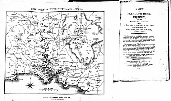
  Samuel and James Neele   Neele 2 The first guide to Plymouth is attributable to Henry Woollcombe , attorney-at-law resident in Frankfort Street, Plymouth and a freeman of the Borough. He was the founding member of the Plymouth Institution which was formed in 1812. He laid the foundation stone of the Athenaeum in 1812 which became the institutions new home. Although his A View Of Plymouth-Dock, Plymouth and the adjacent country contained only one map when first issued, further maps were added for editions of The Tourist's Companion; and The Stranger’s Guide when they appeared post-1823 although this Neele map was maintained (see Cooke 1 and 2). The later guides are the work of John Sanford. Size : 175 x 210 mm.  Scale of Miles (6 = 37 mm). ENVIRONS OF PLYMOUTH, AND DOCK. Imprints (CeOS): Plymouth Dock, Published by Granville & Son 1812 (sic) with Entered at Stationers Hall (below). Signature: Neele, sc, Strand (EeOS). A plain two line border. There is a c...
Image
Samuel and James Neele   Neele 1 Samuel and James Neele   were active from the 1790s to early 1800s. One or other of the Neeles engraved two of the plans included in Charles Vancouver's   work, A General View of the Agriculture of the County of Devon   and other county volumes in the same series have county maps signed Neele (see B&B 70 ). Other county maps of Devon executed by the Neeles are known from 1803 (Wilkes, s ee B&B 64 ), and 1819 ( B&B 86 ). The Beauties of Sidmouth Displayed   is attributed to Edmund Butcher   (1757-1822), a Unitarian minister. Poor health forced him to retire to Sidmouth, where he lived for many years producing sermons and the local guide. In 1805 he wrote An Excursion from Sidmouth to Chester   published by Symonds and Woolmer   and this may have encouraged him. Consequently, although the first edition of Sidmouth Displayed , ... being a descriptive sketch of its situation, salubrity, and picturesque s...