Posts

Showing posts with the label Stranger´s Guide
Image
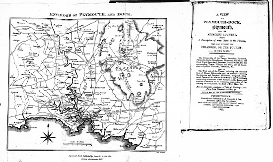
  Samuel and James Neele   Neele 2 The first guide to Plymouth is attributable to Henry Woollcombe , attorney-at-law resident in Frankfort Street, Plymouth and a freeman of the Borough. He was the founding member of the Plymouth Institution which was formed in 1812. He laid the foundation stone of the Athenaeum in 1812 which became the institutions new home. Although his A View Of Plymouth-Dock, Plymouth and the adjacent country contained only one map when first issued, further maps were added for editions of The Tourist's Companion; and The Stranger’s Guide when they appeared post-1823 although this Neele map was maintained (see Cooke 1 and 2). The later guides are the work of John Sanford. Size : 175 x 210 mm.  Scale of Miles (6 = 37 mm). ENVIRONS OF PLYMOUTH, AND DOCK. Imprints (CeOS): Plymouth Dock, Published by Granville & Son 1812 (sic) with Entered at Stationers Hall (below). Signature: Neele, sc, Strand (EeOS). A plain two line border. There is a c...
Image
William  Henry Maddock William Henry Maddock was a printer, engraver and lithographer in Plymouth and appears to have been active from circa 1848 to the mid-1880s. His only known publishing venture would seem to be the map below, dated 1848, and there may have been a reprint in 1853 (see Brockett). Although there is no address on the map below, Maddock was at 32 Frankfort Street 1852-56 but in 1890 the address was 86 Treville Street. He seems to have been a specialist lithographer and as well as printing the three maps listed below also printed two for  John Heydon  of the same area; he also lithographed a map of Exeter for Jewitt - a Plan Of The City Of Exeter appeared in a guide book to the Agricultural Exhibition in Exeter in 1850 (published by H. J. Wallis, Exeter, and R. Lidstone, Plymouth) and which bears the signature of Maddock & Balderston Lithographers, 17, Bedford St Plymouth ; and a Map Of Salcombe, Kingsbridge, And Surroundings for James Fairweather ...