Showing posts with label Ward & Lock. Show all posts

Sunday, 8 October 2023

 WARD & LOCK 

Ward & Lock 12 - South Devon and Dartmoor


Size: 320 x 450 mm. English Miles (4 = 30 mm).

SOUTH DEVON AND DARTMOOR (Ee). Imprint: WARD, LOCK & Co LTD, WARWICK HOUSE, SALISBURY Sq LONDON (CeOS). Signature: G. Philip & Son, London. (EeOS).

Covers the area from Whitsand Bay and Lifton (west) to Seaton Bay (east) and Colyton (Ea): includes Okehampton and Exeter. This was a transfer from a section of the large map produced by Ernest George Ravenstein, Philip's Topographical Map of England & Wales for George Philip in 1899 (B&B 179).

1. 1897 A Pictorial and Descriptive Guide To Torquay, Paignton, Dartmouth, Totnes ... Third Edition
London, New York and Melbourne. Ward Lock & Co. Ltd. (1900[1]). KB.


 RETURN to Catalogue of Maps 


NOTES:

[1] Advert section is dated 1900-1901, adverts dated 1900.

  WARD & LOCK 

Ward & Lock 11 - South East Devon ....


Size: 145 x 190 mm. English Miles (4 = 32 mm).

SOUTH EAST DEVON – THE AXE TO THE TEIGN (Ee). Imprint: WARD, LOCK & Co LTD, WARWICK HOUSE, SALISBURY SQ, LONDON (CeOS). Signature: G. Philip & Son, London & Liverpool. (EeOS).

1. 1898 A New Pictorial and Descriptive Guide To Teignmouth, and the South Devon Coast...
London, New York, and Melbourne. Ward, Lock and Co., Ltd. (1898), (1899). DevA.

A New Pictorial and Descriptive Guide To Sidmouth, Seaton … Devon
London, New York, and Melbourne. Ward, Lock and Co., Ltd. (1899). BL.

A New Pictorial and Descriptive Guide To Dawlish
London, New York, and Melbourne. Ward, Lock and Co., Ltd. (1898). BL.

A New Pictorial and Descriptive Guide To Exmouth, Budleigh Salterton, and the South Devon Coast from the Axe to the Teign
London, New York, and Melbourne. Ward, Lock and Co., Ltd. (1898). BL.

A New Pictorial and Descriptive Guide To Exeter
London, New York, and Melbourne. Ward, Lock and Co., Ltd. (1898). BL.

 RETURN to Catalogue of Maps 


 WARD & LOCK 

Ward & Lock 10 - Plan of Exeter


Size: 140 x 190 mm. Scale of 1/4 Mile (1/4 = 31 mm).

PLAN OF EXETER (Ee). Imprint: WARD, LOCK & Co LTD, WARWICK HOUSE, SALISBURY SQ, LONDON (CeOS). Signature: George Philip & Son, London & Liverpool. (EeOS).

1. 1898 
A New Pictorial and Descriptive Guide To Exeter
London, New York, and Melbourne. Ward, Lock and Co., Ltd. (1898). BL, DevA.

A New Pictorial and Descriptive Guide To Teignmouth
London, New York, and Melbourne. Ward, Lock and Co., Ltd. (1898). BL.

A New Pictorial and Descriptive Guide To Exmouth
London, New York, and Melbourne. Ward, Lock and Co., Ltd. (1898). BL.

A New Pictorial and Descriptive Guide To Dawlish
London, New York, and Melbourne. Ward, Lock and Co., Ltd. (1898). BL.

A New Pictorial and Descriptive Guide To Sidmouth
London, New York, and Melbourne. Ward, Lock and Co., Ltd. (1899). BL.

A New Pictorial and Descriptive Guide To Exeter Second Edition...
London, New York, and Melbourne. Ward, Lock and Co., Ltd. (1900). DevA.


 RETURN to Catalogue of Maps 


 WARD & LOCK 

Ward & Lock 9 - Plan of Ilfracombe


Size:140 x 230 mm. Scale of Yards (200 = 55 mm).

PLAN OF ILFRACOMBE (Aa). Imprint: WARD, LOCK & Co LTD, WARWICK HOUSE, SALISBURY Sq LONDON (CeOS). Signature: G. Philip & Son, London & Liverpool. (EeOS).

Covers the area from Torrs Park and White Pebble Bay (west) to Rapparee Cove (east) and including the station (Be).

1. 1897 A New Pictorial and Descriptive Guide To Bideford, Clovelly, Hartland and North West Devon
London, New York and Melbourne. Ward, Lock & Co. Ltd. (1897). BL, TM.


 RETURN to Catalogue of Maps 


 WARD & LOCK 

Ward & Lock 8 - Teignmouth


Size: 205 x 230 mm. Scale (220 yards = 40 mm).

TEIGNMOUTH (Ee). Sea area not coloured. Pier labelled Teignmouth Pier. No road bridge. Simple north point.

1. 1892
Ward & Lock’s Pictorial and Historical Guide To Torquay, Teignmouth, Dawlish, Dartmouth, Totnes ...
London, New York, Melbourne and Sydney. Ward, Lock and Bowden, Ltd. (1897). DevA.

2. 1897 Sea areas coloured green. More elaborate compass point.

A New Pictorial and Descriptive Guide To Torquay, Paignton, Dartmoth, Totnes ...
Torquay. E L Seeley. (1897). P[1].

A New Pictorial and Descriptive Guide To Torquay, Paignton, Dartmoth, Totnes ...
Torquay. Andrew Iredale. (1897). TQ[2], KB.

A Pictorial and Descriptive Guide To Torquay, Paignton, ...Second Edition
London, New York and Melbourne. Ward, Lock and Co., Ltd. (1898). KB.

A New Pictorial and Descriptive Guide To Torquay, ...
London, New York and Melbourne. Ward, Lock and Co., Ltd. (1899). DevA.

3. 1900 Imprint: WARD, LOCK & Co LTD, WARWICK HOUSE, SALISBURY SQUARE EC (CeOS). Teignmouth Pier becomes simply Pier. Directions added to roads near border (To Newton Abbot and To Dawlish). Title panel also coloured (green). Road bridge added. 

A Pictorial and Descriptive Guide To Torquay, Paignton, ...Third Edition
London, New York and Melbourne. Ward, Lock and Co., Ltd. (1900). KB.


 RETURN to Catalogue of Maps 


NOTES:

 [1] Seen at a book fair in Holland and the maps were missing. Advertising section dated.

[2] Map of Torquay is missing.


 WARD & LOCK 

Ward & Lock 7 - Plymouth, Devonport and Stonehouse


Size:140 x 220 mm. Scale of Yards (1000 = 35 mm).

PLYMOUTH, DEVONPORT AND STONEHOUSE (De). Signature: G.Philip & Son, 32 Fleet Street. (EeOS). 

1.1888 

Ward And Lock's Pictorial and Historical Guide To South Devon
London. Ward Lock & Co. (1888). KB.

Pictorial and Descriptive Guide To Plymouth, Stonehouse, And Devonport ...
London. Ward, Lock & Bowden Ltd. (1895). KB.

Pictorial and Descriptive Guide To Plymouth, Stonehouse, And Devonport ...
London. Ward, Lock & Bowden Ltd. (1896). DevA.

2.1897 Map now in colour. Signature deleted. Imprint now: Ward, Lock & Co., Ltd. London (CeOS). Railway extended to edge of map and to Stonehouse Pool and siding towards Saltash Road (Ca).

A New Pictorial and Descriptive Guide To Plymouth, Stonehouse, And Devonport
London. Ward Lock & Co. (1897), (1898). E; DevA.

A Pictorial and Descriptive Guide To Plymouth, Stonehouse, Devonport and South-West Devon Second Edition
London, New York & Melbourne. Ward Lock & Co. Ltd. (1899). BL.
    

 RETURN to Catalogue of Maps 


 WARD & LOCK 

Ward & Lock 6 - Exeter


Size:140 x 200 mm. Scale of ¼ Mile (40 mm).

EXETER (Ee). Signature: G. Philip & Son, Fleet Street. (EeOS).

1. 1887 
Ward And Lock's Pictorial and Historical Guide To North Devon
London. Ward Lock & Co. (1887). KB.

Ward And Lock's Pictorial and Historical Guide To South Devon
London. Ward Lock & Co. (1888[1]). DevA, KB.
      

 RETURN to Catalogue of Maps 


[1] Advert section is dated 1888.


 WARD & LOCK 

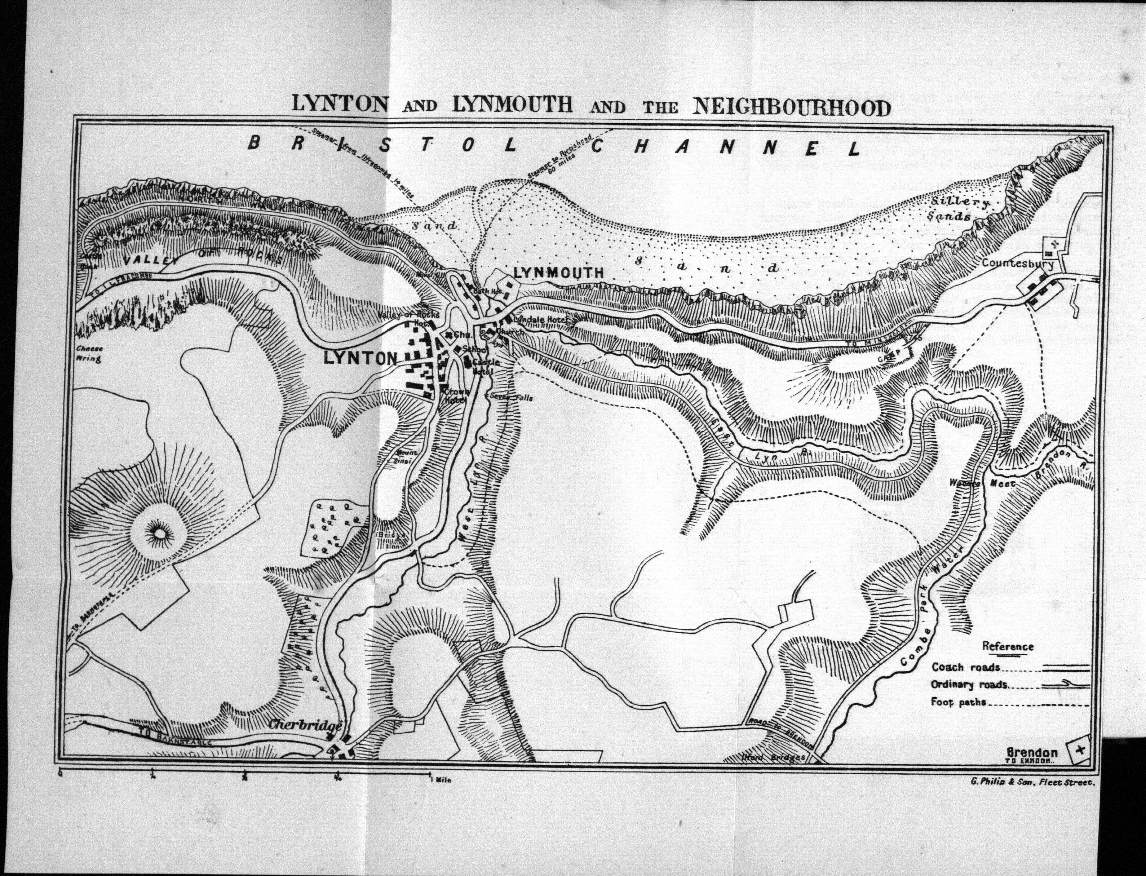
Ward & Lock 5 - Lynton and Lynmouth and the Neighbourhood


Size:140 x 230 mm. Scale (1 = 83 mm) Mile.

LYNTON AND LYNMOUTH AND THE NEIGHBOURHOOD (CaOS). Reference includes Coach Roads, Other Roads and Foot paths. Signature: G. Philip & Son, Fleet Street. (EeOS).

1. 1886 
Ward And Lock's Historical and Pictorial To Lynton, Lynmouth, Minehead etc.
London and New York. Ward, Lock & Co. (1886). BL.

Ward And Lock's Pictorial and Historical Guide To North Devon
London. Ward, Lock & Co. (1887). KB.

Ward And Lock's Historical and Pictorial To Lynton, Lynmouth, Minehead etc.
London, New York and Melbourne. Ward, Lock & Bowden Ltd. (1890). KB.

Pictorial and Descriptive Guide To Lynton, Lynmouth, Minehead etc.
London, New York and Melbourne. Ward Lock & Bowden Ltd. (1894). DevA.


 WARD & LOCK 

Ward & Lock 4 - Ilfracombe

This map of Ilfracombe was replaced by 1897 by a new map (see Ward & Lock 9).


Size:140 x 230 mm. Scale of Yards (500 = 55 mm).

ILFRACOMBE (Ce). Signature: G. Philip & Son, Fleet Street. (EeOS).

1. 1887 
Ward And Lock's Pictorial and Descriptive Guide To North Devon
London. Ward, Lock & Co. 1887. DevA[1].

Ward And Lock's Pictorial and Historical Guide To North Devon
London. Ward, Lock & Co. (1887). KB.

A New Pictorial and Descriptive Guide To Ilfracombe, Barnstaple and North-West Devon 
London, New York & Melbourne. Ward, Lock & Co., Ltd. (1897). BL.


NOTES:


[1] Map tightly bound, it is not possible to read the signature. 


WARD & LOCK 

Ward & Lock 3 - Neighbourhood of Dawlish and Teignmouth


Size: 110 x 92 mm. No scale.

NEIGHBOURHOOD OF DAWLISH AND TEIGNMOUTH (Ca). No imprint.

Simplistic map of coastline from Starcross (Ea) and all the coastline as far as the Mouth of the Teign (Be). Key includes Footpaths.

1. 1884 Ward And Lock's Pictorial and Historical Guide To Torquay, Teignmouth, Dawlish, Dartmouth, Totnes and Other South Devon Watering Places
London and New York. Ward, Lock and Co.. (1884). BL

Ward And Lock's Pictorial and Historical Guide To Torquay, ....
London, New York and Melbourne. Ward, Lock and Co., Ltd. (1886). NA, MW.

Ward And Lock's Pictorial and Historical Guide To South Devon
London. Ward, Lock & Co. (1888). DevA, KB.

Ward And Lock's Pictorial and Historical Guide To Torquay, ....
London, New York. Ward, Lock and Co. (1889). KB.

Ward And Lock's Pictorial and Historical Guide To Torquay, ....
London, New York and Melbourne. Ward, Lock and Co., Ltd. (1892). DevA.


 WARD & LOCK 

Ward & Lock 2 - Torquay, Dartmouth, Totnes &c

Size: 140 x 92 mm. Scale (2 = 18 mm) Miles.

TORQUAY, DARTMOUTH, TOTNES &c (Ae). No imprint.

Fairly simplistic map of coastline from Teignmouh (Ea) and all the coastline as far as Dartmouth (Ce). Key includes Steam Routes and Coach Routes as well as Footpaths.

1. 1884 Ward And Lock's Pictorial and Historical Guide To Torquay, Teignmouth, Dawlish, Dartmouth, Totnes and Other South Devon Watering Places
London and New York. Ward, Lock and Co.. (1884). BL

Ward And Lock's Pictorial and Historical Guide To Torquay, ....
London, New York and Melbourne. Ward, Lock and Co., Ltd. (1886). NA, MW.

Ward And Lock's Pictorial and Historical Guide To South Devon
London. Ward, Lock & Co. (1888). DevA, KB.

Ward And Lock's Pictorial and Historical Guide To Torquay, ....
London, New York. Ward, Lock and Co. (1889). KB.

 WARD & LOCK 

Ward & Lock 1 - Torquay

The map of Torquay was used in guides from 1884. It was replaced by a better map, already being used by Henry Besley, from 1897 (see Besley 5).


Size: 148 x 205 mm. No scale.

TORQUAY (Ae). with north star above (Ad). Printer's imprint: A S CATTELL & Co. ENG. (Ee). Note Torquay To face p.36 (AeOS).

Fairly simplistic map of Torquay from Torre Station (Aa) to St. Marychurch (Ca) and all the coastline. Interesting note (Cc) – Go for view of town.

1. 1884 


Ward And Lock's Pictorial and Historical Guide To Torquay, Teignmouth, Dawlish, Dartmouth, Totnes and Other South Devon Watering Places
London and New York. Ward, Lock and Co.. (1884). BL[1].

Ward And Lock's Pictorial and Historical Guide To Torquay, Teignmouth, Dawlish, Dartmouth, Totnes and Other South Devon Watering Places
London, New York and Melbourne. Ward, Lock and Co., Ltd. (1886). NA, MW.

Ward And Lock's Pictorial and Historical Guide To South Devon
London. Ward Lock & Co. (1888). DevA, KB.

Ward And Lock's Pictorial and Historical Guide To Torquay, ....
London, New York. Ward, Lock and Co. (1889) KB.

NOTES:


[1] Note: most BL copies (this is BL 010347.de.168) are dated one year after publication as their dating seems to be based on accession date. Guides did not have dated title pages, bust most advertising sections either have a year (here 1884 for example), a Series 189x-9y at bottom of advertising page or railway adverts are dated. These dates have been used here.

 WARD & LOCK

Ward and Lock started their own firm on Midsummer's Day 1854. The Locks were an influential Dorchester family and George Lock's father had married Eliza Galpin making George Lock (1832-1891) first cousin to Thomas Dixon Galpin, later to make his name with Cassell, Petter and Galpin. Ebenezer Ward (1819-1902) was a manager for the Illustrated London News publishers' book business. The two were introduced by Thomas Galpin and Ward Lock was launched with a £1000 loan from George Lock senior, the articles of partnership being signed June 23rd 1854. After initial friendly[1] relations and support, contact between the two cousins was broken when Galpin and his partner, George William Petter, took over Cassell's to found a rival business partnership. From 1891 until c.1897 James Bowden was a partner and the company traded under the name Ward, Lock and Bowden Ltd.


Ward and Lock guides first appeared in 1886-87 and included a number of small maps of towns or areas. The first two guides known covered North and South Devon and had maps by various printers, but by the time the individual regional guide books appeared most of the maps were being prepared and printed by G Philip and Son. However, Henry Besley had published maps of North Devon and of South Devon and Dartmoor for his Route Book Of Devon 1857/1858. These two maps were first used in both Besley’s Route Book and his North and South handbooks until c.1880, and were subsequently included by Ward and Lock in their Pictorial Guides. These were replaced towards the end of the century by a new map produced by George Philip & Son: this was a section taken from the large map produced by Ernest George Ravenstein, Philip's Topographical Map of England & Wales for George Philip in 1899 (B&B 179). This, in turn, was replaced in the early twentieth century by a map of South Devon engraved by Bartholomew.

The two Ward & Lock guides for North and South Devon seem to have only been issued once but a number of subsequent titles covered parts of Devon; Bideford (from approx. 1894); Dartmoor (1895); Dawlish (1899); Exeter (1895); Exmouth (1899); Ilfracombe (1896); Lynton and Lynmouth (1890); Plymouth (1895); Sidmouth (1899); Teignmouth (1898); and Torquay (1886).[2]

In addition to the maps listed here, there was also a very small Plan of Merivale Antiquities (57 x 79 mm) which can be found embedded in text in the Pictorial and Historical Guide To Dartmoor (1897) published by Ward, Lock & Bowden. Ward & Lock also used a map prepared by Besley (see Besley 5) of Torquay in their New Pictorial and Descriptive Guide To Torquay.

Between 1884 and 1897, Ward & Lock produced 12 separate maps (click title to access page):


NOTES:

[1] Edward Liveing; Adventure in Publishing – The House of Ward Lock 1854-1954; Ward, Lock & Co. Ltd; 1954.
[2] The internet site for Ward & Lock enthusiasts: www.wardlockredguides.co.uk. Some dates have been changed on evidence of volumes inspected.

 Edward Croydon 4 Shortly after the arrival of the South Devon Railway into Teignmouth, Edwad Croydon published a detailled plan of the town...