Posts

Showing posts with the label Gossipy Guide
Image
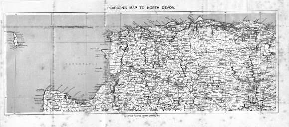
ARTHUR PEARSON   Charles Arthur   Pearson produced a series of Gossipy Guides   at the end of the 19 th century. Like the Ward and Lock series of guides they were full of photographic material in a handy pocket size. Two guides were produced covering Devon: Guide to Ilfracombe and District   (cover title; number 4 in the series); and Guide to South Devon   (number 8 in the series). Both volumes were published 1900-1901. Pearson took maps from different sources to include in his two Devon guides. The map of South Devon included in that guide was a transfer of Bartholomew’s   map (see Bartholomew Imperial 8): however, the map of North Devon is taken from the plates prepared by George Ravenstein   for George Philip   in 1899. The scale reveals that this is a Philip’s map: the scale of 1:200,000 was first used for Philip’s 10-sheet Road Map of England & Wales . Another local trader also used transfers of this map to produce a folding map: Va...
Image
  John Bartholomew – The Imperial Map   Among the earliest of major cartographic works of John Bartholomew   II (1831-1893) was his engraving of the Imperial Map of England & Wales ,   published in 1868. Although originally printed on 16 sheets covering England and Wales from north to south [1] it was not long before both county and regional maps were being prepared from the plates. Archibald Fullarton was the publisher of the Imperial Map and it was issued both in book format and as separate sheets (from which it would be possible to form a wall map). Shortly after the Imperial Map first appeared both W H Smith and A & C Black were offering copies of the same sheets under their own imprints. Black’s offered a New Large Map of England & Wales   in 16 sheet. About 1890 W H Smith offered the Cyclist’s Road Map of England & Wales in 16 sheets from the Ordnance Survey. In addition Houlston and Wright , later Houlston & Sons , were offering...
Image
 John Bartholomew 8 -  for Charles Pearson   Charles Arthur   Pearson produced a number of Gossipy Guides   at the beginning of the 20th century. Styled along the lines of the Ward and Lock series of guides they were full of photographic material in a handy pocket size. The two guides relating to Devon were the Guide to Ilfracombe and District (cover title; number 4 in the series)   and Guide to South Devon (number 8 in the series).   Both British Library volumes have accession dates of 1901. It is interesting that Pearson took maps from different sources to include in his two Devon guides. The map of South Devon included in the South Devon Guide was a transfer of Bartholomew’s map: however, the map of North Devon is taken from the plates prepared by Ravenstein for George Philip & Son   in 1899. The scale reveals that this is a Philip’s map (see Pearson 1 ) .   Bartholomew Imperial Map 8 (Pearson)   Size: 257 x 385 mm. ...