Showing posts with label guide. Show all posts

Friday, 2 September 2022

T  & A  Mortimore / Mortimer Bros. 

T & A Mortimer were proprietors of the Totnes Times and authors of books of local interest: Edward Montague´s The Castle of Berry-Pomeroy, A Novel was published by the Mortimers in 1892[1]. Additionally, they produced guides to the River Dart, Berry Pomeroy and the official guide to Totnes. The map below has first been seen in the The Totnes Times & Dartmouth Gazette Railway and River Dart Guide (1874) and soon after in the Seventh Season edition of the Guide to the River Dart (1875 or76) and in a guide to Berry-Pomeroy Castle published at almost the same time. The Dart guides and the map were still being used in 1902: The author has two copies of Guide to the River Dart, c.1902 (two mentions in text) with this map, one lacking Mortimer Bros. in the imprint.

The short text of the River Dart guide was probably written c. 1869 (Seventh Season in 1875/76)[1]. The text of the 1876 river edition (xvi pages) is identical to the 1874 railway edition but the latter has a different pagination (9-24) and last two pages (and the advert selection) are new. The indication is that the river guide is simply a reprint but the railway guide a newly designed page. The text was expanded in the 1880s to xxiv pages.


 The text (xlviii pages) of Berry-Pomeroy Castle: An Historical and Descriptive Sketch was written circa 1876[2], but the text was revised in the 1880s, and the population figures in the later edition listed below are those of the 1881 census; Berry-Pomeroy  was revised again in the late 1890s (the last date in the text is 1896), and the population figures are now of the 1901 census.

Both guides were written by T and A Mortimore according to the covers and/or the title pages, proprietors of the Totnes Times. However, the imprint on the map found in the later edition of the Berry Pomeroy guide is either T & A Mortimer or T C & A E Mortimer FJI, and the work was later printed at the Times and Western Guardian office. An advert inside the back cover of Guide to the River Dart has Mortimer Bros, Publishers, Totnes, as sellers of both these guides and a guide to Totnes (c.1910). They seem to have used the names Mortimore and Mortimer simultaneously.

The Totnes Times was founded in 1860 with the first edition of the Western Guardian dating to June 1882. A large number of editions were produced for local towns from c.1902, e.g. editions of the Western Guardian for Ashburton, Dartmouth, Newton Abbot and Paignton. From 1903 there was a Brixham issue and from 1904 one for Teignmouth. All of these ceased in April 1968. The two newspapers merged in 1967 to form the Totnes Times Guardian but the name Guardian was dropped in May 1970. The company is still in business today.
A second map can be found in the advertisement section of the earliest Berry-Pomeroy edition. This was for Farley’s Hotel (see Anon- Farley).


Size 215 x 155 mm.  THE SQUARES ARE ONE MILE EACH

RIVER DART. in title lozenge (Ae) just above key and the scale information.  North point showing True North (Ce).

Description.  The area covered is from Torquay Station (EaOS) south as far as Compass Cove (EeOS). Only the western coast of Tor Bay is shown, and this is in the margin, ie outside the right border. Westwards the map stretches as far as Totnes (Ab). Berry Pomeroy is prominent. River Dart is shown clearly. Paignton spelt incorrectly.  

1. 1874   The Totnes Times & Dartmouth Gazette Railway and River Dart Guide 

               Totnes. T & A Mortimore. (1874). Bod.


2. 1876    Imprint added: Printed and Published by T. and A. MORTIMORE, Proprietors of the Totnes Times. (CeOS). Illustrated above.


Guide to the River Dart:A Descriptive Sketch – Seventh Season
Totnes. T & A Mortimore. (1875-76).
[Bod, CUL, NLS,] KB.


                 Berry-Pomeroy Castle:An Historical and Descriptive Sketch
Totnes. T & A Mortimore. (1876).   BL, [CUL, TCD, Bod], TQ, KB.


                 Guide to the River Dart:A Descriptive Sketch
Totnes. T & A Mortimore. (1880), (1885).      [DevA].


3. 1892     Imprint: Mortimer Bros., "Times" and "Western Guardian" Steam Printing Works, Totnes. (CeOS).  


                 Berry-Pomeroy Castle:An Historical and Descriptive Sketch
Totnes. T & A Mortimer. (1892[2]).                        KB.


                Berry-Pomeroy Castle:An Historical and Descriptive Sketch
Totnes. T & A Mortimer. (1901).                           TQ.


NOTES:

[1] Maxted (Exeter Working Papers, 2015) has six further titles published by the firm between 1876 and 1888 including Edward Windeatt´s historical and descriptive account of St Mary´s Church in Totnes (1876) and James Wilson´s Ashburton: A Poem (1880). Locations of items in [brackets] taken from Maxted. Railway Guide is online at Bodleian Library.
[2]  Population of the parish 1,004 according to 1881 census, the last date in the text is 28th November 1885 (p. 27). However, an advert for Symonds´ Champagne Cyder pasted in at back has a date of October 20th 1892. 

Thursday, 1 September 2022

 Peter Orlando Hutchinson

Self Portrait c.1848**

Peter Orlando Hutchinson moved to Sidmouth with his family in 1825 at the age of 15.[1] Due to ill health he was largely educated at home or at local schools. Later in life he toured widely, visiting America and Canada as well as France and Belgium. He was always a keen historian who kept copious records of his discoveries. The Devon Archives possesses his manuscript notes which comprise at least three drafts of his work; they begin in 1830; were redrafted from 1852; and there are revisions, or a final transcription, written between 1870 and 1880. These include numerous maps and plans, many in manuscript.

The first map below was possibly specially commissioned by the town and was subsequently sold as a separate publication (eg broadsheet) as the imprint suggests. Maps two and three below were produced for inclusion in Hutchinson’s guide book to Sidmouth, originally published as A New Guide to Sidmouth and the Neighbourhood

Richard Lethaby printed and published The Sidmouth Journal and Directory from 1858 until 1885.

Hutchinson 1

Size: 365 x 200 mm. (1 = 111 mm) One Mile.

A map OF THE TOWN AND PARISH OF SIDMOUTH IN THE COUNTY OF DEVON reduced by P. O. Hutchinson, Esqre FROM THE LARGE MAP In the Possession of the LORD OF THE MANOR. (Aa). Signature below this: W. Spreat, lith, Exeter. Imprint: Published and Sold by J. HARVEY, (Library.) Sidmouth. (CeOS). North point with TRUE NORTH (Ea).
Plan of both town – in block style with no details – and the parish of Sidmouth. Very few places are named: Lime kiln, Bickwell and Woolbrook Farms and the Vicarage and a few fields.


1. 1850      Loose sheet

                A map of the Town and Parish of Sidmouth
                Sidmouth. J Harvey. (1850). DevA.


Hutchinson 2 & 3

Maps two and three were produced for inclusion in Hutchinson’s guide book to Sidmouth. This was originally published as A New Guide to Sidmouth and the Neighbourhood and published by Thomas Perry, but reissued as A Guide to the Town and Neighbourhood of Sidmouth from the second edition of 1862 and now published by Richard Lethaby. In the Preface to the third edition Hutchinson writes: The present Edition differs materially from the two preceding. More than half of it has been entirely rewritten. Writing in the Preface to the 7th edition of 1885 he wrote: The later editions have been enriched by the addition of much valuable local matter, contributed by Mr Lethaby himself, the Proprietor and Publisher, and the late Mr James Sutherland.

Culverwell & Sons reprinted the text verbatim for their later editions but did not include these maps. The Eighth Edition included a small sketch map of the town; the Ninth Edition (and later) contained a map published originally by Wallis in 1822 and a crude sketch map of the town.


Hutchinson 2

Size: 130 x 160 mm. No scale.

SIDMOUTH, DEVON AND THE NEIGHBOURHOOD. (CeOS). Signature: P O Hutchinson, fecit in cupro (Ae). Attractively hachured map of Sidmouth and the surrounding area: from Otterton Rock (Ae) across to Weston House Ruins (Ee) and inland as far as Fen Ottery (Ba).

1. 1857      A New Guide to Sidmouth and the Neighbourhood: ... First Edition [2]
                Sidmouth. Thomas Perry. (1857). TQ, DevA, BL[3].

                A Guide to the Town and Neighbourhood of Sidmouth; ... Second Edition
                Sidmouth. Richard Lethaby. (1862). [TQ], [DevA].

                A Guide to the Town and Neighbourhood of Sidmouth; ... Third Edition
                Sidmouth. Richard Lethaby. (1865). BL, KB, DevA.


Hutchinson 3

Size: 235 x 250 mm. (1 = 90 mm) Mile.

A MAP OF THE ENVIRONS OF SIDMOUTH. (Ee). Signature: Stanford's Geographical Establishment. London. (EeOS). Imprint: Published by R Lethaby, Sidmouth. (CeOS). Scale (Be-De). L&SWRy Sidmouth Branch added ending at Railway Terminus.
Sidmouth, centrally, with neighbouring parishes. Attractive hachuring. Harpford Wood (Aa) and Peak Hill (Ad) west to Sidford (Ea) and Salcombe Hill (Ec) eastwards.

1. 1875    A Guide to the Town and Neighbourhood of Sidmouth; ... Fifth Edition [4]
                Sidmouth. Richard Lethaby. (1875). DevA.

                A Guide to the Town and Neighbourhood of Sidmouth; ... Sixth Edition
                Sidmouth. Richard Lethaby. (1879). BL[5].

                A Guide to the Town and Neighbourhood of Sidmouth; ... Seventh Edition
                Sidmouth. Richard Lethaby. (1885). DevA, TQ, KB.


Acknowledgement of self-portrait: Peter Orlando Hutchinson (1810-1897) - Picture credit: Culture24, Public Domain, https://commons.wikimedia.org/w/index.php?curid=27861319

[1] For a short biographical overview of the life of Hutchinson, see Peter Orlando Hutchinson of Sidmouth, Devon 1810 – 1897, by Catherine Linehan, published privately (and undated).

[2] The edition and date of publication is taken from the Preface for the 7th edition. Each preface is dated and later editions list the previous editions.

[3] British Library has 1st edition BL 10368.a.24 and third edition BL 10368.bbb.20.

[4] The fourth edition apperaed in 1868.

[5] British Library has 6th edition BL 10352.e.20; the 8th edition BL 10368.cc.54 has a new map (see Culverwell).

Monday, 1 August 2022

 Arthur Westley 1

 NEW - Please note Westley 1 and 2 are now Cockrem 6 and 7.


Arthur Westley took over much of Edward Cockrem´s stock and rights to publish when Cockrem died in 1872. He was certainly keen to make the most of the tourist trade and general interest as his publishing output shows. One of the maps below still has its original covers and proves that Westley was offering all of the following for sale at the same time: Westley’s Tourist Guide to Torquay & Neighbourhood (certainly later editions of Cockrem’s guide); Westley’s Large Scale Plan of the Town of Torquay at 12 miles to the inch; Westley’s Map of 25 Miles Round Torquay; as well as books of views and also Westley’s Sixpenny Guide to Torquay & Neighbourhood (no known copy survives). His Westley’s Plan of the Town of Torquay at 8 inches to the mile (price 1/-, see below) as well as the same map but with a special index of over 1000 Villas, Terraces, &c. (price 1/6) were clearly later examples of Cockrem´s map Produced to accompany the Torquay Guide (which he continued to sell with amended imprint, see Cockrem 6 and 7).

The map described below was certainly drawn before 1886. It identifies the Great Western Hotel: this was built in 1881 and retained that name until 1885 when it dropped the “Great“ (in 1902 it became the Grand Hotel). The Admiralty Experiment Works are clearly labelled in Chelston: this was the brainchild of the engineer William Froude who designed a huge test bed to experiment with ship hull designs. The test centre started in his house in 1872 but moved to Gosport in 1886.[1] The approximate dating of 1883 also ties in with the imprint. Edward Stanford had premises at 55 Charing Cross until c.1886.[2]

The fact that the map was drawn up by Stanford´s suggests that Cockrem may have commissioned it about the same time as his two smaller maps for the later editions of his Guide to Torquay


Size: 445 x 720 mm (map only). SCALE (1/2 mile = 100 mm) MILE.            

A PLAN OF THE TOWN OF TORQUAY Published by ARTHUR WESTLEY 10, Strand Torquay. Printer's signature: STANFORD LITH, 55 CHARING CROSS, LONDON, S W. (EeOS). Signature: W PARKER, DELT (CeOS). Scale is eight inches to the mile. Grid A to R vertically and 1 to 28 horizontally (to locate dwellings and streets in the list).

The area covered is from Livermead and Shiphay Bridge (west) and to Hope’s Nose and Anstey's Cove (east). Map is coloured to show the various suburbs. Two indexes (Ea) and complete street index below map adding 150 mm to height of sheet. Illustrated.

1.1883             A Plan Of The Town Of Torquay 

Torquay. Arthur Westley. (1883). BL[3], KB[4].

 2.1883             Title, imprint and signature as before. Size is now 640 x 755 mm with panel below adding 150 mm to sheet size (800 x 800 mm complete). Scale bar now 145 mm (1/2 Mile).  

The whole sheet (including the index) is an enlarged copy of the above. However, the eastern side has been cut off and all of Hope’s Nose and Flat Rock and northwards to Anstey’s Cove is now lost (part of the latter sacrificed to include the index list). Hence, the grid is now A to R as before but only 1 to 20. The index has not been changed to exclude Hope Farm at 21L which has been cut off. 

A Plan Of The Town Of Torquay                        

Torquay. Arthur Westley. (1883). BL[5].

 3. 1886     The map is identical to state 1 except that the number 55 has been cleanly erased from the printer's signature.

Cover title simply TORQUAY. Cut, pasted onto linen and folding into 18 sections inside embossed green board covers.

 A Plan Of The Town Of Torquay 

Torquay. Arthur Westley. (1886). KB.


[1] See https://historicgosport.uk/haslar-admiralty-experimental-works/.
[2] Stanford’s moved to 26-27 Cockspur Street and the last date seen on maps with 55 Charing Cross is 1886.
[3] BL Maps 2140.(9.). Rebacked: Original orange paper label cover pasted on reverse; Westley’s Large Scale Plan of Torquay (From the Ordnance Survey), corrected to the Present Time… folding into six unequal sections. Largest section is 510 x 320 mm.
[4] Cover title Westley’s Plan of Torquay. From the Ordnance Survey, Corrected to the Present Time ... Scale 8 Inches To The Mile folding into orange paper covers.
[5] BL Maps 2140.(8.). Rebacked: Original cover pasted on reverse (front only), white paper label (180 x 115 mm) with title Westley’s Large Scale Plan of Torquay (From the Ordnance Survey), corrected to the Present Time ... Scale Twelve Miles to the Inch… folding into six unequal sections. Largest section is 510 x 320 mm.

Wednesday, 3 November 2021

 Cassell & Co. Ltd

Cassell 6 - Guides to Sidmouth

The Day Brothers were Sidmouth proprietors with premises in the High Street. They advertised themselves as high class stationers, booksellers, newsagents etc. and were the office of the Sidmouth Observer and visitor’s list; Published every Wednesday, price one penny. They published a guide to Sidmouth in 1888 or 1889; Rambles Round About Sidmouth – being a guide to the pretty walks and favourite drives of this fashionable health resort. This work was written and compiled by C D S and was available as a paperback for 6d. This guide is relatively scarce and was possibly not a commercial success, which would explain its rapid replacement. The map in this work was taken from the W & A K Johnston map and covered a wide area surrounding Sidmouth.

In 1894 Macvean and Williams published their guide to Sidmouth. As they note in the preface, much of the content was the work of P O Hutchinson, local historian and writer of works on Sidmouth and environments. The work was issued in attractive original paper-covered printed boards and included a one-page map as well as 6 photographic plates. This book seems to have replaced the guide Rambles Round Sidmouth publshed just a few years before but with a smaller portion of the same W & A K Johnston map. The map being once again a transfer of the plates of Johnston’s Modern Map of England and Wales but now in colour. 

Cassell / Day Brothers 

Size: 192 x 256 mm.                        English Miles 69.16 – 1 Degree (20 = 92 mm). 

PUBLISHED BY DAY BROTHERS, WITH THEIR GUIDE TO SIDMOUTH above top border. Signature: Engraved by W & A K Johnston. Edinburgh & LondonDetailed map of east Devon with parts of south Somerset and west Dorset; Sidmouth centrally. Barnstaple (top left) and Castle Cary (top right) with coast of Devon and Dorset from Torquay to Portland. Railways complete to 1888. 

1. 1889            Rambles Round About Sidmouth  Sidmouth. Day Brothers. (1889).      KB.


2. 1894           Map title now SIDMOUTH AND SURROUNDING DISTRICT. (Ee) with scale bar below. Signature: Engraved by W & A K Johnston. Edinburgh & London. (EeOS). Map shows a smaller area north and east of Tor Bay including Dulverton and Taunton to Lyme Regis. Size: 165 x 120 mm. English Miles (5 + 10 = 55). 

The English Riviera: a guide to Sidmouth; with remarks on its history, climate, amusements by Neil Macvean and Leonard Williams      

Sidmouth. Day Bros. 1894.      DevA, KB, [NDL], [Exm]. 


Monday, 1 November 2021

Dr John Gifford Croker

Although the author of the slim volume A Guide to the Eastern Escarpment of Dartmoor is not given and was compiled by “One ...... who oft has “trod” its hill and dale magnificent”, quoting Carrington´s poem the text is generally attributed to John Gifford Croker, a doctor from Bovey Tracey. Completed in May 1851, Croker’s guide was probably the first attempt at a walking guide to the moor. Unlike other works on the moor such as those by Crossing or Rowe’s Perambulations which kept a historical-geographical scientific approach, this work was designed to aid the tourist or the Explorator of Dartmoor.

The volume also includes a large folding map (in full wash hand-colouring) which, given its rather amateur execution, makes it a reasonable guess that Croker also drew this. Although it does give three geological rock formations in its key, one has the feeling that this was just an added extra. There were four publishers listed on the title page but some of them may merely have been retailers and distributors of the work. Roger Lidstone was listed for Devonport and Plymouth, A Holden in Exeter and Kirkman & Thackray in London as well as J E Searle, who also printed the work, and was probably the main publisher.

Dr John G Croker was born 1788 in Bridgwater in Somerset but lived most of his life in Bovey Tracey on the edge of the eastern part of the moor most f his life. He died in 1859 in Ipplepen, only a few miles away. He was a keen naturalist and geologist and a collection of fossils he accumulated is now held at Epsom College. When his medical notes were discovered in 1822 they revealed that he had experimented with vaccinations for whooping cough and smallpox on his own children (and may have locked them in the attic as a form of quarantine).[1]


Size 438 x 325 mm. Scale of Statute Miles (5 miles = 100 mm).

Eastern Escarpment of Dartmoor centre top in “Handwritten” script. No signatures or imprints. There is a key to geological structure (granite, carbonaceous schist and trap sienite) in three colours bottom right and the map is wash-coloured. Scale at bottom (Be-Ce). There is a small compass point (Ea).

The map area extends from Ashburton (De) and Bovey Tracey (Ed) to Cawson Hill (Aa).

1. 1851 A Guide to the Eastern Escarpment of Dartmoor.
Chudleigh. J E Searle. (1851).[2]              BL[3], KB, [NDL], [DevA][4].


[1] This account of Croker´s life is based on the page of Christopher-Andrew-Meadowcroft at genealogy.conm and genuki.org.uk Bovey Tracey.

[2] See text for information on other publishers. A slim volume of only 26 pages, the last page is dated Bovey-Tracey, May, 1851.

[3] BL RB.23.a.22725 (two copies).

[4] The Local Studies Catalogue is confusing and lists 3 copies: 1851 28pp Kirkman & Thackray; c.1852 Kirkman & Thackray; and 1852 41pp. Roger Lidstone.

 Beatrix Feodore Cresswell


According to Tony Gale on the Crediton Area History and Museum Society website Beatrix Feodore Cresswell (1862-1940) produced dozens of publications on a range of subjects between 1889 and the mid-1920s. Her earliest work to appears to be “The Royal Progress of King Pepito”, published by the SPCK in 1889 with illustrations by the well-established Kate Greenaway. At the turn of the century she produced two books for the Homeland Series: Dartmoor and its Surroundings, cf Cary-Cresswell) and Teignmouth; its Histoy and Surroundings (with two maps described below). It was early in the twentieth century that Cresswell got into her stride as a local historian. In 1908 she published, “Architectural Antiquities of Exeter and the Neighbourhood”. Two volumes appeared in 1910; “A Survey of Devon Churches” and “Chained Books and Libraries in Devon Parish Churches”. Much of her historical research appeared in the Transactions of the Devonshire Association; she transcribed a large number of late mediaeval church texts.

The second local work for the Homeland Series to be published before 1901, Teignmouth: Its History & Its Surroundings, was written in 1900 (the Preface is dated) and published the following year. This volume was No. 15 in the Homeland Handbook series and was copiously illustrated by Gordon Home. This book contained two maps: the first was a small sketch plan of Teignmouth on page 27; the second was a large folding map of the area based on the Ordnance Survey map and inserted into a special pocket at the back of the book. This work also has the name of F B Owen on the title page as publisher. He had premises at the Royal Library in Teignmouth and may have simply been the local sales agent.

Cresswell 1 (Teignmouth town)

Size 90 x 145 mm. No scale.

SKETCH PLAN OF TEIGNMOUTH. (CeOS) with no signature or imprint except a very faint C.H.Sc in the corner (Ee). Border right and left is made up of two simple Greek columns.

Description: The area covered is from The Ness and Shaldon in the west and eastwards to include The Grove and the Catholic College. The plan extends northwards just enough to include all of the bridge. Compass (Ae) orientated with North-South just a few degrees off the horizontal.

Cresswell 2

Size 275 x 350 mm. SCALE 1 INCH TO THE MILE.

Teignmouth: with its Surroundings. (CeOS) with scale (in words) immediately below. Notes: PRINTED BY THE HOMELAND ASSOCIATION / 24, BRIDE LANE, FLEET STREET, LONDON, / FOR INSERTION IN / TEIGNMOUTH: ITS PAST HISTORY AND PRESENT INTERESTS (on four lines AeOS) and Taken from the Government Ordnance Survey by special permission of the Controller of Her Majesty's Stationery Office. (EeOS).
Description. The area covered is from just below Torbryan (Be) and Kingskerswell north as far as Trusham (Ba) and Kenton (Ea) and eastwards to the mouth of the Exe.

Both maps found in:

1. 1901 Teignmouth: its History & its Surroundings … by Beatrix F Cresswell
Teignmouth: F B Owen. London: The Homeland Association Ltd. 1901.   BL[1], DevA[2], NDL, TQ, MCL, KB[3].


[1] Paperback BL 10360.p.15/1.
[2] Two copies: one paperback but rebound and map has adverts on reverse; second copy is hardback with plain back folding into pocket at back of book.
[3] Hardback with attractive tooling.


Wednesday, 18 August 2021

 Robert Brindley

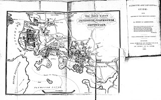
Not much is known of Robert Brindley besides him being the artist and engraver of the map below for The Plymouth, Stonehouse and Devonport Directory in 1830 which was also published by Byers.

William Byers was printer, bookseller and bookbinder with various addresses in Fore Street from 1823 to 1852[1]  although he originally registered his press in 1818 (19/2/1818, DRO Q/S 52). He was the proprietor and publisher of Devonport Independent and Plymouth and Stonehouse Gazette from about 1840 to 1852 and published later editions of A Walk Round Mount Edgcumbe.a popular guide (see Byers / Cooke). He was also one of the leading producers of lithographs of local scenes.

He published the second and subsequent editions of Henry E Carrington‘s The Plymouth and Devonport Guide with issues from 1830 to 1850 (c.f. below and Becker 1). He advertised himself as Bookseller &c to Duke of Clarence 1828-1830 and subsequently as Bookseller etc. to (late) King William IV (up to) 1843. Byers is also noted in Somers Cocks for a number of Devon scenes, some after leading artists such as J D Harding and Louis Haghe, sometimes in association with S Saunders[2]. 

Brindley 

Size: 180 x 243 mm.                                                           Scale of Miles (1 = 76 mm) 1 Mile.

 THE THREE TOWNS OF PLYMOUTH, STONEHOUSE AND DEVONPORTSignatures[3]: Drawn and Engraved by Robt Brindley Architect & Surveyor Devonport (AeOS) and Engraved by Lionel James Pelham London. Scale bar (Ba-Ca) with Scale of Miles below.

Plan of the three towns with Torpoint shown (Aa) and the Breakwater (Ce) and as far as "New line of Road" to the new Laira bridge (Ed).                                                  (E). 

1. 1828          The Plymouth And Devonport Guide ... by Henry E Carrington ... with Lithographic Views by Worsley [4]

                      London: Longman & Co. Devonport: Byers.1828.        FB.


The Plymouth And Devonport Guide ... by Henry E Carrington ... 2nd edition [5]

 Devonport. Byers. 1830                                                                      KB.


                        The Plymouth And Devonport Guide ... by Henry E Carrington ... 2nd edition [6]

                        Devonport. W Byers. 1833.                                                                       KB, BL.


                        The Plymouth And Devonport Guide ... by Henry E Carrington ... 3rd edition

                        London: Longman & Co. Devonport: Byers. (1836).                        [assumed].


                        The Plymouth And Devonport Guide ... by H E Carrington... Fourth Edition [7]

                        London: Longman & Co. Devonport: W Byers. (1840).                          E, KB.


[1] First at 109, Fore Street, Dock 1823; then 32, Fore Street, Devonport 1830-1844; and 116, Fore Street 1850-1852.

 [2] See for example Somers Cocks S.91, S. 97, S.111, S.114.

[3] Both signatures are very badly executed and sometimes virtually illegible.

[4] BL 579.a.40 lacks map; last date 1827 (p.5). Somers Cocks lists an 1829 edition as well as copies for 1837 (probably 4th edition below) and 1843 (see Becker 1).

[5] Bookseller and Printer to HRH The Duke of Clarence. Text has been reset and updated: last date in text is 1828 (p.4, reference to Union Savings Bank).

[6] Bookseller to His Majesty. The 1833 edition is identical to 1830 edition except the Appendix, pp. 291-302, and a final page with list of subscribers (first side) and advert for Byer’s works is lacking. BL copy 10361.a.1 lacks pp. 1-2.

[7] Bookseller to his late Majesty. The last date in text is December 1837 (p.7) and the dedication to King William IV (died June 1838) but there is a note on page 78  that the British Association will honour the town by holding their annual meeting there in 1841; BL dates its copy to 1840 - 10368.aa.22 but this contains a new map by Becker (c.f.). Exeter copy is dated 1837 but probably based on last date in text.

 Edward Croydon 4 Shortly after the arrival of the South Devon Railway into Teignmouth, Edwad Croydon published a detailled plan of the town...