Posts

Showing posts with the label W H Smith
Image
  John Bartholomew – The Imperial Map   Among the earliest of major cartographic works of John Bartholomew   II (1831-1893) was his engraving of the Imperial Map of England & Wales ,   published in 1868. Although originally printed on 16 sheets covering England and Wales from north to south [1] it was not long before both county and regional maps were being prepared from the plates. Archibald Fullarton was the publisher of the Imperial Map and it was issued both in book format and as separate sheets (from which it would be possible to form a wall map). Shortly after the Imperial Map first appeared both W H Smith and A & C Black were offering copies of the same sheets under their own imprints. Black’s offered a New Large Map of England & Wales   in 16 sheet. About 1890 W H Smith offered the Cyclist’s Road Map of England & Wales in 16 sheets from the Ordnance Survey. In addition Houlston and Wright , later Houlston & Sons , were offering...
Image
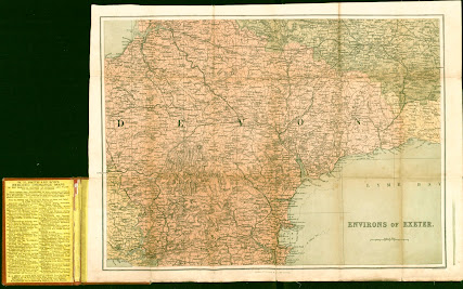
 John Bartholomew –    for W H Smith – SOUTH DEVON II   This is the second map produced by John Bartholomew which seems to represent an experiment in hill shading. Here very subtle tones have been used to render the hills. A copy of North Devon in the same manner has not been seen. This map is only known in one state, and the date can only be conjectured using the railway progression. However, a second copy has been seen (on ebay) which is apparently the same map   but in blue covers with the title The Pocket Series of Touring Maps   published by John Walker & Co., Ltd   of Farringdon House, Warwick Lane, London. The corresponding map of North Devon in this series was that used by W H Smith in approximately 1893: a transfer from the Imperial Map (see Victorian Maps of Devon, Second Edition, entry 150.11b).   Bartholomew – W H Smith 2 Size: 515 x 490 mm.    SCALE 1 : 126,720 - 2 MILES TO AN INCH   (6   = 75 mm). ...
Image
 John Bartholomew –    for W H Smith – SOUTH DEVON I Bartholomew was providing W H Smith and Son with maps from circa 1874, two of the earliest Imperial Map sections being sold as North Devon and South Devon quite soon after the publication of the Imperial Map . However, John Bartholomew was known to be experimenting with hill shading in the 1880s and the Bartholomew records show various printings of the map below in the years 1884-1887 (probably referring to the first one below). Two maps have been found, both executed by the Bartholomew company and both sold in W H Smith covers, and displaying attempts at portraying heights. The first used a very harsh hachuring to achieve hill shading, but the later version uses a very subtle brown tone to give the impression of height (c.f. next entry ). These seem to be the precursors for Bartholomews Reduced Ordnance Survey Maps published in 1895/1896. W H Smith advertised maps of both North Devon and South Devon ...
Image
  John Bartholomew –  Imperial Map 2 W H Smith was   founded c.1820 by Henry Edward   and his brother William Henry (who actually ran   the company). But it was not until Henry’s son, also William Henry (1825-1891), became a partner in 1846 that the firm became the well-known booksellers and stationers. In 1848 he started a newsagent shop at Euston with a concession from the L&NW Railway. This was soon to be converted into a virtual railway book-stall monopoly. The firm soon became the largest newsagent in the country and expanded further into circulating libraries.   William Henry later entered Parliament and became the First Lord of the Admiralty in 1877 (Gilbert & Sullivan’s HMS Pinafore was supposedly based on him). [1] W H Smith used to have an estate in Rewe in east Devon where he had a stable built opposite St Mary the Virgin church for the use of the parishioners so that they could tie up their horses. [2] At the same time as the maps ...