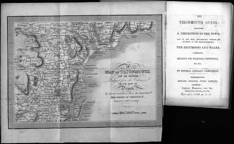
Edward Croydon 2 W Read, who engraved this small map for the Teignmouth Guide, was a line and stipple engraver of portraits, landscapes as well as topographical views after his contemporaries [1] . He also produced 4 or more aquatints after T E Chapman for Aquatint Views of Dawlish published by Jane Gore and J Knighton in Dawlish, c. 1828. In addition he executed at least 4 aquatints after L E Reed which was also published by Croydon c. 1825. See S.76. Size: 175 x 240 mm. Scale of Statute Miles (10 = 58 mm). A MAP OF TEIGNMOUTH and its vicinity Reduced from the Ordnance GRAND MAP OF DEVON By Special Permission from the Right Honble THE BOARD OF ORDNANCE, Granted to Edwd Croydon. (Ee). Engraver’s signature: Engraved by W Read King St, Covt Garden. (CeOS). Piano-key style frame. Coast is shown from Beer Head to the Mew Stone south of Berry Head and inland to Gidley and Modbury. 1. 1826 The Teignmouth Guide Teignmouth. E Croydon. (1826), (1827). D...