Showing posts with label Thorough Guide Series. Show all posts

Thursday, 1 September 2022

Dulau - Thorough Guide series

Dulau (South) 10 

Size: 230 x 310 mm.  Scale of 1/4 Mile (25 mm). 

This map replaces a smaller map (see Dulau (South) 9). 

TORQUAY (De). Signature: J Bartholomew Edinr. Copyright: (AeOS). Scale (Ea).

Description: From Newton Road and Rawlyn Road to Hope's Nose. Graticule 1-11 horizontal and A-I  vertical. References Da-Eb on map with reference numbers. Orange shading. Many additions including new harbour names and shading for cliffs. 

1. 1895   Thorough Guide Series: South Devon and South Cornwall Fifth Edition, Revised                          

             London. Dulau & Co. 1895 (1900).


Dulau - Thorough Guide Series 

Dulau (South) 9 

Size: 150 x 200 mm. Scale of 1/4 Mile (25 mm). 

TORQUAY (Ea). Signature: J Bartholomew Edinr. Copyright: (AeOS). Scale (Ea). Description: From Seaway Lane and Torre Station to Bishopstowe and Meadfoot Sands. 

This map was replaced by a new, larger map in 1895.

1. 1892 
          Thorough Guide Series: South Devon and South Cornwall Fourth Edition, Revised
          London. Dulau & Co. 1892 (1891), 1892, 1892 (1893).


 Dulau - Thorough Guide Series

  Dulau (South) 8 

Size: 90 x 150 mm.   Scale of 1/2 Mile (25 mm). 

SEATON AND THE LANDSLIP (Ae). Signature: J Bartholomew Edinr. Copyright: (AeOS). Note: To face page 18. Scale (Ae). Description: From Seaton beach to Cliff Cottage. 

1. 1891  Thorough Guide Series: South Devon and South Cornwall Fourth Edition, Revised

               London. Dulau & Co. 1892 (1891), 1892.   

2. 1895  Signature: John Bartholomew & Co. Edinr. Overprinted brown colour for carriage roads and footpaths. To face page 20. Illustrated. 

               Thorough Guide Series: South Devon and South Cornwall Fifth Edition, Revised

                London. Dulau & Co.1895.

3. 1895 Signature: J. Bartholomew. Edinr.


               Thorough Guide Series: South Devon and South Cornwall Fifth Edition, Revised

                London. Dulau & Co. 1895 (1900).

 Dulau - Thorough Guide Series

Dulau (South) 7

Size: 155 x 240 mm (as title).  Scale: (4 = 50 mm) Miles.

SECTION MAP No 6 (p.144). Signature: J Bartholomew. Edinr. Scale (Ae).

Description: Area from Stoke Point to Tavistock and Saltash to Princetown (in border). Illustrated. 

1. 1884    Thorough Guide Series: No. VII ... South Devon And South Cornwall.

                London. Dulau & Co. 1884.          


                Thorough Guide Series:  South Devon and South Cornwall Second Edition, Revised 

               London. Dulau & Co. 1885, 1885 (1886), 1885 (1887).     


2. 1889   SECTION MAP No 6 (p.146). Signature: John Bartholomew & Co. Edinr. Scale (Ae). Copyright: (AeOS). Note: Carriage roads etc. (CeOS). Plymouth to Tavistock rail line added. 

               Thorough Guide Series: South Devon and South Cornwall Third Edition, Revised 
                London. Dulau & Co. 1889, 1889 (1890).   

3. 1892   New title: SECTION MAP No. 7. Signature: J Bartholomew. Edinr. Scale moved in from border (approx. Be and Ce). Line in river only below Saltash. More routes on both flanks of Yealm.

                Thorough Guide Series: South Devon and South Cornwall Fourth Edition, Revised
                London. Dulau & Co. 1892 (1891), 1892, 1892 (1893).  

4. 1895    SECTION MAP No. VIII with map number on EP map: MAP VIII (p.150). Scale moved towards border (approx. Ae and Be but higher than state 1, above). No line in river at Saltash. Carriage roads at Antony (Ad) and along Plym to Laira Green.


Thorough Guide Series: South Devon and South Cornwall Fifth Edition, Revised

London. Dulau & Co. 1895.


5. 1900  Carriage roads brown.


Thorough Guide Series: South Devon and South Cornwall Fifth Edition, Revised

London. Dulau & Co. 1895 (1900).


Dulau - Thorough Guide Series           

Dulau (South) 6

Size: 145 x 265 mm.   Scale of ½ Mile (1/2 = 35 mm). 

PLYMOUTH. STONEHOUSE & DEVONPORT (p.138) (De) with scale below. Signature: J Bartholomew. Edinr.

Description: Area from Hamoaze to Catwater and north to Mutley Station. Has Catdown and only Laira Road named leading into Plymouth from Laira Bridge. List of Hotels (Ac) with nine entries. Illustrated.


1. 1884 Thorough Guide Series: No. VII ... South Devon And South Cornwall.
London. Dulau & Co. 1884.

Thorough Guide Series: South Devon and South Cornwall Second Edition, Revised
London. Dulau & Co. 1885, 1885 (1886), 1885 (1887).

2. 1889 Signature:
John Bartholomew & Co. Edinr. Scale (De). Copyright: (AeOS). Graticule 1-7 horizontal; A-D vertical. (EP p.133). List of HOTELS has been expanded to ten and stations as well as important sites included. New railway leads through lime quarries at Catdown. L&SWR line from Devonport & Stonehouse station north.

Thorough Guide Series: South Devon and South Cornwall Third Edition, Revised
London. Dulau & Co. 1889, 1889 (1890).

3. 1892 Signature: J Bartholomew. Edinr. Has Cattedown and Laira Road (leading into Plymouth from Laira Bridge) is now Embankment Road with additional side roads. Workhouse and Hospital added (6A).

Thorough Guide Series: South Devon and South Cornwall Fourth Edition, Revised
London. Dulau & Co. 1892 (1891), 1892, 1892 (1893).

4. 1895 No shading for premises. Tramways brown.

Thorough Guide Series: South Devon and South Cornwall Fifth Edition, Revised
London. Dulau & Co. 1895.

Thorough Guide Series: South Devon and South Cornwall Fifth Edition, Revised
London. Dulau & Co. 1895 (1900).


 Dulau - Thorough Guide Series

Dulau (South) 5 

Size: 175 x 330 mm. Scale: (4 = 50 mm) Miles (Ae). 

SECTION MAP No. 5 (p.90). Signature: J Bartholomew. Edinr. Scale (Ae). Description: Area from Tavistock north to Okehampton (station) and east to Chudleigh. Railway line to Holsworthy through Weekmoor. Illustrated (detail). 

1. 1884    Thorough Guide Series: No. VII ... South Devon And South Cornwall.

                London. Dulau & Co. 1884.               


              Thorough Guide Series:  South Devon and South Cornwall Second Edition, Revised

              London. Dulau & Co. 1885, 1885 (1886), 1885 (1887).       


2. 1889   SECTION MAP No. 5 (p.122). Signature: John Bartholomew & Co. Edinr. Scale (Ae). Note: Carriage roads etc. (DeOS). Copyright: (AeOS). Line to Holsworthy now only fine dots (projected?) and stops at Weekmoor. New – Private Road – between Warren and Hookner Tors. Chapel added at Dartmeet Bridge with beginning of road.

                Thorough Guide Series: South Devon and South Cornwall Third Edition, Revised
                London. Dulau & Co. 1889, 1889 (1890).   

3. 1892    New title: SECTION MAP No. 6 (p.122). Signature: J Bartholomew. Edinr. Railway names added (eg L&SWR at Ba). Thistle (Brook) deleted (Aa). Road south of Cheriton Bishop coloured. Projected line to Holsworthy passest Weekmoor. Heights added, eg King Tor 1314 (Be).


                Thorough Guide Series: South Devon and South Cornwall Fourth Edition, Revised

                London. Dulau & Co. 1892 (1891), 1892, 1892 (1893).      


4. 1895    SECTION MAP No. VII with map number on EP map: MAP VII (p.126). Line to Holsworthy completed. Carriage roads colored brown.


                Thorough Guide Series: South Devon and South Cornwall Fifth Edition, Revised

                London. Dulau & Co. 1895.    


                Thorough Guide Series: South Devon and South Cornwall Fifth Edition, Revised
                London. Dulau & Co. 1895 (1900).


 Dulau - Thorough Guide Series

Dulau (South) 4 

Size: 175 x 280 mm. Scale: (4 = 50 mm) Miles. 

SECTION MAP No. 4 (p.82). Signature: J Bartholomew. Edinr. Scale (CeOS). Description: Area from Plymouth north to Tavistock and east to Totnes. Illustrated. 


1. 1884   Thorough Guide Series: No. VII ... South Devon And South Cornwall.

               London. Dulau & Co. 1884.       


              Thorough Guide Series:  South Devon and South Cornwall Second Edition, Revised 

              London. Dulau & Co. 1885, 1885 (1886), 1885 (1887).   

2. 1889    SECTION MAP No. 4 (p.75). Signature: John Bartholomew & Co. Edinr. Note: Carriage roads etc. (DeOS). Copyright: (AeOS). New carriage roads from Plymouth towards Horrabridge (with new layout at latter) and to Ivy Bridge; section South Brent to Kingsbridge station; and new road through Holne.

                Thorough Guide Series: South Devon and South Cornwall Third Edition, Revised
                London. Dulau & Co. 1889, 1889 (1890).    

3. 1892   New title: SECTION MAP No. 5 (p.75). Signature: J Bartholomew. Edinr. Route through Bickington coloured as well as more routes near Ugborough. Second route around Blakemoor. 

                Thorough Guide Series: South Devon and South Cornwall Fourth Edition, Revised
                London. Dulau & Co. 1892 (1891), 1892, 1892 (1893).        

4. 1895   SECTION MAP No. VI with map number on EP map: MAP VI (p.77). Plymouth road along River to Laira Green coloured. Totnes road south (to Kingskerswell) coloured.


                Thorough Guide Series: South Devon and South Cornwall Fifth Edition, Revised

               London. Dulau & Co. 1895.   


                Thorough Guide Series: South Devon and South Cornwall Fifth Edition, Revised
                London. Dulau & Co. 1895 (1900).


 Dulau - Thorough Guide Series

Dulau (South) 3 

Size: 175 x 280 mm. Scale: (4 = 50 mm) Miles. 

SECTION MAP No. 3 (p.66). Signature: J Bartholomew. Edinr. Scale (Ae). Description: Area from Ivy Bridge to Prawle Point and Newton Ferrers to Dartmouth. Path from Portlemouth inland to Start Point. Illustrated. 

1. 1884    Thorough Guide Series: No. VII ... South Devon And South Cornwall.

               London. Dulau & Co. 1884.              


                Thorough Guide Series:  South Devon and South Cornwall Second Edition, Revised  

               London. Dulau & Co. 1885, 1885 (1886), 1885 (1887).  


2. 1889   SECTION MAP No. 3 (p.70). Signature: John Bartholomew & Co. Edinr. Scale (Ae). Copyright: (AeOS). Note: Carriage roads etc. (CeOS). Archway added at Prawle Pt. Two new Carriage Roads: Ivy Bridge towards Plympton and Ugborough to Ermington.

                Thorough Guide Series: South Devon and South Cornwall Third Edition, Revised
                London. Dulau & Co. 1889, 1889 (1890).       

3. 1892    New title: SECTION MAP No. 4 (p.70). Signature: J Bartholomew. Edinr. Deletion of path/route marks, eg in rivers, through South Molton and through Allington. Path from Portlemouth now follows coast to Start Point. Carriage road from Modbury to Cornworthy. 

                Thorough Guide Series: South Devon and South Cornwall Fourth Edition, Revised
                London. Dulau & Co. 1892 (1891), 1892, 1892 (1893).  

4. 1895     SECTION MAP No. V with map number on EP map: MAP V (p.74). Carriage road from Modbury to Cornworthy deleted. Carriage road to Thurlestone (Rock).


                Thorough Guide Series: South Devon and South Cornwall Fifth Edition, Revised
                London. Dulau & Co. 1895.    

                Thorough Guide Series: South Devon and South Cornwall Fifth Edition, Revised
                London. Dulau & Co. 1895 (1900).


 Dulau - Thorough Guide Series

Dulau (South) 2

Size: 230 x 150 mm. Scale: (4 = 50 mm) Miles 

SECTION MAP No. 2 (p.49) horizontal with book, but vertical to map. Signature: J Bartholomew. Edinr. Scale (CeOS).

Description: Area from Totnes to Berry Head and Dawlish to Dartmouth. Carriage road from Totnes to Paignton with loop around Berry Castle. Line down River Dart. Illustrated. 


1. 1884  Thorough Guide Series: No. VII ... South Devon And South Cornwall.

                London. Dulau & Co. 1884.      


               Thorough Guide Series:  South Devon and South Cornwall Second Edition, Revised

              London. Dulau & Co. 1885, 1885 (1886), 1885 (1887).       


2. 1889    Signature: John Bartholomew & Co. Edinr. Scale (CeOS). Copyright: (AeOS). Note that EP map pagination now (p.39). Slight changes to road layout/colouring at Berry Pomeroy and Little Dartmouth.  


              Thorough Guide Series: South Devon and South Cornwall Third Edition, Revised  

              London. Dulau & Co. 1889, 1889 (1890).      


3. 1892    New title: SECTION MAP No. 3 (p.39). Signature: J Bartholomew. Edinr. Middlecot deleted (Aa). Routes deleted, eg at Denbury, at East Ogwell as well as line down River Dart. Carriage road loop around Berry Castle deleted but with extension to Marldon and Cockington.


                Thorough Guide Series: South Devon and South Cornwall Fourth Edition, Revised

                London. Dulau & Co. 1892 (1891), 1892, 1892 (1893). 


4. 1895    SECTION MAP No. IV with map number on EP map: MAP 1V (p.41). Carriage road from Totnes to Paignton with extension to Marldon and Cockington now deleted. Denbury loop reinstated. New carriage roads to Dartmouth Upper Ferry station and from Churston to river. 


                Thorough Guide Series: South Devon and South Cornwall Fifth Edition, Revised
                London. Dulau & Co. 1895, 1895 (1900).        
                                                                      

Dulau – Thorough Guides

 Dulau (South) 1 

Size: 150 x 260 mm. Scale: English Miles (8 = 50 mm). 

SECTION MAP No. 1 with map number on EP map: MAP 1 (p.4). Scale (Dd). Signature: J Bartholomew, Edinr. (AeOS).
Description: Area from Crediton to Bridport and Dawlish to Ilminster, despite the fact that the area shown as being covered (EP map) is considerably smaller to the east. Illustrated.


1. 1884   Thorough Guide Series: No. VII ... South Devon And South Cornwall.                    London. Dulau & Co. 1884.

2. 1885   Railway from Exeter to Tiverton-Bampton added.

Thorough Guide Series: South Devon and South Cornwall Second Edition, Revised
                London. Dulau & Co. 1885, 1885 (1886), 1885 (1887).

3. 1889 Signature: John Bartholomew & Co. Edinr. (AeOS). Imprint or note: Carriage roads etc. (CeOS). Copyright: (AeOS). Railway at Bridport. [Map number on EP map: MAP 1 (p.3).]

Thorough Guide Series: South Devon and South Cornwall Third Edition, Revised
London. Dulau & Co. 1889, 1889 (1890).

4. 1892 Signature changed to: J. Bartholomew. Edinr. Coastal path from Chidcock to Charmouth removed (left uncoloured).

Thorough Guide Series: South Devon and South Cornwall Fourth Edition, Revised
London. Dulau & Co. 1892 (1891), 1892, 1892 (1893).

5. 1895 SECTION MAP No. II with map number on EP map: MAP II (p.53). Burton Cliff added in extreme east.


Thorough Guide Series: South Devon and South Cornwall Fifth Edition, Revised London. Dulau & Co. 1895, 1895 (1900).


Dulau - Thorough Guide Series 

Dulau (North and South) 2 

Size: 150 x 195 mm. English Miles (8 = 50 mm). 

SECTION MAP No. 1a (on EP map: MAP IA (p.32)) other maps have titles amended accordingly. Signature: John Bartholomew & Co. Edinr. Scale (AeOS). No Copyright.. Note: Carriage roads etc. (CeOS).

Description: Area from east of Exeter to Barnstaple, with both towns just outside border. No hachuring; transfers from Bartholomew´s Imperial Map.

1. 1889 
 Thorough Guide Series: South Devon and South Cornwall Third Edition, Revised
London. Dulau & Co. 1889 (1890).

2. 1890 SECTION MAP No. 1 (on EP map: MAP I (p.16)) other maps have titles amended accordingly. Copyright (DeOS). Illustrated.


Thorough Guide ... North Devon And North Cornwall Fifth Edition, Revised.
London. Dulau & Co. 1890, 1890 (1891).

3. 1891 SECTION MAP No. 2 (on EP map: MAP 2 (p.32)) other maps have titles amended accordingly. No Copyright. Clayhanger and Tiverton (for Junction) across border. Heydon Down added near Chipstable.

Thorough Guide Series: South Devon and South Cornwall Fourth Edition, Revised
London. Dulau & Co. 1892 (1891).

4. 1892 Signature: J. Bartholomew. Edinr.

Thorough Guide ... North Devon And North Cornwall Sixth Edition, Revised.
London. Dulau & Co. 1892, 1892 (1893), 1892 (1894).

Thorough Guide ... North Devon And North Cornwall Seventh Edition, Revised.
London. Dulau & Co. 1896, 1897, 1897 (1898), 1899, 1899 (1900), 1899 (1901).

5. 1900 SECTION MAP No. III
(on EP map: MAP III (p.35)) other maps have titles amended accordingly. Tiverton Jun(ction) across border. Copyright (AeOS). Illustrated.


Thorough Guide Series: South Devon and South Cornwall Fifth Edition, Revised
 London. Dulau & Co. 1895 (1900).

Dulau - Thorough Guide Series 

Dulau (North and South) 1 

The following two maps appeared in both north and south guides. The only revisions to map detail were undertaken c.1889.

Size: 150 x 205 mm. Scale of 1/4 Mile (40 mm).

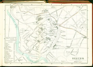
EXETER (Ee). Signature: J Bartholomew Edinr. Scale (Ee). References to Tramway Routes. No shading and no graticule. Illustrated.


1. 1884 
Thorough Guide ... North Devon And North Cornwall Second Edition, Revised
London. Dulau & Co. 1884.

Thorough Guide Series: No. VII ... South Devon And South Cornwall.
London. Dulau & Co. 1884.

Thorough Guide ... North Devon And North Cornwall Third Edition, Revised
London. Dulau & Co. 1885, 1885 (1886).

Thorough Guide ... North Devon And North Cornwall Fourth Edition, Revised
London. Dulau & Co. 1888.

Thorough Guide Series: South Devon and South Cornwall Second Edition, Revised
London. Dulau & Co. 1885, 1885 (1886), 1885 (1887).

2. 1890 List of Railway Stations and Hotels outside left border. Some light purple shading and brown tram tracks. Graticule A-H horizontal and a-f vertical. Signature: John Bartholomew & Co. Edinr. Copyright: (AeOS). 
Inclusion of new names, eg Barnfield Road, Barnfield Crescent. Some building names changed, eg Bude Haven Hotel (now Bude Hotel), Cavalry Barracks is Higher Barracks and Free Ch. (now Wesleyan Chapel) etc. Key has City Walls. Previous theatre is now Drill Hall and a new Theatre on Longbrook Street.

Thorough Guide ... South Devon And South Cornwall Third Edition, Revised.
London. Dulau & Co. 1889 (1890).

3. 1890 No shading or colour except to river (blue).

Thorough Guide ... North Devon And North Cornwall Fifth Edition, Revised.
London. Dulau & Co. 1890 (1891).

Thorough Guide ... North Devon And North Cornwall Sixth Edition, Revised.
London. Dulau & Co. 1892, 1892 (1893), 1892 (1894).

4. 1892 List moved to map area (Ae). Signature:
J Bartholomew Edinr. Illustrated.


Thorough Guide ... South Devon And South Cornwall Fourth Edition, Revised.
London. Dulau & Co. 1892 (1891), 1892 (1893).

5. 1896 List again outside left border in new script with hotels in list in brown colour.

Thorough Guide ... North Devon And North Cornwall Seventh Edition, Revised.
London. Dulau & Co. 1896, 1897, 1897 (1898), 1899, 1899 (1900), 1899 (1901).

6. 1901 List again in map area but in new script. Tram tracks now brown. Hotels not coloured.

Thorough Guide ... South Devon And South Cornwall Fifth Edition, Revised.
 London. Dulau & Co. 1895 (1900).

 Dulau - Thorough Guide Series

Dulau (North) 12 

Size: 115 x 245 mm. Scale 1 inch to a Mile (2 = 50 mm) Miles. 

SECTION MAP No. 5 with title ENVIRONS OF HARTLAND AND CLOVELLY (Aa) with map number on EP map: MAP V (p.65). Signature: John Bartholomew & Co. Edinr. Scale (Aa). Copyright: (AeOS).

Description: Area from Longpeak and Lymebridge south of Hartland Quay to Hoops Inn and Wayton in east. No hachuring. Illustrated. 

1. 1890 Thorough Guide ... North Devon And North Cornwall Fifth Edition, Revised.
London. Dulau & Co. 1890 (1891).

Thorough Guide ... North Devon And North Cornwall Sixth Edition, Revised.
London. Dulau & Co. 1892, 1892 (1893), 1892 (1894).

2. 1896 SECTION MAP No. 6 (map number on EP map: MAP 6 (p.65)). Slightly shorter to east (115 x 230 mm) with Bucks Mill and Walland in east.

Thorough Guide ... North Devon And North Cornwall Seventh Edition, Revised.
London. Dulau & Co. 1896, 1897, 1897 (1898), 1899, 1899 (1900), 1899 (1901).


Dulau - Thorough Guide Series

Dulau (North) 11 

Size: 140 x 355 mm.  Scale 1 inch to a Mile (2 = 50 mm) Miles. 

SECTION MAP No. 3 with title ENVIRONS OF LYNTON (Ea) with map number on EP map: MAP III (p.50). Signature: John Bartholomew & Co. Edinr (EeOS). Scale (Aa). Copyright: (AeOS).

Description: Area from Holdstone Down to Culbone in east. Illustrated. 


1. 1890    Thorough Guide ... North Devon And North Cornwall Fifth Edition, Revised.

               London. Dulau & Co. 1890 (1891).


Dulau - Thorough Guide Series

Dulau (North) 10 

Size: 90 x 145 mm. English Miles (8 = 50 mm). 

SECTION MAP No. 1A with with map number on EP map: MAP IA (p.21). Signature: John Bartholomew & Co. Edinr. Scale (Aa). Copyright: (AeOS).

Description: Area from Barnstaple bar in east to Lynton. Illustrated. 

1. 1890          Thorough Guide ... North Devon And North Cornwall Fifth Edition, Revised.
London. Dulau & Co. 1890 (1891).

Dulau - Thorough Guide Series

Dulau (North) 9 

Size: 140 x 275 mm.  Scale 1 inch to a Mile (2 = 50 mm) Miles. 

SECTION MAP No. 4 with title ENVIRONS OF ILFRACOMBE (Aa) with map number on EP map: MAP IV (p.60). Signature: John Bartholomew & Co. Edinr. Scale (Aa). Copyright: (AeOS).

Description: Area from Blackstone Point in east to Morte Point and south to West Down and Bittadon. No hachuring. Illustrated. 

1. 1890 Thorough Guide ... North Devon And North Cornwall Fifth Edition, Revised.
London. Dulau & Co. 1890 (1891).

Thorough Guide ... North Devon And North Cornwall Sixth Edition, Revised.
London. Dulau & Co. 1892, 1892 (1893), 1892 (1894).

2. 1896 SECTION MAP No. 5 (map number on EP map: MAP V (p.60)).

Thorough Guide ... North Devon And North Cornwall Seventh Edition, Revised.
London. Dulau & Co. 1896, 1897, 1897 (1898), 1899, 1899 (1900), 1899 (1901).

 Edward Croydon 4 Shortly after the arrival of the South Devon Railway into Teignmouth, Edwad Croydon published a detailled plan of the town...