WARD & LOCK Ward & Lock 9 - Plan of Ilfracombe Size:140 x 230 mm. Scale of Yards (200 = 55 mm). PLAN OF ILFRACOMBE (Aa). Imprint: WARD, LOCK & Co LTD, WARWICK HOUSE, SALISBURY Sq LONDON (CeOS). Signature: G. Philip & Son, London & Liverpool. (EeOS). Covers the area from Torrs Park and White Pebble Bay (west) to Rapparee Cove (east) and including the station (Be). 1. 1897 A New Pictorial and Descriptive Guide To Bideford, Clovelly, Hartland and North West Devon London, New York and Melbourne. Ward, Lock & Co. Ltd. (1897). BL, TM. RETURN to Catalogue of Maps RETURN to List of Ward & Lock Maps
Posts
Showing posts with the label Ilfracombe
- Get link
- X
- Other Apps
WARD & LOCK Ward & Lock 4 - Ilfracombe This map of Ilfracombe was replaced by 1897 by a new map (see Ward & Lock 9 ). Size:140 x 230 mm. Scale of Yards (500 = 55 mm). ILFRACOMBE (Ce). Signature: G. Philip & Son, Fleet Street. (EeOS). 1. 1887 Ward And Lock's Pictorial and Descriptive Guide To North Devon London. Ward, Lock & Co. 1887. DevA [1] . Ward And Lock's Pictorial and Historical Guide To North Devon London. Ward, Lock & Co. (1887). KB. A New Pictorial and Descriptive Guide To Ilfracombe, Barnstaple and North-West Devon London, New York & Melbourne. Ward, Lock & Co., Ltd. (1897). BL. RETURN to Catalogue of Maps RETURN to List of Ward & Lock Maps
- Get link
- X
- Other Apps
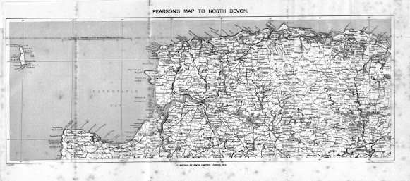
ARTHUR PEARSON Charles Arthur Pearson produced a series of Gossipy Guides at the end of the 19 th century. Like the Ward and Lock series of guides they were full of photographic material in a handy pocket size. Two guides were produced covering Devon: Guide to Ilfracombe and District (cover title; number 4 in the series); and Guide to South Devon (number 8 in the series). Both volumes were published 1900-1901. Pearson took maps from different sources to include in his two Devon guides. The map of South Devon included in that guide was a transfer of Bartholomew’s map (see Bartholomew Imperial 8): however, the map of North Devon is taken from the plates prepared by George Ravenstein for George Philip in 1899. The scale reveals that this is a Philip’s map: the scale of 1:200,000 was first used for Philip’s 10-sheet Road Map of England & Wales . Another local trader also used transfers of this map to produce a folding map: Varnan, Mitchel & Co. Ltd of the Week
- Get link
- X
- Other Apps
John Murray - Handbook for Travellers The following Murray maps can be found in the following editions: 1. 1895 A Handbook for Travellers in Devon ... Eleventh Edition revised London. John Murray. 1895, 1895 (1896). KB; TM. A Handbook for Travellers in Devon ... Eleventh Edition revised London. Edward Stanford. 1895 (1901) [1] . KB. Murray 11 - Torquay 2 Size : 160 x 260 mm. Scale: (4 = 37 mm) FURLONGS OR ½ MILE . TORQUAY 1895 . (Ea). Imprint: London. John Murray. (CeOS). Description: Area from Flat Rock to Chelston Cross; Rock End to St Mary Church. Murray 12 - Ilfracombe Size : 155 x 255 mm. Scale: (4 = 80 mm) FURLONGS OR ½ MILE . ILFRACOMBE 1895 . (Aa). Imprint: London. John Murray. (CeOS). Signature: STANFORD'S GEOGL. ESTABMT LONDON (EeOS). Scale (Aa). Description: Area from Brandy Cove to Rapparee Bathing Cove; South to Langleigh Farm. RETURN to Catalogue of Maps NOTES: [1] Title
- Get link
- X
- Other Apps
John Murray - Handbook for Travellers The following Murray maps can be found in the following editions: 1. 1895 A Handbook for Travellers in Devon ... Eleventh Edition revised London. John Murray. 1895, 1895 (1896). KB ; TM . A Handbook for Travellers in Devon ... Eleventh Edition revised London. Edward Stanford. 1895 (1901) [1] . KB . Murray 9 - Lynton, Ilfracombe and Barnstaple Size : 160 x 300 mm. Scale: (4 = 50 mm) Miles . LYNTON, ILFRACOMBE, AND BARNSTAPLE . (CaOS). Imprint: London. John Murray, Albemarle Street. (CeOS). Signature: J Bartholomew Edinr (EeOS). Scale: (Aa). Copyright : (AeOS). Description: Area from Foreland Point (in border) to Baggy Point and south to Crow Rock. Layer colouring with height table (Aa-Ab): section is taken from Bartholomew's 1895 map of South Devon. Murray 10 - Torrington, Bideford and Clovelly Size: 160 x 300 mm. Scale: (4 = 50 mm) Miles . TORRINGTON,
- Get link
- X
- Other Apps
Dulau - Thorough Guide Series Dulau (North) 9 Size: 140 x 275 mm. Scale 1 inch to a Mile (2 = 50 mm) Miles . SECTION MAP No. 4 with title ENVIRONS OF ILFRACOMBE (Aa) with map number on EP map: MAP IV (p.60). Signature : John Bartholomew & Co. Edinr. Scale (Aa). Copyright : (AeOS). Description: Area from Blackstone Point in east to Morte Point and south to West Down and Bittadon. No hachuring. Illustrated. 1. 1890 Thorough Guide ... North Devon And North Cornwall Fifth Edition, Revised. London. Dulau & Co. 1890 (1891). Thorough Guide ... North Devon And North Cornwall Sixth Edition, Revised. London. Dulau & Co. 1892, 1892 (1893), 1892 (1894). 2. 1896 SECTION MAP No. 5 (map number on EP map: MAP V (p.60)). Thorough Guide ... North Devon And North Cornwall Seventh Edition, Revised. London. Dulau & Co. 1896, 18
- Get link
- X
- Other Apps
Dulau - Thorough Guide Series Dulau (North) 7 Size: 90 x 145 mm. 3/4 English Mile (3/4 = 30 mm). ILFRACOMBE (Ce). Signature : J. Bartholomew. Edinr. Description: Area from The Tor in north west to Rapparee Cove in southeast. No hachuring. Scale (Ce). Station is identified as London & South Western Railway Station . 1. 1882 Thorough Guide Series: ... North Devon And North Cornwall London. Dulau & Co. 1882, 1883. Thorough Guide ... North Devon And North Cornwall Second Edition, Revised London. Dulau & Co. 1884. Thorough Guide ... North Devon And North Cornwall Third Edition, Revised London. Dulau & Co. 1885, 1885 (1886). Thorough Guide ... North Devon And North Cornwall Fourth Edition, Revised London. Dulau & Co. 1888. 2. 1890 Signature: John Bartholomew & Co. Edinr. (EaOS). Copyright (AeOS). Station is now identified as London & Sou
- Get link
- X
- Other Apps
The Guide Book Scroll down for chapters on: Devon Guide Books Centres of Production - London Centres of Production - Edinburgh Centres of Production - Plymouth Centres of Production - The “Library” at Ilfracombe Centres of Production - Exeter Centres of Production - Teignmouth and Torquay Introduction One of the interesting developments of the Victorian age was that of the guide book. From earliest times some people had travelled, and travelled widely. There are numerous accounts of early travellers who journeyed long distances. Whether it was Julius Caesar in search of conquest, Arab treasure hunters seeking archaeological sites, merchant venturers such as Marco Polo in search of new trade routes or trading partners or people like John Bill , commissioned by Sir Thomas Bodley to travel to the Frankfurt Book Fair in order to buy the latest bestseller anno 1600, few either had maps or left maps behind or had the use of a travel guide in the modern sense. Perhaps the earliest