Posts

Showing posts with the label Improved Map
Image
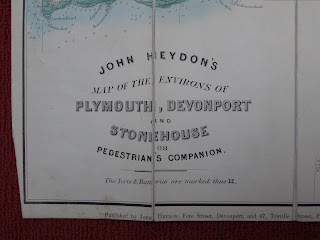
John Cary -   John Heydon   The first local publisher to issue a map derived from Cary's Improved Map was John Heydon   in his Map of the Environs of Plymouth, Devonport and Stonehouse or Pedestrian’s Companion . The map shows almost 90% of sheet 2 of Cary’s map. This version would seem to pre-date both the Seeley map of Torquay and the A H Swiss   derivatives by a number of years from evidence of the railway network but the area covered is, in fact, very similar to that included in the Swiss map, A H Swiss' No. I Hunting Map. The Plymouth District. John Heydon published two further maps of Plymouth for tourists ( c.f. ) and one of the first county maps of Devonshire based on the Improved Map plates was also published by Heydon (see B&B 150 ). The county map [1] first appeared circa 1872 and also carried a note about forts and batteries (see below).     Size: 460 x 575 mm.                      ...
Image
  John Cary -   Arthur Westley Arthur Westley  began business in the late 1870s taking over from Edward Cockrem (see Cockrem 5). He seems to have commissioned only one map (but it may also have been taken over from Cockrem) but was offering a range of different maps of Torquay and the neighbourhood between 1880 and 1885. One of the maps he offered was taken from  the Cary plates of the Improved Map . His business was, in turn, taken over by Leonard Seeley.   L Seeley   was a Torquay bookseller and library proprietor. In circa 1885 he was issuing a map based on work by Cary’s Improved map only differing from Westley’s in small details and a slight “shift to the east”. Also at about this time he was selling an updated version of a map produced by W Elliott   which was now some 50 years old ( c.f. ). Exactly which map replaced which, or whether Seeley was selling both together cannot be clarified. However, the selection of other items being sold (on bac...
Image
  John Cary -  The IMPROVED MAP of ENGLAND and WALES Cary's Improved Map of England and Wales with a considerable part of Scotland consisted of a total of 65 maps and was first published in parts by John Cary, in London between 1820 and 1830. Cary sold the sheets as a boxed set of folding maps and as an atlas in 1832. After Cruchley obtained the maps he continued to sell each sheet separately in covers as Cruchley's Reduced Ordnance Map of England and Wales , and in a variety of different covers, each section being approximately 500 by 630 mm. Cruchley even went to the lengths of cutting six maps to size to compile a map of Devon from the five sheets containing Devon plus the Somerset sheet, No. 17 (see B&B 138A ). Similarly, George Richmond took parts of these sheets to produce his Exeter map in c.1876. The sheets were used again by Seeley c.1890, by A H Swiss for his fox-hunting maps in c.1890 and parts appeared in the Homeland Handbooks at the end of the century. The li...