Posts

Showing posts with the label A & C Black
Image
 WALKER & BOUTALL - Black A & C Black’s guides to Devonshire were already over 30 years old when new maps were ordered from the company Walker & Boutall to supplement the maps drawn and engraved by John Bartholomew (see A & C Black ). In addition to the general area maps listed here, there was a very small sketch plan of Westward Ho! embedded in the text with a short description. All the maps listed below can be found in the following guides: 1. 1895  Black’s Guide To Devonshire ... Edited by A R Hope Moncrieff ... Fifteenth Edition London. Adam and Charles Black. 1895, 1895 (1897). KB, C; DevA. Black’s Guide To Devonshire ... Sixteenth Edition London. Adam and Charles Black. 1898, 1898 (1901). C, MW; KB. Maps 1a and 1h only can also be found in: Black's Guide To Torquay And The South Hams ..., Salcombe, Etc. London. Adam and Charles Black. 1901. KB. Walker & Boutall 1a Size: 130 x 85 mm. ...
Image
A & C  Black 7 - Railways   Black's Picturesque Guide   first appeared in 1843 and, like all other A & C Black   guide books, was republished regularly. The first edition contained a map of England and Wales; by 1845 there were 10 maps, by 1848 there were 14 and by 1855 a total of 25 maps were being issued. The first editions were not numbered, but by 1855 adverts within the volume were advertising the 3 rd edition. The editions from 1878 had 54 maps when the title was also changed. The map below has the signatures of Schenck and M’Farlane   but these were soon removed and the signature of John Bartholomew is found on most maps used by the Blacks. Friedrich Schenck   was born in Offenbach, Germany, in 1811 (full name Emil Ernst Friedrich Theodor Schenck) and died in Edinburgh in 1885. He trained as lithographer and artist in Munich and Paris. In 1840 he moved to Edinburgh at the invitation of Samuel Leith   and proceeded to give talks on litho...
Image
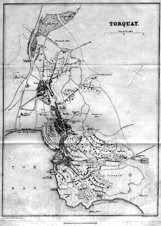
A & C  Black 2 - Torquay Whether John Bartholomew had friends or relatives in Torquay is not known, but the constant updating of his map of Torquay certainly suggests he had. While most of Blacks maps were sparingly altered, Torquay was updated in some small way for almost every edition from 1862 to 1900. Size: 195 x 145 mm.      Scale of ½ a Mile (1/2 = 35 mm).     TORQUAY. (Ea). Signatures: Printed by W H M c Farlane, Edin r . (AeOS); and J. Bartholomew Edin r (EeOS).   Imprint: Published by A & C Black, Edinburgh (CeOS). Torquay Branch Railway with one station (at Torre). Illustrated above.   1. 1862       Black’s Guide To The South-Western Counties Of England.   Devonshire.                          Edinburgh. Adam and Charles Black. 1862.      KB.          ...