Posts

Showing posts with the label Torquay Guide
Image
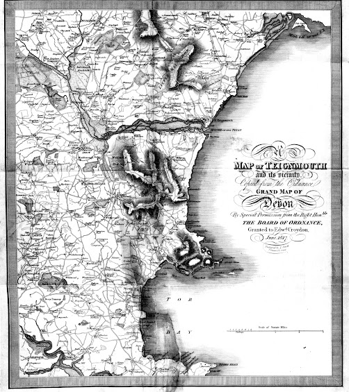
 Edward Croydon, Senior and Junior For more information on Croydon, see my article on Torquay booksellers. Click here. Edward Croydon and his two sons, Henry George (Teignmouth) and Edward (Torquay) published three maps. Croydon 1 - see below. Croydon 2 - The Teignmouth Guide (later also  The Torquay Guide ) - click here. Croydon 3 - Torquay and its Neighbourhood - click here.  In 1817 E dward Croydon  printed and sold a most attractive guide books of Devon. The Guide to the Watering Places, on the Coast, Between the Exe and the Dart ; … consisted of sixteen (and occasionally found with 17) coloured aquatints (of which four are folding) by D Havell , T Shury , and J C Stadler , after drawings by W B Noble  (JVSC S.64). This was originally issued in three parts published in 1817 and 1818 with a map engraved by J Smith  of London when bound complete [1] . Although all title pages to the first printing are dated 1817, at least seven of the views included a...
Image
  Arthur Westley 1   NEW - Please note Westley 1 and 2 are now Cockrem 6 and 7. Arthur Westley took over much of Edward Cockrem´s stock and rights to publish when Cockrem died in 1872. He was certainly keen to make the most of the tourist trade and general interest as his publishing output shows. One of the maps below still has its original covers and proves that Westley was offering all of the following for sale at the same time: Westley’s Tourist Guide to Torquay & Neighbourhood (certainly later editions of Cockrem’s guide); Westley’s Large Scale Plan of the Town of Torquay at 12 miles to the inch; Westley’s Map of 25 Miles Round Torquay ; as well as books of views and also Westley’s Sixpenny Guide to Torquay & Neighbourhood (no known copy survives). His Westley’s Plan of the Town of Torquay at 8 inches to the mile (price 1/-, see below) as well as the same map but with a special index of over 1000 Villas, Terraces, &c. (price 1/6) were clearly later example...