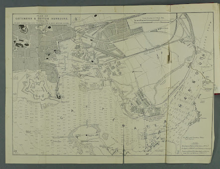
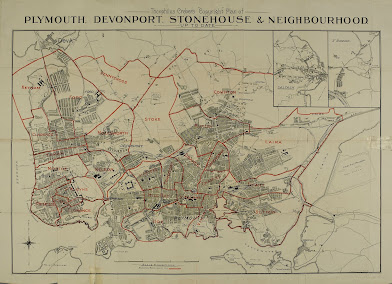
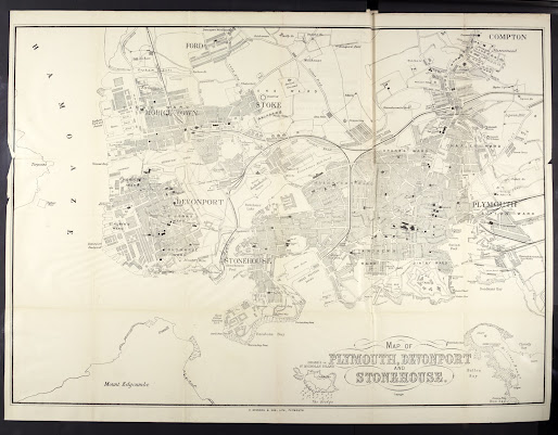
Brendon & Son 2 Brendon & Son, while being well-known for their publishing of the Plymouth Transactions (given the relationship with the President) also published two maps which appeared in Eyre Brothers’ Post Office Plymouth and Devonport District Directory . Their first map was originally published c. 1876 and then updated when it appeared in the Third Edition of the directory. The directory changed hands frequently and included other maps. The work became Eyre´s Post Office Plymouth and Devnport District Directory in 1890 but in the 4 th edition of 1888 another Brendon map appeared. Other issues of the directory, which was published by Eyre Brothers themslves from 1880 to 1888 and by others until 1904, included either a map by Maddock , lithographed by John Smith or by Creber . The map below is very much a sailor´s or mariner´s chart. The soundings throughout the harbour area are set out in a systematic matrix and there is a note concerning high and low...
Posts
Showing posts from June, 2021
- Get link
- X
- Other Apps
Theophilus Creber In 2016 the British Library held an exhibition “There will be fun” centred on the entertainment industry of the Victorian era. Laurence Worms in his blog The Bookhunter on Safari mentions Theophilus Creber in connection with a number of posters and a newspaer clöipping. The following is his portrayal of Creber in connection with the exhibits: This Sanger poster [illustrated below] is by the prosperous Theophilus Creber (1845-1902) of Plymouth, who described himself as a “show printer”. Brought up in Devonport Workhouse (not as an inmate, his father was the teacher), he was a man in love with his work to the extent that he took his own lease on the old Olympia Theatre in Plymouth and re-opened it in 1887 as a Theatre of Varieties, promising “first class entertainments … free from anything objectionable in the slightest degree”. By 1898 he had taken over the Theatre Royal at Eastbourne, spending a fortune on refurbishing it. [1] He goes on to explain the...
- Get link
- X
- Other Apps
John Smith The Eyre Brothers were publishers with premises at 10, later 26 & 27, Paternoster Square, Paternoster Row, London. Their output seems to have been limited (only a handful of entries under COPAC) but they did produce some works relevant to Devon. The George Philips map of Devon (see B&B 149 ) was used in a number of works designed for both tourist and local resident published by Eyre Brothers of London: The Watering Places of the South of England (1877); Eyre’s Guide to the Seaside and Visiting Resorts of Devon & Cornwall (1878); and Eyre’s Hotels of the United Kingdom (1879, 1881). In 1880 they produced a directory for the Plymouth area and Eyre Brothers’ Post Office Plymouth District Directory , embracing Plymouth, Devonport, Stonehouse, and the District Five Miles Round (First Edition, 1880-81) [1] included the Philip map of the county. The Post Office Directory was reissued at two year intervals (with slight change...
- Get link
- X
- Other Apps
William Henry Maddock William Henry Maddock was a printer, engraver and lithographer in Plymouth and appears to have been active from circa 1848 to the mid-1880s. His only known publishing venture would seem to be the map below, dated 1848, and there may have been a reprint in 1853 (see Brockett). Although there is no address on the map below, Maddock was at 32 Frankfort Street 1852-56 but in 1890 the address was 86 Treville Street. He seems to have been a specialist lithographer and as well as printing the three maps listed below also printed two for John Heydon of the same area; he also lithographed a map of Exeter for Jewitt - a Plan Of The City Of Exeter appeared in a guide book to the Agricultural Exhibition in Exeter in 1850 (published by H. J. Wallis, Exeter, and R. Lidstone, Plymouth) and which bears the signature of Maddock & Balderston Lithographers, 17, Bedford St Plymouth ; and a Map Of Salcombe, Kingsbridge, And Surroundings for James Fairweather ...
- Get link
- X
- Other Apps
ANON 2 - FARLEY’S HOTEL Farley´s Hotel was located at 46-47 Union Street in Plymouth and got its name from the proprietor from 1853 to 1877, Mrs Farley, although the premises had been a hotel / bar before she took it over. CH Walter took over the premises in 1877 and as part of the advertising for the hotel a sketch map was drawn up to show potential tourists the location. The map has been seen in four separate publications, but no doubt it appeared more frequently. Walter remained the proprietor of the hotel until 1890. [1] The adverts always included a picture of the hotel, first from the corner aspect and later from the front. The first appearance of the map is in Percy’s Calendar & Register for 1876 . This small volume was a mixture of guide book and gazetteer but with a large advertising section at the back. The Three Towns Directory published only a year later also included the map. It is also found in a guide to Berry-Pomeroy dated to approximately the same time but the adv...
- Get link
- X
- Other Apps
Brendon & Son Richard Nicholls Worth was a professional writer. He was born in 1837 at Devonport and except for a brief period in Newcastle (as editor of the Northern Daily Express ) he spent all his years in or near Plymouth. As a young man he was apprenticed to R C Smith of the Devonport and Plymouth Telegraph and became chief reporter when that paper merged with the Western Morning News . After a year spent in the north he returned to the Western Morning News from 1867 to 1876. [1] During this period he researched his History of Devonport and his History of Plymouth which were published in 1870 and 1871 respectively. The timing of the second book was fortuitous as Llewellynn Jewitt ( c.f .) also published a history of Plymouth a year later. Worth’s History contains four small maps but all are copies of earlier maps outside of the scope of this present work. [2] Maybe it was the success of th...