Brendon & Son
Richard Nicholls Worth was a professional writer. He was born in 1837 at Devonport and except for a brief period in Newcastle (as editor of the Northern Daily Express) he spent all his years in or near Plymouth. As a young man he was apprenticed to R C Smith of the Devonport and Plymouth Telegraph and became chief reporter when that paper merged with the Western Morning News. After a year spent in the north he returned to the Western Morning News from 1867 to 1876.[1] During this period he researched his History of Devonport and his History of Plymouth which were published in 1870 and 1871 respectively. The timing of the second book was fortuitous as Llewellynn Jewitt (c.f.) also published a history of Plymouth a year later. Worth’s History contains four small maps but all are copies of earlier maps outside of the scope of this present work.[2]
Maybe it was the success of these books, and the latter in particular,
but Worth resigned his post at the newspaper in 1876 and joined the local
printing and publishing business of Brendon & Son. The map described below
was included in his Guide to the Three Towns and
Neighbourhood which was
published soon after with a reprint a few years later with the map below.
Besides updating and reissuing his History
of Plymouth, Worth was a contributor to the Tourist’s Guide series published by Edward Stanford (see B&B154: South Devon and North Devon
appeared circa 1878 and 1879) with information on other counties and areas
beyond Devon (e.g. Wye, Kent and Surrey). He was a regular contributor to the
Transactions of the Devonshire Association, and also became its President. He
was also active in, and became President of, the Plymouth Institution. He died
in July 1896 at Shaugh Prior.
In 1885 the same map was included in Eyre Brothers’ Post Office Plymouth and Devonport District Directory. However, for the 4th edition published in 1888 the Brendons commissioned a new map showing Cattewater and Sutton Harbour.
Other issues of the directory, which was published by
Eyre Brothers from 1880 to c. 1904,
included either a map by Maddock (see Maddock 3) or lithographed by John
Smith (see Smith, J).
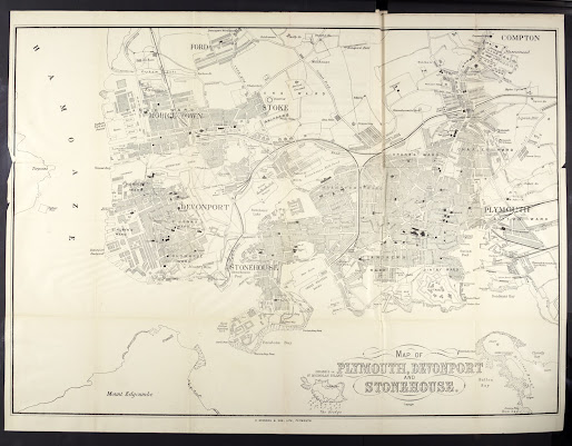
MAP OF PLYMOUTH, DEVONPORT
AND STONEHOUSE, (De) with Copyright
below (title begins left of a line through The Hoe and T of Devonport is
alongside the pier on Mount Batten. Imprint: W. BRENDON & SON, LITH,
PLYMOUTH. (CeOS, under Great Western Docks).
From Keyham Lake (Aa) to Mount Edgcumbe (Ae) and east to Compton (Ea) and
Batten Bay (Ee).
1. 1876 Guide to the Three Towns and Neighbourhood by R N Worth
2. 1878 Map
now 510 x 690 mm. Drake’s Island or St. Nicholas’ Island has been added and the
title moved to accommodate it: title now is below The Hoe and the pier on Mount
Batten deleted. Imprint is now below Firestone Bay. Rum Bay at Mount Batten now
also included.
Guide
to the Three Towns and Neighbourhood by R N Worth
3. 1885 Extended
west (to include Torpoint): size 490 x 690 mm. As above but lacks the new
developments in Sutton Ward. Illustrated by kind permission of NLS.
Eyre
Brothers’ Post Office Plymouth and Devonport District Directory, ...3rd Edition
London. Eyre Brothers. 1885-86. NLS.
RETURN to Main Catalogue
NOTES:
[1]
Summarised from Brian Moseley’s text at www.plymouthdata.info - an excellent
site for Plymouth history generally.
[2] They were: a map of Plymouth Haven - a copy of Daniel Lysons’ own extract
of a much larger manuscript map prepared for Henry VIII which had appeared in Magna Britannia (B&B 89); a copy of a manuscript map prepared for Queen
Elizabeth I by Spry; the True Mapp was taken from a map executed
by Wenceslas Hollar for inclusion in A
True Narration of the most Observable Passages of 1644; and finally, The Plan of Plymouth was copied from the
large inset map of Plymouth contained in Benjamin Donn’s 12 sheet map of Devon
executed in 1765 (B&B 44). All
four maps have been redrawn to a much reduced size of approx. 100 x 160 mm
retaining most of the information but without the same detail.
[3]
Last date in text.
[4]
Volume has adverts for the Provident Life insurance which are dated 1878.


No comments:
Post a Comment