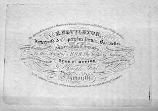
Edward Nettleton
Edward Nettleton was a bookseller, printer and publisher in Whimple Street, Plymouth. Besides publishing an early edition of Henry Woolcombe´s famous guide, The Tourist's Companion to the most interesting objects … of Plymouth,Devonport and Stonehouse .... in 1828, in 1836 he printed and published a guide to Plymouth etc. written especially for him by George Wightwick, an architect. Nettleton's Guide to Plymouth, Stonehouse, Devonport and to the Neighbouring Country contained three maps as well as other engravings and plans. Two of the three maps were very close copies of those that had already appeared in previous works, The Tourist's Companion; Being a Guide to Devonport, Stoke, Morice-Town Stonehouse, and Plymouth, by John Sandford; and from A View Of Plymouth-Dock, Plymouth and the adjacent country published by A Granville & Son in 1812. Nettleton flourished certainly between 1801 (Zion’s Pilgrim) and 1847 (Trout Flies of Devon and Cornwall) and even produced a directory of Plymouth in 1822. In Wightwick´s guide he is offering a choice and very extensive collection of new and old books as well as stationery and used the title Printer to His Maesty and to HRH the Duke of Sussex.
In addition he ran a newspaper (see top line of his business card below) and, according to Brian Moseley, the Plymouth, Devonport and Stonehouse Herald originally started in either 1821 or 1822 as the Devonshire Freeholder and General Advertiser, was briefly renamed The Plymouth Herald and Devonshire Free-holder or West of England General Advertiser in 1830. It was owned and run by Mr William Pridham, the editor; Mr Edward Nettleton, the printer; and two silent partners, Mr William Hole Evans and Mr Richard Hicks. Although printed every Friday it was published every Saturday from an office at 3 Looe Street, Plymouth. Apparently, the Herald carried no leading article, expressed no political opinions, and had only one reporter. The paper finally ceased trading circa 1868, and was incorporated into the Western Counties Herald. The plant and printing machines were sold for £250.[1]
New York Digital Library has an interesting poster for
T P Cooke´s show printed by Edward Nettleton in 1833.[2]
On August 19th Mr Cooke was to present his “Romantic Drama” or Presumption:
or the Fate of Frankenstein with air, fire and music special effects at the
Theatre Royal after 80 nights mesmerising Parisian audiences.
Edward Nettleton was born c.1794 and died in
1859. He was buried at St Andrew´s in Plymouth together with his daughter,
Matilda (Libby) who died in 1847 aged just 24.[3]
The two maps (but not the General Plan) described
below were executed by W G Cooper whose name occurs on a few other maps during this
time. Maxted has him as William Gilborne Cooper, engraver
and copperplate printer, lithographer (1840), see the business card above. He
had premises at 86, James Street, Devonport 1830; and 43 / 44, Union Street,
Stonehouse 1840-1856.[4]
The small guide (95 x 150 mm) packed 190 pages and was illustrated with simple drawings and interesting enravings.
Nettleton / Cooper 1
Size: 145 x 140 mm. (1 = 23 mm) Mile.
The outline has been crudely copied from other maps (c.f. Cooke 7) but it lacks substantial detail.
Description: Rame Head and Mew Stone (Ae, Ee) and the course of the river as far as Tor Point (Ba). Compass point (De).
Nettleton / Cooper 2
Size: 175 x 210 mm. No scale.
GENERAL OUTLINE of the
ENVIRONS of PLYMOUTH, and DEVONPORT (under
bottom border). No imprint but a
signature: W G Cooper. Sc. (Ae).
Copied from Neele's map (c.f. Neele 1)
but lacking most of the detail, only major roads being shown. Plain two line
border. Compass (Be).
Description: The coast is shown from W Looe to Kingsbridge (Ee); inland area to Launceston and Moreton.
Nettleton
Size: 160 x 300 mm. No scale.
GENERAL PLAN shewing the
Streets and Thoroughfares of PLYMOUTH, STONEHOUSE AND DEVONPORT (Ee). No imprint but a signature
below title: Nettleton, Lith. Plymouth.
(Ee). There is no border, compass or scale.
Description: Sketch plan showing the three areas from Torpoint in the west to Laira Bridge in the east. Areas are shaded (explained in key) and several buildings are numbered (1 to 20; explained in a table on page 2 of the Guide).
[1] Brian Moseley: at https://www.oldplymouth.uk/Plymouth%20Devonport%20and%20Stonehouse%20Herald.htm.
[2] https://digitalcollections.nypl.org/items/09ee6000-0841-0135-724e-0e73ea9814f5.
[3] Find a grave website: https://de.findagrave.com/memorial/162955919/edward-nettleton.[4] Maxted: https://bookhistory.blogspot.com/2014/07/devon-book-trades-devonport.html. Maxted notes 43, the business card has 44 Union Street. See also Kit Batten´s entries for William Wood in this blog.


No comments:
Post a Comment