WILLIAM STEWART
For Stewart´s map 1 executed by Charles King click here.
For Stewart´s map 2 executed by Halfyard see below.
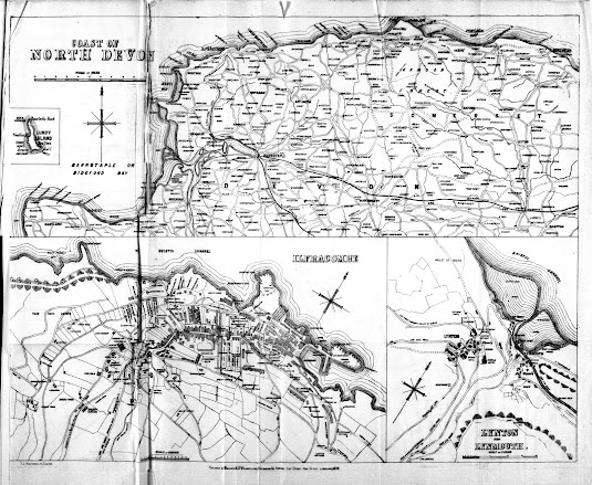
William Stewart had had a map produced, originally lithographed by Charles King of Exeter, for his own reprints of The North Devon Handbook (see Banfield and especially Stewart 1) which appeared in a number of guides between 1872 and 1878. However, shortly before, or immediately after, his business was taken over by Milligan a new plate was engraved. This second map was lithographed by the company of F J Halfyard, of Exeter. Copies of the Fourth Edition of the North Devon Handbook (under Stewart’s imprint) have been seen with either the earlier or the later map. Either Stewart needed new map sheets but did not possess the original plates (or they had become damaged or worn); or Milligan acquired ready-printed copies of the North Devon Handbook which lacked the map and had to have a new map printed before selling the surplus Stewart stock he had.
The new map (by Halfyard) is difficult to differentiate from the first map by King without a direct comparison: however, Halfyard does not name The Tors (on the Ifracombe map); nor does he note the Walk from the Valley of the Rocks (on the Lynton-Lynmouth plan). In the plan of Lynton there appears to be a chain of hills in the lower right corner: in King’s map the hills blend together and are difficult to count; in Halfyard’s map there are 16 definite mounds (although they look more like tussocks!).
Milligan took over the Library at Ilfracombe from W Stewart 1878-79 and immediately began selling the same stock of guide books as his predecessor. This takeover must have occurred shortly after Stewart had printed off a stock of the fourth edition of his Handbook. Milligan & Co.s` Arrival List, Gazette & Advertiser appeared from July 1879 to September 1882 and this may well be roughly the period he ran the Library.
A second map which appeared in guides first printed and published by Milligan was a transfer taken from Bartholomew’s Imperial Map plates. This is a map of North Devon covering a slightly smaller area than that published by W H Smith in the 1880s and 1890s (see B&B 150 states 2, 6 and 10; see Bartholomew for Milligan).
Size: 305 x 385 mm (total). SCALE OF MILES (10 = 75 mm).
Three maps on one sheet: COAST OF NORTH DEVON (scale as above). There are town maps of ILFRACOMBE (155 x 260 mm; SCALE OF CHAINS 5+10 = 37 mm) and LYNTON AND LYNMOUTH (155 x 125 mm; SCALE OF CHAINS 5+20 = 50 mm) below. Imprint: PUBLISHED BY W STEWART, BOOKSELLER, STATIONER & ARRIVAL LIST OFFICE, HIGH STREET, ILFRACOMBE, JUNE 1878. (CeOS). Signature: F J HALFYARD, LITHO, EXETER. (AeOS).
1. 1878 The map shows the coast from Harland to Minehead. The railway is shown to Ilfracombe.
Stewart's Shilling Guide Book to North Devon: New Edition
Ilfracombe. W Stewart. (1878). BL[1], [P].
2. 1878 Imprint: PUBLISHED BY MILLIGAN & CO. BOOKSELLERS & ARRIVAL LIST OFFICE, HIGH STREET, ILFRACOMBE, 1878. (CeOS).
The North Devon Handbook: Fourth Edition
London: Simpkin, Marshall, And Co. Ilfracombe: W Stewart. (1877)[2]. DevA.
3. 1879 Date in imprint changed to 1879. Illustrated.
Milligan & Co.'s (Late Stewart's) Shilling Guide Book to North Devon. New Edition
Ilfracombe. Milligan & Co. (1879). KB, [Bid].
[1] BL copy is RB.23.a.26316 and a further copy sold by Roger Collicott: Catalogue 60:220.
[2] BL and author have copies with Stewart 1.
Ilfracombe. W Stewart. (1878). BL[1], [P].
2. 1878 Imprint: PUBLISHED BY MILLIGAN & CO. BOOKSELLERS & ARRIVAL LIST OFFICE, HIGH STREET, ILFRACOMBE, 1878. (CeOS).
The North Devon Handbook: Fourth Edition
London: Simpkin, Marshall, And Co. Ilfracombe: W Stewart. (1877)[2]. DevA.
3. 1879 Date in imprint changed to 1879. Illustrated.
Milligan & Co.'s (Late Stewart's) Shilling Guide Book to North Devon. New Edition
Ilfracombe. Milligan & Co. (1879). KB, [Bid].
RETURN to Catalogue of Maps
NOTES:
[1] BL copy is RB.23.a.26316 and a further copy sold by Roger Collicott: Catalogue 60:220.
[2] BL and author have copies with Stewart 1.


No comments:
Post a Comment