W H Kearley WRIGHT
W H Kearley Wright was the Borough Librarian in Plymouth when he wrote his history of Okehampton. However, he was also the editor of a series of magazines, The Western Antiquary; or Devon and Cornwall Note-Book. These were published between 1881 - 1892 with W H Luke being the printer/publisher for many of the issues; Latimer and Son from 1881 – 1886; and in London, Elliot Stock, 1896.
The magazine included numerous illustrations, plans, pedigrees, etc inc. folding. It was a wonderfully ambitous monthly publication, with contributions from leading local historians; it covered every aspect of life, historical, topographical, current in Cornwall and Devon. A few additional parts were published in 1895, forming a twelve volume set.
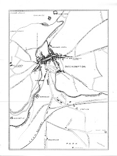
Wright's history of Okehampton appeared in 1887 with text: this was a reissue of parts published in c.1839 and printed by G P Hearder with additional notes by Rev. H G Fothergill and updated with new chapters plus a map.
Wright 1
Size: 215 x 155 mm. No Scale.
The map has no title but shows OKEHAMPTON (Cb); it is drawn from the OS map of the district from Home Farm in the north to the reservoir in the south.
1. 1887 Some Account Of The Barony And Town Of Okehampton. A New Edition.
Tiverton. William Masland. 1889. KB.
Wright 2
Picturesque South Devon appeared at the beginning of the 20th century; the last date in the text is 1900 and although the railways from Ashton to Exeter (1901) and from Exmouth to Budleigh Salterton (1903) are included on the map, they are not mentioned in the text. The map was actually the lower half of a map executed c.1894 by F S Weller for The Comprehensive Gazetteer of England and Wales, edited by J H F Brabner and published by William Mackenzie. The shire series editor was A H Millar FSA and the Devon volume was by W H K Wright.
The map shows a number of changes; new title, Bartholomew’s signature, removal of imprint, compass added, scale bar reduced, border altered and lowered to include more sea, parliamentary divisions removed and colouring altered accordingly. Salterton becomes Budleigh Salterton. Shows railways from Ashton/Doddiscombleigh to Exeter and Budleigh Salterton (1901/1903 but planned much earlier).
Size: 160 x 213 mm. English Miles (10 = 28 mm).
SOUTH DEVONSHIRE (Ed). The map has imprints: Copyright (AeOS); and John Bartholomew & Co. Edinr (EeOS). Graticuled border and compass rose (Dd) above title and scale bar. County border and coast colured pink.
1. 1900 The Shire Series: Picturesque South Devonshire. By W H K Wright
London. Valentine & Sons Ltd. (1900). DevA, KB.
RETURN to Catalogue of Maps


No comments:
Post a Comment