WILLIAM WOOD


A popular local guide first published c.1855 was The Hand-Book to South Devon and Dartmoor. The author was probably William Wood, a publisher with premises in Devonport. He published a great number of local guide books including ten editions of the Hand-Book of Devonport, the Three Towns’ Almanack, from 1860 until 1896, Rambles and Excursions (of Plymouth) and the Handbook to Cornwall (c.1880). All these works were illustrated with maps. The first two editions of the South Devon handbook included a close copy of the Ebden/Duncan county map first published in 1825 (95, see also 129A in Victorian Maps) and which had recently reappeared in Henry George Collins’ The New British Atlas.

However, when the Hand-Book was reissued as the Third Edition only a few years later this large map was replaced by one of the southern part of the county. Later copies of the almanack also contained this smaller map of South Devon, possibly amended by W G Cooper, engraver and lithographer in Union Street, Stonehouse. This third edition of the south Devon guide also included a map of Exeter and a map of Plymouth.

The First and Second Editions of Wood’s guide appeared circa 1855; the last date in the text being 12th February 1853 relating the deaths of two soldiers on Dartmoor. The Third Edition has a slightly updated text and the last date mentioned is September 1856 on the railway being built to Exmouth (which was completed in 1861). There is also reference to the Tavistock railway will shortly be opened (opened 22nd June 1859).

The Three Towns' Almanack was issued from circa 1860 to the mid-1890s. Many of these contained maps which are usually called for on the title page. Various maps were included in this publication throughout this period: see also Cooke 13, Rundell/Thomas and the maps Wood 1, 2 and 3 below. Devon Archives has various copies of the almanac from 1863 to 1896. In addition to the issues listed under the above entries, copies for 1867, 1871, 1873 to 1880 and 1895 are held. These contain no map and none is called for.

Wood 1 was used by Bazley and Company and the map appeared in an album of views: Bazley’s Views of Plymouth. This was a typical publication at the end of the century with leaves of views opening out like a leporello. Bazley and Company were booksellers, stationers, bookbinders, relief stampers and printers. They also ran a circulating library from their premises in Bedford Street, Plymouth. One of the views in the album is of their shop, presumably they had the album specially made. They also used a map by Foster (c.f.).

Palmer & Stone advertised in Billing’s Directory and Gazetteer of 1857. They had taken over from Angel & Co. (c.f.) and advertised themselves as Practical Engravers, Copper-plate and Lithographic Printers as well as providing the usual odd assortment of services, e.g. wedding orders, maps, bill heads and cards all executed on very short notice and at the lowest possible price. They operated the West of England Engraving and Printing Office at 3, Waterbeer Street and were established in 1816. Wood 4 is a close copy of Besley’s map of Exeter.

Besides the reprinting of Cooke 13 and the Rundell - Thomas maps, William Wood published at least four new maps (click to access):

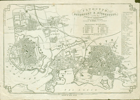
Wood 1: PLYMOUTH, STONEHOUSE & DEVONPORT with the RECENT IMPROVEMENTS From a Survey by W. W. Rundell. See below.
Wood 2Map of MOUNT EDGCUMBE PARK, also by W W Rundell Sc.
Wood 3SOUTH-DEVON
Wood 4MAP OF EXETER Corrected to the present time printed by PALMER & STONE, EXETER.


Wood 1

Size: 185 x 270 mm. (80 Chains = 92 mm) SCALE OF ONE MILE.

PLYMOUTH, STONEHOUSE & DEVONPORT with the RECENT IMPROVEMENTS (Da). Below this is a signature: From a Survey by W. W. Rundell. and an imprint: Published by W WOOD, Fore St Devonport. There is a second signature: W. W. Rundell Sc just inside the border (Ee). Below the title is a list of Municipal Divisions and to the right is a list of References finishing with number 41, the King’s Arms Hotel. South Devon Railway to Mill Bay. The area covered is from Keyham Lake (Aa) to south tip of Devils Point and east to Tothill Ho. and branch of SDR to Sutton Pool. Illustrated.

1. 1851 
The Stranger's Handbook ... Fifth Edition
Devonport. W Wood. (1851[1]). DevA.

The Stranger's Handbook ... Seventh Edition
Devonport. W Wood. (1854). DevA, KB[2].

2. 1857 List of References finishing with number 42, the Albion Hotel. Added detail between the columns of the Municipal Divisions and to the right of the list.

The Hand Book To South Devon, Dartmoor, &c. Third Edition
Devonport. W Wood. (1857[3]). FB, KB.

3. 1860 Engraver’s signatures removed (above imprint and Ee)

Wood’s Handbook to Plymouth, Stonehouse and Devonport …. Eighth Edition
Devonport. W Wood. (1860). BL[4].

Wood’s Handbook to Plymouth, Stonehouse and Devonport[5]
Devonport. W Wood. (1860). DevA.

Wood’s Handbook to Plymouth, Stonehouse and Devonport …. Tenth Edition
Devonport. W Wood. (1864). DevA.

4. 1863 New imprint: Presented with the Three Towns' Almanack for 1863 (CaOS). Various other changes.[6]

The Three Towns' Almanack
Devonport. W Wood. 1863. DevA.


5. 1866 New imprint: Presented with the Three Towns' Almanack for 1866 (CaOS). Albion Hotel added to table of references. (Above.)

The Three Towns' Almanack
Devonport. W Wood. 1866. DevA.

6. 1882 No imprint or reference to Almanack. New Tramway in key (BeOS). Line shown down Union Rd. Reference 42 is now New Guildhall & Municipal Buildings (was Albion Hotel).

The Three Towns' Almanack
Devonport. W Wood. 1882. DevA.

Wood's Shilling Guide to Plymouth, Devonport, Stonehouse and Vicinity… Twelfth Edition
Devonport. W Wood. (1882). [P[7]].

7. 1883 New note: Proposed Extension of Tramway Coloured (is red) below previous note.

The Three Towns' Almanack
Devonport. W Wood. 1883. DevA.

The Stranger's Handbook ...
Devonport. W Wood. 1883??. DevA*.

The Three Towns' Almanack
Devonport. W Wood. 1896. BL[8].

8. 1890 New title: PLAN of PLYMOUTH engraved for BAZLEY & COMP. BOOKSELLERS STATIONERS Printers – Plymouth. Map has been much reduced lithographically in size: 170 x 240 mm. Reference 43 added : Bazley & Co Booksellers and number 43 added in Bedford Street by the market (Dd). Border altered slightly. Note: Proposed Extension of Tramway Coloured deleted or too far below border and cut off. Illustrated.

Bazley’s Views of Plymouth (cover title)
Plymouth. Bazley & Company. 1890. KB.


 RETURN to Catalogue of Maps 

NOTES:


[1] Reference to 1851 on page 58.

[2] Author’s copy also has the Edgcumbe Park plan (Wood 4) and an example of Cooke’s Plymouth map of 1828 (see Cooke 13). Besides reference to October 1853, The (Devonport New Workhouse) buildings were erected in 1852-3-4 (page 96).

[3] Two references to 1856 (pp. 27 and 73), November and September respectively. Also contains Wood 5 and 6.

[4] BL 10368.aaa.22.

[5] Has cover title Wood’s Shilling Guide to Plymouth, Devonport, Stonehouse & Vicinity (paperback).

[6] Has various adverts on the reverse, eg Plimsaul and Western Mutual Insurance.

[7] Catalogue 75; Roger Collicott; suggested date 1875.

[8] BL p.p.2567.bdc.


Comments

Popular posts from this blog