John Bartholomew – Imperial Map 2
W H Smith was founded c.1820 by Henry Edward and his brother William Henry (who actually ran the company). But it was not until Henry’s son, also William Henry (1825-1891), became a partner in 1846 that the firm became the well-known booksellers and stationers. In 1848 he started a newsagent shop at Euston with a concession from the L&NW Railway. This was soon to be converted into a virtual railway book-stall monopoly. The firm soon became the largest newsagent in the country and expanded further into circulating libraries. William Henry later entered Parliament and became the First Lord of the Admiralty in 1877 (Gilbert & Sullivan’s HMS Pinafore was supposedly based on him).[1] W H Smith used to have an estate in Rewe in east Devon where he had a stable built opposite St Mary the Virgin church for the use of the parishioners so that they could tie up their horses.[2]
At the same time as the maps below were on sale a similar map covering North Devon was also being offered. This was W H Smith & Son’s Reduced Ordnance Map Of North Devon: see B&B 150, especially states 2, 6 and 10.
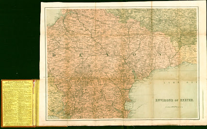
Bartholomew Imperial Map 2a - Exeter
Size: 345 x 450 mm. Scale of Miles (8 = 49 mm).
ENVIRONS OF EXETER (Ee). Imprint: London: W H Smith & Son, 186 Strand (CaOS). Engraver's signature: J Bartholomew, Edinr. (EeOS).
Although titled Exeter it nearly covers nearly the whole of the county: the map covers an area from Dartmoor and Kingswear to Plymouth (ie missing some of the South Hams) and west to Clovelly (missing the western border with Cornwall from Launceston northwards). Railway only to Okehampton then projected. Lines to Moreton Hampstead, Axmouth, Launceston, Exmouth, Kingswear with Brixham, Bideford and Taunton-Barnstaple completed 1873. Most other lines projected as usual. Illustrated.
1. 1874 W H Smith & Son’s Reduced Ordnance Map Of Exeter And Environs
London. W H Smith & Son. (1874). KB.
2. 1874 Railways are consistent with a date earlier than 1878, ie line to Sidmouth (1874).
W H Smith & Son’s Reduced Ordnance Map Of Exeter And Environs
London. W H Smith & Son. (1878). E.
3. 1884 Railways to Holsworthy (1879) and Ashton (1882).
W H Smith & Son’s Reduced Ordnance Map Of Exeter And Environs
London. W H Smith & Son. (1884). FB.
Bartholomew Imperial Map 2b - Plymouth & Dartmoor
Size: 330 x 445 mm. Scale of Miles (8 = 50 mm).
ENVIRONS OF PLYMOUTH AND DARTMOOR (Aa). Imprint: London: W H Smith & Son, 186 Strand (CaOS). Engraver's signature: J Bartholomew, Edinr. (EeOS).
Nearly covers all of south and west Devon: from Cornwall/Devon border at Bude Bay south to Gerrans Bay; River Exe and Exmouth east; to Churchleigh in the noth. Railways to Holsworthy (1879) and Ashton (1882) with line to Kingswear projected. Illustrated.
1. 1884 W H Smith & Son’s Reduced Ordnance Map Of Plymouth And Environs
London. W H Smith & Son. (1884). KB.
Bartholomew Imperial Map 3 - maps published by Houlston & Wright / Houlston & Sons
Bartholomew Imperial Map 4 - maps used by Milligan etc. for guides to Ilfracombe
Bartholomew Imperial Map 5 - hunting maps for Hiorns & Miller
Bartholomew Imperial Map 6 - The Royal Atlas
Bartholomew Imperial Map 7 - Abel Heywood´s guide to Ilfracombe
Bartholomew Imperial Map 8 - Pearson´s Gossipy Guide
In addition Bartholomew produced two further maps of South Devon for W H Smith:
RETURN to List of Bartholomew Maps
NOTES:
[1] Pocklington, G R; The
Story of W H Smith.; London; 1921.
[2] Anthony Taylor; Culm
Valley Album; private printing.


No comments:
Post a Comment