Sunday, 8 October 2023

 TWISS FAMILY

Twiss 3

At some time around 1894 Twiss and Sons were selling three maps which were very similar in scale and coloration to Ordnance Survey sheets available at the time. The maps were possibly completed at the time that folding maps of North Devon were being published by the OS (sheets 276, 277, 278, 292, 293 and 294). These were combined to form one map, revised in 1896-7 and published by the Ordnance Survey (c.f. for other OS tourist maps). This was then reprinted at the Survey Office in 1901 and 1903 etc.

The maps may well have been based on the earlier individual sheets, so publication between 1894 and 1897 is assumed. The three maps were issued together either in a slip case with an added map of Ilfracombe (Twiss 6) or in the current guide book, but in a more expensive edition. Two of the maps are also found in a small card cover together with the plan of Ilfracombe.


Size: 400 x 320 mm. Scale of English Miles (2 = 50 mm).

TWISS & SON'S ENVIRONS OF ILFRACOMBE BARNSTAPLE, &c. IN THE COUNTY OF DEVON (Aa) with scale bar below. No imprints or signature: Copyright (AeOS).

Shows an area from Westward Ho in the south west to Combmartin and just including Upcott (Ee). There is no railway line to Lynton (completed 1898).[1] Map is identical in style to Twiss 4 and 5.

1. 1894 a) Map is found together with Twiss and Sons' Plan of Ilfracombe (see Twiss 6). Two folding maps in burgundy card covers labelled: New Ordnance Survey followed by title below.


Twiss & Sons’ Environs of Ilfracombe and Barnstaple with plan of Ilfracombe ..
Ilfracombe. Twiss & Sons. (1894). KB.

b) The map is one of four in a slipcase. See also Twiss 4, 5 and 6. Map has title etc as above.

New Ordnance Survey. Map 2. Environs of Ilfracombe and Barnstaple
Ilfracombe. Twiss & Sons. (1894). KB.

c) The map is included in the guide book:

Twiss & Sons’ Illustrated Guide to Ilfracombe and North Devon [2] Ilfracombe. Twiss & Sons. (1897).


NOTES:


[1] This map is highly unusual as it provides background information on sites of interest, eg at East Barton – remains of a barton - or at Mattocks Down – site of a battle; this indicates use of OS maps as basis. This would appear to be the first map to label such items of interest since the annotated maps of Bowen.

[2] This edition of the guide book is identical to others listed but was clearly a better edition. This had a green cover (the cheaper edition was light brown or red) and cost Two Shillings Nett (as opposed to One Shilling Nett) and included the three Ordnance Survey maps, Twiss 3, 4 and 5. An L&SWR advert is dated 1897.

TWISS FAMILY 

Twiss 2 

Although Richard Doddridge Blackmore (1825-1900) was born at Longworth in Oxfordshire, he had westcountry connections: he was educated at Blundell's School, Tiverton, (and subsequently Exeter College, Oxford) and his father, John Blackmore, had accepted a curacy in Culmstock in 1826 following the death of his wife and sister-in-law from typhoid fever (and later at Ashford, near Barnstaple in 1835). In addition R D Blackmore’s grandfather was Rector of Combe Martin and Oare. His uncle was Rector of Charles, a little village on the fringe of the Exmoor.

Richard was called to the Bar in 1852 but retired through ill health; after teaching Classics at Twickenham School for a short time; he took up horticulture and market gardening. He wrote a number of novels and works of poetry before he wrote Lorna Doone, which was published modestly in 1869. There were outlaws called Doone on Exmoor and Blackmore had probably heard stories when he was younger. In those days both Exmoor and Dartmoor were remote and inaccessible spots and made excellent hideouts for fugitives on the run.

In 1865, before he began to write Lorna Doone, Blackmore visited Lynmouth and stayed at the Rising Sun Inn as a base for his research. Only since his death has the area around Lank Combe on the west bank of Badgworthy Water been dubbed the Doone Valley. Only 300 of the first 500 copies printed were sold. Nevertheless, Sampson Low Jnr, resolved to risk publishing it and from 1871 the fame of Lorna Doone became established.[1]


Size: 210 x 290 mm. Scale of an inch to a mile.

No title. Scale (but no scale bar) and two imprints: PUBD BY TWISS & SON ILFRACOMBE (Ae) and COPYRIGHT (Ee).

Showing an area from Haddons Mouth, Highveer Point and the Hunters Inn to Oare and Glenthorn, including places mentioned in Lorna Doone such as Doone Valley and Badgworthy Water. Illustrated page 327.

1. 1888      Twiss & Son’s Illustrated Guide to Ilfracombe and North Devon
                   Ilfracombe. Twiss & Son. 1888, (1889). KB; KB.

                    Twiss & Son’s Guide to Lynton and Lynmouth by     William Riddell Esq.[2]
                    Ilfracombe. Twiss & Son. (1889). DevA.


                    Twiss & Son’s Guide to Lynton and Lynmouth by William Riddell Esq.[3] First Edition
                Ilfracombe. Twiss & Son. (1889). KB.


NOTES:

[1] This text is a summary of the interesting article to be found at http://www.lynton-lynmouth-tourism.co.uk/blackmore_and_lorna_doone.htm.


[2] Exeter have dated their copy to 1864: date must be an error. Cover title is Twiss and Son’s Shilling Hand Book to Lynton and Lynmouth and Neighbourhood.


[3] Cover title is Twiss and Son’s Sixpenny Lynton and Lynmouth Guide. Title page has Sketch Maps of the District, but only this map is present.

 TWISS FAMILY 


The Twiss family took over Banfield‘s Library, and hence Stewart and subsequently Milligan’s business in about 1882, although both businesses were operating concurrently in that year.

For a more detailled account of Banfield´s Library up to 1900, see the opening chapter on Centres of Production - Ilfracombe.

The Twiss family issued a range of maps and the following have been identified:

Twiss 1:  Two maps on one sheet titled NORTH DEVON for Twiss & Son’s Illustrated Guide to Ilfracombe and North Devon. See below.

Twiss 2: Sketch map with no title showing Lorna Doone country.

Twiss 3: Ordnance Survey style map Twiss & Son´s Environs of Ilfracombe etc.

Twiss 4: Ordnance Survey style map Twiss & Son´s Environs of Lynton etc. 

Twiss 5: Ordnance Survey style map Twiss & Son´s Environs of Bideford etc. 

Twiss 6: Twiss & Sons´ Plan of ILFRACOMBE

Twiss 7: New map of NORTH DEVON.

 
Twiss 1

Twiss and Son came into possession of the Rev. Tugwell´s popular work on North Devon, The North Devon Handbook, and the extracts and proceeded to reissue them. The first edition of Twiss & Son’s Illustrated Guide to Ilfracombe and North Devon was dated (in the preface) 1888. Later issues are difficult to date: a new issue appeared c.1893 (Twiss and Sons) on the evidence of an advert for the L&SWR dated May of that year. There were new headers and "tail pieces" but minimal text (mainly layout) alterations. A new edition appeared c.1893 with updated text, new illustrations (mainly photographs) and meteorological data from 1891. 

Size: 300 x 375 mm (combined). Scale of English Miles (10 = 50 mm) 
Two maps on one sheet: NORTH DEVON with scale bar (Aa) size: 150 x 375 mm showing an area from Hartland (and Duck Pool) to Bridgewater Bay[1]. ILFRACOMBE. (below) size: 150 x 375 mm  The map shows the coast from The Torrs to Hillsborough Hill and south as far as the railway station. Imprints: Published by Twiss & Sons, The Library, 9 High Str, Ilfracombe. (AeOS) and Bacon's Geographical Establishment, 127 Strand, Lond. (EeOS) (both within frame lines). To the right within the map is a reference to the library: Mrs Twiss & Son's Business Establishments thus II which is clearly marked. The section of the Bacon map shown is from the New Ordnance Atlas (see Bacon 1). 


1. 1888  Twiss & Son’s Illustrated Guide to Ilfracombe and North Devon ..

             Ilfracombe. Twiss & Son. 1888, (1889[2]).  KB, BL[3]; KB.


          Twiss & Sons’ Illustrated Guide to Ilfracombe and North Devon ..
                     Ilfracombe. Twiss & Sons. (1893[4]). KB.


2. 1894 Bacon imprint removed. The map is one of four in a slipcase. See also Twiss 3, 4 and 5.


            New Ordnance Survey. Map 4. Map of Ilfracombe And Railway Map of North Devon and Somerset
              Ilfracombe. Twiss & Sons. (1894).  KB.


3. 1894  Both maps reduced in size: 175 x 255 mm. Title above (CaOS) and blank area (Aa) show where title and scale bar were removed. Reference to Twiss premises in map area removed (but buildings still heavy black as before) and no imprint.


                 The Album of Ilfracombe and North Devon Views
               London. Charles, Reynolds and Co[5]. (1894).  KB.


4. 1894  Plan of Ilfracombe only. Size: 150 x 365 mm. Reference to Twiss premises in map area and imprint are present. New buildings (Wilder Road) and roads including Cambridge Grove, the Victorian Pavilion on the Promenade and the Granville Hotel with two approach roads. 

            The Album of North Devon Views
             Ilfracombe. Twiss & Sons. (1894).  KB.


Examples of "Headers" and "Tail Pieces" used by Twiss


NOTES:

[1] The north coast is taken from part of Sheet 6 of Bacon's Road Map of England in 7 Sheets which was available from c.1887. The same plates were later used for his Waistcoat-Pocket Series. A pre-1900 map of Devon has not been seen but several c.1903 and later.
[2] As 1888 except for two advert pages which have been amended: one text was originally upside-down; another has different prices for tea.
[3] BL 10368.cc.31.
[4] New head and tailpieces and one railway advert is dated.
[5] The booklet has Charles, Reynolds & Co monogram on cover and page of adverts for his products. Address 26 and 27 Milk Street, London. A second copy in author’s collection has monogram as before but an advert for T Harding, Confectioner and Depot for Photographic Views of Ilfracombe and Neighbourhood, 1 & 2 Arcade, Ilfracombe.

 W J TRYTHALL 

W J Trythall‘s directory appeared (at least) twice: in 1875 and in 1877, each time with a new map. Trythall’s address was the Old Town Printing Works, 100 Old Town Street. It remains a mystery why Trythall had to change the earlier map; perhaps he wanted a newer looking map, rather than just updating the map he already had. In any event, he seems to have fallen back on copying a map produced by Brendon some 20 years earlier. This second map is almost an exact copy of Brendon’s which was lithographed by C R Baggs of Plymouth (c.f.). The second directory listed here also had a map advertising Farley’s Hotel (c.f. Anon - Farley).

 Trythall 1


 Size: 240 x 380 mm.  SCALE OF YARDS (1500 = 80 mm). 

The Half-Crown Three Towns Directory Map of Plymouth, Devonport, & Stonehouse (CaOS). No signature or imprint. Shows area from Torpoint to The Laira and has copious adverts on the reverse. 

1. 1875    The Three Towns Directory for Plymouth, Devonport and Stonehouse                          

               Plymouth. W J Trythall. 1875.  DevA.


 Trythall 2


 Size: 240 x 380 mm. SCALE OF YARDS (1500 = 80 mm). 

TRYTHALL`S DIRECTORY MAP OF PLYMOUTH, STONEHOUSE, AND DEVONPORT (Ce). No signature or imprint. Shows area from Devonport Dock to Catdown and has railway incomplete (changes to single line) at Lower Stoke.   

1. 1877  The Three Towns Directory for Plymouth, Devonport and Stonehouse                          

              Plymouth. W J Trythall. 1877. DevA[1].                        


NOTES:

[1] This also contains an advertisement for Farley’s Hotel which includes a sketch map of Plymouth (see Anon - Farley).

 TORQUAY TIMES

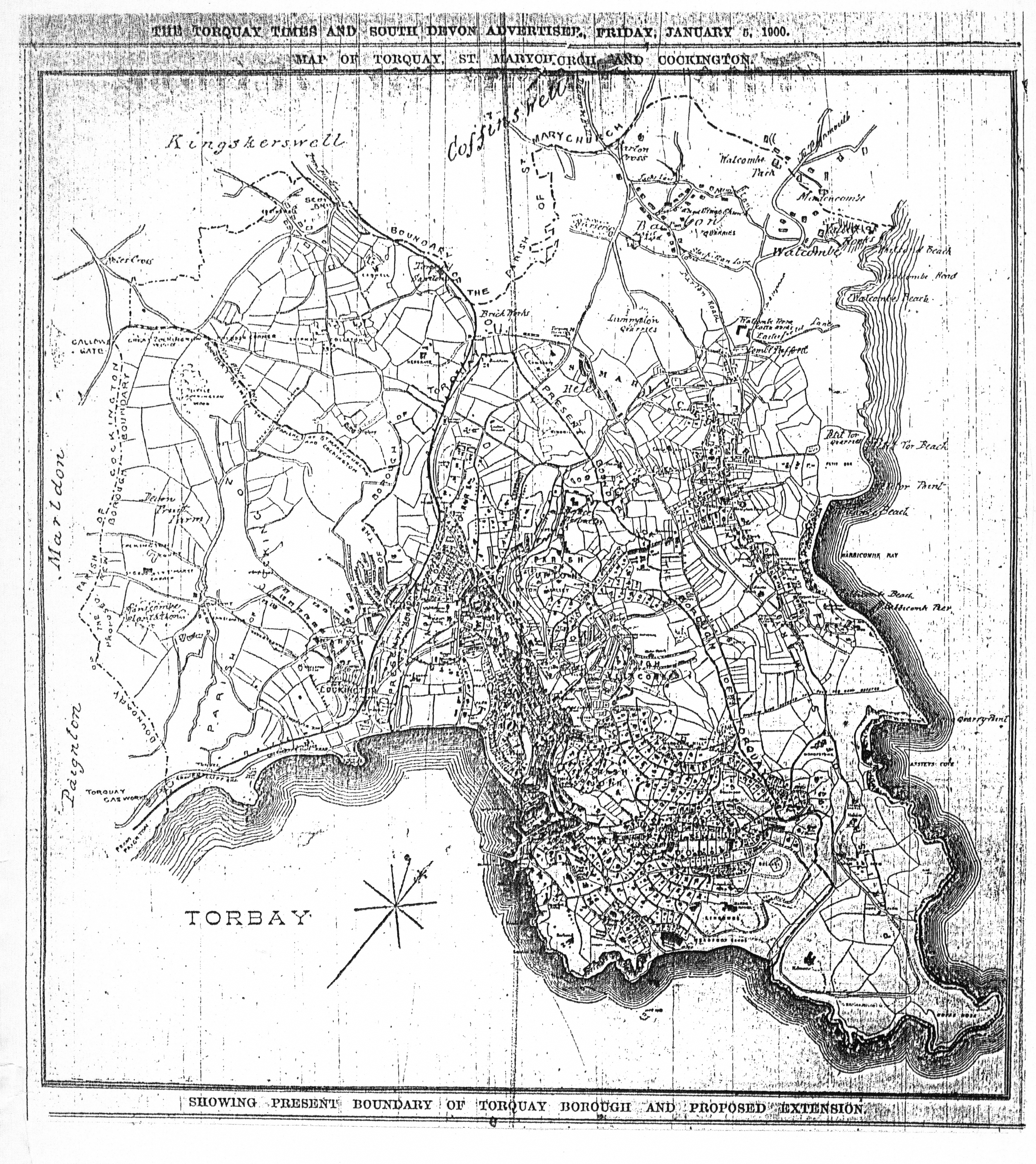
 In 1894 the Torquay Times published a guide to Torquay, Torquay Illustrated. This included a map of the town which had received its Borough Charter in 1892. The fairly detailed map of Torquay is similar in style used by A & C Black (2) but includes Hope’s Nose, which Black would only add to their map six years later. The Torquay Times was being published by the Grogan Brothers at this period.


In January 1900 the Torquay Times and South Devon Advertiser published a new version of this map of Torquay to show the plans concerning the expansion of the young borough. This plan was clearly based on the 1894 map but has been extended to include what was to become the new suburbs of Cockington to the west and St Marychurch to the north. Cockington would be amalgamated in 1900 but St Marychurch was not incorporated into the borough until 1903.


 TORQUAY (Ea). No imprint or signature. No scale but an compass with magnetic north. 

1. 1894   
Torquay Illustrated ... with a map of Torquay and 50 views
Torquay. Torquay Times. (1894). DevA.


2. 1900 No title: a description of the map in one line above and one line below the map and a line above this with the publication details: THE TORQUAY TIMES AND SOUTH DEVON ADVERTISER, FRIDAY, JANUARY 5, 1900. (top) with MAP OF TORQUAY, ST. MARYCHURCH AND COCKINGTON (also top) and SHOWING PRESENT BOUNDARY OF TORQUAY BOROUGH AND PROPOSED EXTENSION. (below). No other imprint or signature. No scale but a compass with magnetic north in bay area (TORBAY). Size: 288  x 265 mm. 

Map of Torquay, St. Marychurch and Cockington
Torquay. Torquay Times and South Devon Advertiser. (1900). TQ[1].


NOTES:

[1] Only seen as a poor photocopy courtesy of Torquay Public Library.

 W ELIOT THOMAS

 Eliot Thomas wrote a short guide to the areas of St Marychurch and Babbacombe toward the end of the nineteenth century. The sketch map of the district covered is very similar to the sketch maps of Torquay and Ilfracombe used by Ward and Lock.

Size: 140 x 207 mm. SCALE (1 = 63 mm) MILE.                                     

ST MARYCHURCH & BABBICOMBE. (Ea). Copyright (Ea). Simple outline map of the area from Union Street (Torquay town centre, Be) north to the coast at Babbacombe but including the eastern peninsula of Hope’s Nose (Ed) and westward to include Watcombe. 


1. 1897            Holiday Guide to St Marychurch & Babbicombe

                        [Torquay. Eliot Thomas]. (1897).   TQ[1], [B], [NLS].


NOTES:

[1] Illustration courtesy of Torquay Reference Library; all rights reserved.

Tuesday, 1 August 2023

 THOMAS TEDRAKE


 Thomas Tedrake of Bideford produced a small pocket guide in 1894. This was printed and published by the Western Express Office. Thomas Tedrake was a printer and publisher with premises at 40 Mill Street. He published both the Western Express (published every Tuesday and Saturday) and the Torrington Chronicle. It would appear that there was no little rivalry between him and Crosbie Coles (c.f.), as two guides to Bideford appeared almost simultaneously.

Tedrake resurrected the Western Express (it was started in the 1860s) and published it together with the Torrington Chronicle from the mid-1880s into the first decade of the twentieth century. About 1908 his wife died and he became ill. Tedrake found buyers who took over the printing of the newspapers and were to pay for the business in instalments. The payments ceased and Tedrake was forced to take repossession only to find ther business was virtually bankrupt. He endeavoured to find a new buyer and thought he was successful only to discover that the prospective purcaser’s wife objected. A protracted court case ensued to recover the promised deposit but Tedrake lost and the papers ceased circulation about 1919.


Size: 85 x 115 mm. ENGLISH MILES (10 = 13 mm).

No title. Simple outline map of the area around Bideford. No signature or imprint. The area covered is from Bude (Ae) east to Down St Mary (Ee) and The Foreland and inland to include Down St Mary and Exmoor Forest.

1. 1894 Tedrake's Guide to Bideford and North Devon Illustrated
            Bideford. Western Express Office. 1894. DevA, KB.


  WILLIAM STEWART

For Stewart´s map 1 executed by Charles King click here.

For Stewart´s map 2 executed by Halfyard see below.


Stewart 2 (Halfyard)

William Stewart had had a map produced, originally lithographed by Charles King of Exeter, for his own reprints of The North Devon Handbook (see Banfield and especially Stewart 1) which appeared in a number of guides between 1872 and 1878. However, shortly before, or immediately after, his business was taken over by Milligan a new plate was engraved. This second map was lithographed by the company of F J Halfyard, of Exeter. Copies of the Fourth Edition of the North Devon Handbook (under Stewart’s imprint) have been seen with either the earlier or the later map. Either Stewart needed new map sheets but did not possess the original plates (or they had become damaged or worn); or Milligan acquired ready-printed copies of the North Devon Handbook which lacked the map and had to have a new map printed before selling the surplus Stewart stock he had.

The new map (by Halfyard) is difficult to differentiate from the first map by King without a direct comparison: however, Halfyard does not name The Tors (on the Ifracombe map); nor does he note the Walk from the Valley of the Rocks (on the Lynton-Lynmouth plan). In the plan of Lynton there appears to be a chain of hills in the lower right corner: in King’s map the hills blend together and are difficult to count; in Halfyard’s map there are 16 definite mounds (although they look more like tussocks!).

Milligan took over the Library at Ilfracombe from W Stewart 1878-79 and immediately began selling the same stock of guide books as his predecessor. This takeover must have occurred shortly after Stewart had printed off a stock of the fourth edition of his Handbook. Milligan & Co.s` Arrival List, Gazette & Advertiser appeared from July 1879 to September 1882 and this may well be roughly the period he ran the Library.

A second map which appeared in guides first printed and published by Milligan was a transfer taken from Bartholomew’s Imperial Map plates. This is a map of North Devon covering a slightly smaller area than that published by W H Smith in the 1880s and 1890s (see B&B 150 states 2, 6 and 10; see Bartholomew for Milligan).

Size: 305 x 385 mm (total). SCALE OF MILES (10 = 75 mm).

Three maps on one sheet: COAST OF NORTH DEVON (scale as above). There are town maps of ILFRACOMBE (155 x 260 mm; SCALE OF CHAINS 5+10 = 37 mm) and LYNTON AND LYNMOUTH (155 x 125 mm; SCALE OF CHAINS 5+20 = 50 mm) below. Imprint: PUBLISHED BY W STEWART, BOOKSELLER, STATIONER & ARRIVAL LIST OFFICE, HIGH STREET, ILFRACOMBE, JUNE 1878. (CeOS). Signature: F J HALFYARD, LITHO, EXETER. (AeOS).

1. 1878 
The map shows the coast from Harland to Minehead. The railway is shown to Ilfracombe.

Stewart's Shilling Guide Book to North Devon: New Edition
Ilfracombe. W Stewart. (1878). BL[1], [P].

2. 1878 Imprint: PUBLISHED BY MILLIGAN & CO. BOOKSELLERS & ARRIVAL LIST OFFICE, HIGH STREET, ILFRACOMBE, 1878. (CeOS).

The North Devon Handbook: Fourth Edition
London: Simpkin, Marshall, And Co. Ilfracombe: W Stewart. (1877)[2]. DevA.

3. 1879 Date in imprint changed to 1879. Illustrated.

Milligan & Co.'s (Late Stewart's) Shilling Guide Book to North Devon. New Edition
Ilfracombe. Milligan & Co. (1879). KB, [Bid].


NOTES:

[1] BL copy is RB.23.a.26316 and a further copy sold by Roger Collicott: Catalogue 60:220.

[2] BL and author have copies with Stewart 1.

 WILLIAM STEWART

William Stewart took over John Banfield‘s business (c.f.) and library circa 1872 and began to issue the same guide books as Banfield based on the work of Tugwell. Although Banfield had already used a map of the North Coast of Devon, Stewart had a new map made including plans of both Ilfracombe and of Lynton with Lynmouth. This was lithographed by Charles King of Exeter. Stewart’s map may well have been based on the similar map by Besley which was first published at about the same time as King also lithographed Besley's map (see Besley 7). This map was replaced by an identical map c. 1878 (see next entry).

For Stewart´s map 1 executed by Charles King see below.
For Stewart´s map 2 executed by Halfyard click here.


Stewart 1

Size: 305 x 385 mm (total). SCALE OF MILES (10 = 75 mm).

Three maps on one sheet: COAST OF NORTH DEVON (scale as above). There are town maps of ILFRACOMBE (155 x 260 mm; SCALE OF CHAINS 5 + 10 = 37 mm) and LYNTON AND LYNMOUTH (155 x 125 mm; SCALE OF CHAINS 5 + 20 = 50 mm) below. Imprint: Published By W Stewart, Bookseller, Stationer &c. Arrival List Office, High Street Ilfracombe, 7 June 1872. (CeOS). Printer's signature: Chas King, Lith, 8 Alma Terrace, St Sidwells, Exeter. (EeOS). Illustrated.

The map shows the coast from Hartland to Minehead. Railways to Ilfracombe, and Barnstaple to Taunton.

1. 1872 Stewart's (late Banfield's) Shilling Guide Book to North Devon: Eighth Edition
Ilfracombe. W Stewart. 1872. TQ, BL[1] .

The North Devon Handbook: Second Edition [2]
Ilfracombe. John Banfield (William Stewart ). (1876). KB.

2. 1872 Printer's signature deleted.

Stewart's Guide to the North of Devon ...The North Devon Guide ... Ninth Edition
Ilfracombe. W Stewart. (1872). KB.

Stewart's Shilling Guide Book to North Devon... Ninth Edition
Ilfracombe. W Stewart. (1876)[3]. KB.

Stewart's Shilling Guide Book to North Devon... New Edition
Ilfracombe. W Stewart. (1876)[4], (1880). KB; DevA.

The North Devon Handbook: Fourth Edition
London: Simpkin, Marshall, And Co. Ilfracombe: W Stewart. (1877)[5]. KB, BL.


NOTES:

[1] BL catalogue has two titles; Banfield's shilling guide-book to North Devon ... Third edition and Stewart's (late Banfield's) six-penny guide-book to North Devon Eighth edition. BL YA.2000.a.14944.

[2]  Edition is same as Banfields’s Second Edition with substitution of Stewart for Banfield on cover title only. Also contains a second map of North Coast, see Banfield 5.

[3] Identical to the New Edition below, probably earlier and title page amended to sound more up to date.

[4] Although the map is dated 1872, the copy known (KB) has a text with latest date of 1876. The text is that of the earlier editions with a number of additions. The Eighth Edition has list of charges dated 2nd August 1867 on pages 35-36. The Ninth Edition and the New Edition have information on a new aisle of 1876 on page 38.

[5] Exeter has a copy with Stewart 2, a close copy of this map.


 E SMITH


The Picnic guide to Ilfracombe and neighbourhood was published in the late 1880s by E Smith & Co. of Bristol with a text attributed to W H Turner of Bristol. A second edition, Picnic: an illustrated guide to Ilfracombe and North Devon, (dated 1890) has been seen with no maps, but the third edition has a total of three maps. In addition to the two maps described below, a further map – Map of the Bristol Channel - was included[1].


Smith, E 1a
Size: 380 x 500 mm. No scale.

MAP OF Ilfracombe SHOWING ROADS, STREETS, TERRACES, CHURCHES, HOTELS, VILLAS ETC. (De in rectangle). Imprint: [PUBLISHED WITH “PICNIC GUIDE” BY E SMITH & Co, BRISTOL] (EeOS) and REGISTERED (AeOS).

Description: Stretches from Holy Trinity Church (Ae) to the Promenade Pier (Ea). Water areas coloured light green as is title panel.


Smith, E 1b
Size: 175 x 475 mm. Scale of (5 = 47 mm) miles.

Map of the COAST OF NORTH DEVON. (Ae). No imprint or signature.

Description: Stretches from Hartland Quay (Ad) to Porlock (Eb). Although key is for roads, only coach roads are shown. Steamer destinations are also illustrated. Water area coloured light green.

Both maps found in:

1. 1891 Picnic: an illustrated guide to Ilfracombe and North Devon, with notes on Lynmouth, Clovelly, Lundy and adjacent regions, including a description of the journey by steamer from Bristol to Ilfracombe / by W.H.Turner.. - Third Edition Bristol. E Smith. 1891. BL, DevA.


NOTES:

[1] This map is 103 x 195 mm has no scale and has an imprint: Published by E Smith, Stone Bridge. It also shows southern Wales with Swansea, Cardiff and Newport. All illustrations courtesy of Devon Archives and Heritage Centre.

 Edward Croydon 4 Shortly after the arrival of the South Devon Railway into Teignmouth, Edwad Croydon published a detailled plan of the town...